Leixão earthcache
 COASTAL EROSION
The sea with its churning currents and pounding waves is, not surprisingly, a very powerful erosional agent.
The physical pressure of walls of water thumping against exposed rock compresses the air in pores and cracks in the rock, forcing it to expand explosively as soon as the pressure is released. This pressure is on average nearly 2500 pounds per square foot (10 tons per square meter) but during a storm it can be five times as great. Soft cliffs can be worn back at a rate of one yard or meter per year by this hydraulic action.
 Boulders and pebbles picked up from the sea bed are hurled at cliff faces, smashing off more fragments. This process is known as corrasion. The boulders and pebbles themselves are smashed and ground down in the process known as attrition.
There is also a chemical reaction between the salts in the seawater and the minerals of some rocks, and a biological reaction involving grazing seasnails and certain kinds of rock-dissolving bacteria. All these effects combine to erode the sea cliffs.
The crumbling headlands
The erosional effects tend to be concentrated on headlands. Waves attack along a front, defined by the direction of the wind and the shape of the sea bed. As waves approach a headland, they slow down as they meet the shallow water near the headland itself, but continue at the same speed at
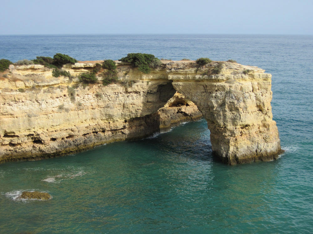
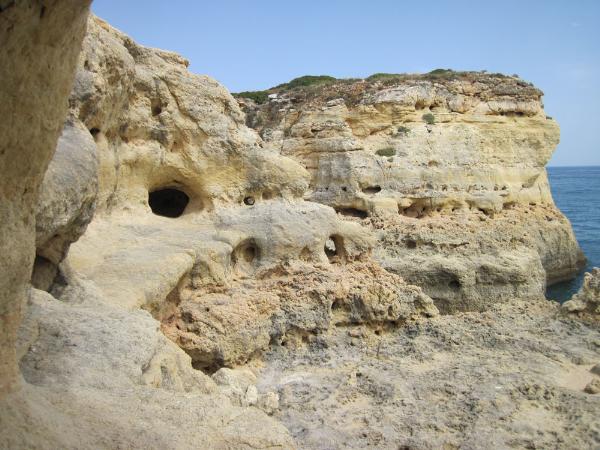
each side. As a result the wave front curves around and attacks both flanks of the headland. Cracks are widened into sea caves, and these are themselves widened by the explosive effect of the hydraulic pressure on the trapped air. Occasionally a hole is blown through the roof, and the incoming wave has a piston effect, blasting air and spray out as a blowhole. Caves on opposite sides of a headland can meet each other, producing a tunnel or a natural arch. Eventually, as the arch is worn away, the lintel falls, leaving the offshore part of the headland isolated. The result is a sea stack, which is itself eventually demolished. Coastlines are continually eroded back by such repeated demolition of headlands.
Wave erosion is confined to the areas that waves can reach. When a sloping coastline is attacked, the waves erode the few yards or meters close to sea level. As the coast is worn back, this cuts a notch which can be quite an even and graceful curve in homogeneous rock. The resulting overhang eventually collapses into the sea. The debris is soon cleared away by current and wave action and the undercutting continues. Erosion takes place by the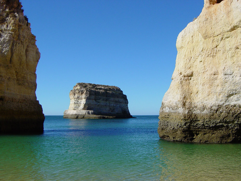 retreat of the cliff so formed. The shape of the cliff is determined largely by its geology. Soft material such as sand or clay forms a sloping crumbling cliff, while something with a relatively even composition and texture forms a fairly smooth vertical surface. Strongly bedded or deeply jointed rocks erode irregularly, erosion being swiftest along the planes of weakness.
Coastal patterns
On a wider scale, the regional geology determines the nature of the coastline. Strata that run parallel to the sea produce a so-called Pacific type coastline with inlets that cut through the ridges and spread out in broad inlets along the softer rock - as in San Francisco Bay - and elongated islands and reefs parallel to the coast. On the other hand, strata that runs straight out to sea produce a deeply indented coastline, with the hard rocks forming long headlands and the soft eroding to long bays. Southwestern Ireland is a magnificent example, and the result is called an Atlantic type coastline. The constant opening up of fresh cliff faces along an area of coastal erosion makes such places ideal prospecting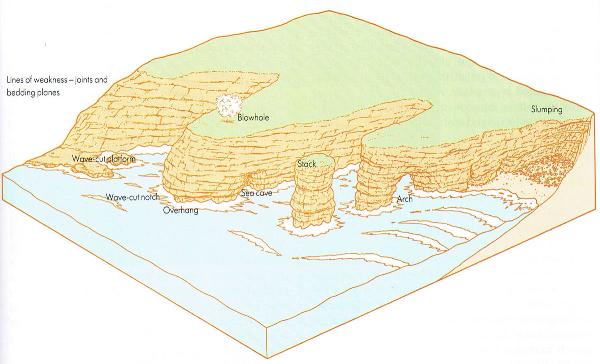 sites.
In a cliff eroded by the sea, the softer beds will erode first, leaving the harder beds jutting out top. When a sea cave forms, the waves tunneling into it will build up a tremendous air pressure, forcing the rocks apart. Any crack forced through to the outside will produce a blast of air and water every time a wave crashes into the cave below. This produces a blowhole left. Headlands are eroded from both sides. The caves and blowholes eroded along the softer rocks and weaker zones may meet in the middle of the headland and form a tunnel or a natural arch. Eventually the roof of the arch will fall, leaving the seaward portion standing as a seastack (Leixão).
(The Practical Geologist)
The Cache:
This is a "5" terrain cache. It is located in "Leixão da Gaivota" about 200 meters from the beach. In order to achieve your goal, please make sure that all this items are satisfied:
-
Never go alone.
-
To go there you have to be a good swimmer and feel at ease in the water.
-
Wait at least two and a half hours after eating any meal.
-
Take proper shoes to walk in rocks.
-
The sea must be very calm, without waves. The climb to the rock is very difficult.
-
Be very careful with inflatable boats. They can blast if they touch the rock.
You make this cache at your own risk. Follow all the items. Don't transform this pleasant activity in a tragedy!
The easy way to do this cache, is going on your one boat, or rent one in the beach.
To claim the cache, you have to:
-
From the PZ facing South, you can see a bed, forming a second floor were you can find the traditional cache "Leixão da Gaivota". What is the thickness of that bed?
-
What is the dip of the bedding plane?
-
There are several bird species that use this rock for nidification. Please tell me the name of three of those species.
-
Optional: take a picture of you with MrGPS, where we can also see the beach.
Mail me the answers, and after permission, make your log.
A Cache:
Esta cache tem nível "5" de terreno. A sua localização é no "Leixão da Gaivota", a aproximadamente 200 metros da praia. A cache não deve ser feita sem observar as seguintes condições:
-
Nunca ir sozinho.
-
Todos devem saber nadar e sentirem-se completamente à vontade dentro de água.
-
O mar deve estar muito calmo, sem ondas. A subida para a rocha é muito difícil.
-
Levar calçado apropriado para andar em cima de rochas.
-
Não devem entrar na água sem completar pelo menos duas horas após qualquer refeição.
-
Muito cuidado com os insufláveis, uma vez que em contacto com a rocha podem rebentar.
A cache é feita por sua conta e risco! Se não cumpre as condições supra citadas, não tente fazer esta cache. Não transforme uma diversão em tragédia!
O modo mais fácil para fazer esta cache, é ir de barco ou alugar um na praia.
Para reclamar a cache, deve responder às seguintes questões:
-
No PZ virado para sul, pode observar uma camada, que forma um patamar onde pode encontrar a cache tradicional "Leixão da Gaivota". Qual a espessura desta camada?
-
Qual a inclinação dessa camada?
-
Existem muitas espécies de aves que nidificam nesta rocha. Identifique no minímo três espécies.
-
Opcional: tire uma fotografia sua com o MrGPS, onde seja possível visualizar também a praia.
Envia-me as respostas por mail, e após autorização faça o seu log.