A “waterfall” is defined as an area where
flowing river water drops abruptly and nearly vertically.
Waterfalls represent major interruptions in river flow. Under most
circumstances, rivers tend to smooth out irregularities in their
flow by processes of erosion and deposition. In time, the long
profile of a river (the graph of its gradient) takes the form of a
smooth curve, steepest toward the source, gentlest toward the mouth
– to the ocean. Waterfalls radically interrupt this curve, and
their presence is a measure of the progress of erosion (upstream
erosion). A waterfall may also be termed a falls or sometimes a
cataract, the latter designation being most common when large
volumes of water are involved – like Niagara, Victória, Iaguaçu,
Angel, etc.. Waterfalls of small height and lesser steepness are
called cascades; this term is often applied to a series of small
falls along a river. Still gentler reaches of rivers that
nonetheless exhibit turbulent flow and white water in response to a
local increase in channel gradient are called rapids.
The majority of waterfalls result from layers of
rock composed of different degrees of hardness, or in some cases a
abruptly cross of a geological fault. Hard layers are more
resistant to erosion. Soft layers are quickly removed. This is
visible all around us in the mountains. The type of waterfall,
where there simply happens to be a cliff in the way of a river,
forms a minority of waterfalls. In this case, over time, the river
will cut into the cliff, reducing the gradient of the waterfall,
until eventually, only a rapid will remain.
Along a carbonated platform most of the summits
are made of resistant limestone and/or dolomite. The softer shale
(and other sediments) layers remain protected beneath these
resistant caps. If a river flows over a lip composed of a layer of
resistant material (like limestone), that lays atop a softer layer
of shale, then the water will remove the soft layer beneath the
limestone at a faster rate. This results in the caves found beneath
many waterfalls. With the erosion progression, some times, a
catastrophic collapse occurs, the cave disappears, and the cliff
face moves further up the valley. In many cases, the hard-soft
layer relationship remains, and the falls simply migrates upstream.
This usually creates a canyon in front of the waterfall. As long as
the hardness differential remains, the waterfall will persist.
Streams become wider and shallower just above
waterfalls due to flowing over the rock shelf, and there is usually
a deep pool just below the waterfall because of the kinetic energy
of the water hitting the bottom. Waterfalls normally form in a
rocky area due to erosion.
In conclusion the waterfalls occur at places in
the river where the topography or height changes. Water runs over a
ledge and falls usually vertically to the next level of the river.
The ledges are usually made of a more resistant bedrock layer,
different from the rest of the river's parent material.
Classifying Waterfalls
Waterfalls are grouped into ten broad classes
based on the average volume of water present on the fall using a
logarithmic scale. Class 10 waterfalls include Niagara Falls, Paulo
Afonso Falls and Khone Falls. Classes of other well-known
waterfalls include Victória Falls 9); Rhine Falls and Sutherland
Falls (Class 8); Angel Falls (Class 7); Yosemite Falls, Lower
Yellowstone Falls (Class 6). Angel Falls (indigenous name:
Parakupa-vena or Kerepakupai merú which means the fall from the
highest point, in Pemon language in Spanish - Salto Del Ángel) is
the world's highest waterfall, with a height of 979m and a clear
drop of 807m. It is located in the Parque Nacional Canaima, in the
Gran Sabana region of - Bolivar State, Venezuela.
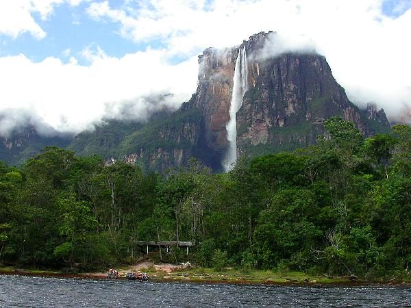
The height of the falls is so great that before
getting anywhere near the ground, the water is atomized by the
strong winds and turned into mist. The mist can be felt a mile
away. The base of the falls feeds into the the Rio Gauya which
flows into the Churun River, a tributary of the Carrao River.
Geological History
In 1841, Charles Lyell, a British scientist and
a father of modern geology came to Niagara Falls. From observations
of the rocks at the Falls and along the Niagara River, Lyell was
able to demonstrate beyond a doubt that the cascading waters had
eroded the gorge from the edge of the escarpment at Queenston -
Lewiston to its present location – upstream erosion. Lyell's
conclusions were supported by an equally distinguished pioneer
American geologist, James Hall. His independent studies for the
State of New York included the first accurate survey of the rim of
the falls to establish a basis for measuring the rate of
recession.
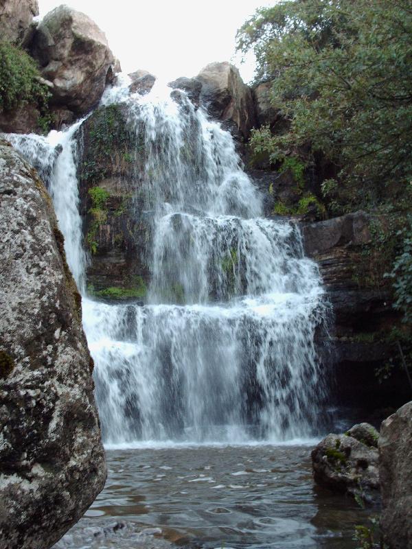
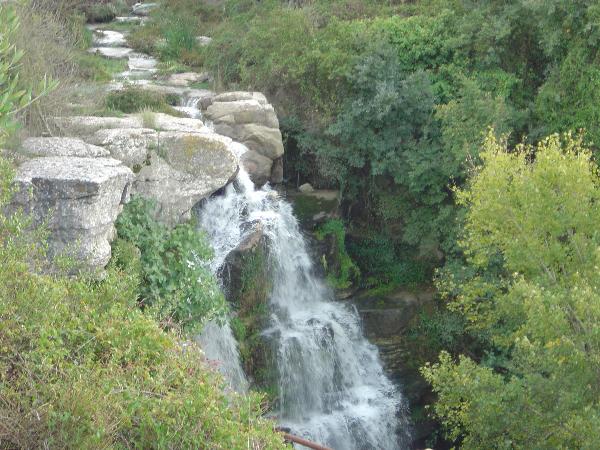
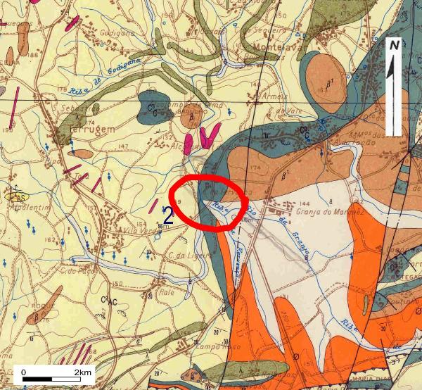
The Fervença water fall corresponds to a
dramatical change of the hardness of the rocks. Not referred in the
geological map, a possible fault could be associated to the
geological limit. The Fervença stream that runs slowly and quietly
along the Granja do Marquês Quaternary sedimentary plain, suddenly
cross a vigorous gorge of cretaceous limestones. The contact
between the cretaceous limestones and also cretaceous soft
mudstones produces a small canyon immediately downstream.
The cache
This cache takes you to the northern Sintra
Platform – the so-called S. João das Lampas Platform, very near the
Granja do Marquês plain. The water fall is located at GZ, but for a
good observation of the geological/geomorfological phenomena you
must stay at N 38º 50’,424 ; W 09º 21’,246. As you could imagine
during Autumn or Winter, with rain, the fall is much more
spectacular…
In order to log your find, your task is answered
the following questions:
1- Measure and/or calculate the dimension of the
waterfall.
2- Tell us the colour of hard limestone on top
of the fall.
3- Finally – not a question! - take a picture of
you and/or your GPS’r with the fall behind.
Answers by the e-mail not in the log.(Using my
profile to send).
The photo should be placed on the log after
confirmation that the answers are correct. Log without photo or log
without authorization will be erased.
Please quote the reference/name of the cache in
your answers.
Em Português - A cache
Esta Earth cache leva-o até à Plataforma a Norte
do Maciço de Sintra a chamada Plataforma de S. João das Lampas, e
muito próximo da superfície da Granja do Marquês. A queda de água
está no ponto 0, mas para uma melhor observação deste fenómeno
geológico/geomorfológico deverá estar posicionado em N 38º 50’,424
; W 09º 21’,246. Como devem imaginar será no Outono e Inverno, com
as chuvas, que esta cascata é mais espectracular…
Para poder fazer o log desta cache, deverá
responder ás seguintes perguntas:
1- Meça e/ou calcule as dimensões da queda de
água.
2- Diga-nos qual a cor dos calcários mais duros
no topo da queda de água.
3- Finalmente – não é uma pergunta! – tire uma
fotografia consigo e/ou com o seu GPS’r com a cascata ao fundo.
As respostas deverão ser enviadas por e-mail e
não colocadas no log.(Usem o nosso perfil para as enviar).
A fotografia deverá ser anexada ao log depois da
confirmação de que as respostas estão correctas. Se fizerem o log
sem a nossa confirmação ou sem a fotografia, este será apagado.
Por favor coloquem no log a referência/nome da
cache nas Vossas respostas.