The Vajont landslide of October 9th, 1963, was one of the severest landslide catastrophes in Europe, when around 260 millions of cubic metres of rock slid into a reservoir, resulting in a flood wave of around 55 million cubic metres shooting into the village of Longarone which was nearly completely destroyed together with some other villages, the death toll being about 2000.
The catastrophe of Vajont was induced by some misjudgements of geological features during the building of a dam barring the small river Vajont - a tributary to the big river Piave - in the province of Friuli-Venezia Giulia in Northern Italy into a reservoir in a high valley east of Longarone. The dam was erected to supply water for the town of Venice during the hot and dry summers in Northern Italy. It was completed in the late 1950s and ranked among the largest dams in the world being 262 metres high, 27 metres thick at the base and 3.4 metres thick at the top.
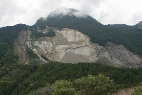
The dam was erected despite several reports of geologists. During the construction of a new street along Monte Toc (1921 m) south of the future reservoir, which is a northern outspur of Col Nudo (2471 m) in the Natural Parc Dolomiti Friulane, several fissures and geological signs of instability of the whole mountain slope were discovered.

Several precursors of the katastrophe during the years 1960-1962 resulting in earthquakes, shakes and landslides alerted the population. In a single day in 1962 the entire side of the mountain Monte Toc moved down by 22 centimetres. Nevertheless building kept in progress.
The Vajont landslide had several causes. The crawling - the movement of the mountain's slope - became apparent in the first place when the dam was finished and the lake was filled. The rising of the water level of the lake destabilized the lower, supporting part of the slope causing an upswelling and weakening of the slope. At the same time, thin layers of swellable clay (Smektit, Montmorillonit and other clay minerals) only a few centimeters thick under the surface were drawing up water, and their stability - i.e. the resistance against shear - was significantly reduced, thus forming a sliding joint. According to other opinions, a sliding joint which remained after a prehistorical landslide was reactivated.
The slope startet to move towards the reservoir in the valley with the rising of the water level.

This crawling movement was not estimated being dramatical since no buildings on the slope were affected. The slope was not steep enough to increase the fear of a sudden movement, since the clay joint still was thought to feature enough friction to decrease the speed of the movement. Estimations were made that the slope would in the worst case slide into the lake quite slowly blocking itself by the masses of rock. The slope’s cross section resembles a chair with a steep backrest of about 40° and approximately horizontal seat. Small slides were calculated for, and sooner or later the “seat” would stop the downsliding “backrest”. Several phases of filling and emptying of the reservoir during the years of 1960 to 1963 were intended to force the slope of Monte Toc to react this way, but the hopes proved to be wrong. With increasing water level in the reservoir the crawling movement accelerated, until on October 9th, 1963, the lake being emptied by this time, the level of the water being several meters lower (Question 1: how many meters lower?) as in the phase of filling before, the former slow crawling movement increased in a few minutes time dramatically from a few centimeters per day until the rock masses finally hit the water level of the reservoir at a speed of about 100km/h.
A report of 1985 states that two main factors could be alone responsible for the landslide (Question 2: which factors?). In vertical fissures in the rock opening up during the movement of the slope water could be trapped. Also the water filling the reservoir might have had not drained quick enough. The hydrostatical pressure of the water builds up an enormous horizontal pressure. Besides, in the sliding joint the friction must have been reduced abruptly, as Leopold Mueller, one of the specialists consulted after the catastrophe, pointed out. According to his statement, the movement of the material reduced the stability of the material (Question 3: What is the scientific terminus for this effect?).
An explanation for the loss of friction might be that the pressure in the microscopic water filled fissures of the clay layers could have increased so much that the pressure might have lifted the whole mass of the slope and carried it down the valley. In this case the slope would have moved without friction into the reservoir.
By the steady crawling of the slope (viscoplastic flow) frictional heat was caused. This state remained stable for years, since the slope was crawling for quite a long time, but the heat was dissipated to the surrounding rock material without causing a significant rise of temperature in the water filled clay. If the water in the pores of the clay warms up, the pressure in the pores rises since the nearly impermeable clay dewaters very slowly, the stability of the layer decreases and the crawling accelerates. The speed of crawling increased during a period of 5 months from under one centimeter per day to more than 10 cm on the day of the final landslide. At first, the estimated temperature in the clay layer relative to the rock material rose only by about 3°C to about 23°C. Approximately 3 weeks prior to the catastrophe a change took place. The increase of temperature concentrated to the thin sliding layer in the middle of the clay layers. The process became increasingly adiabatic with the heat staying in the clay. Before, at least as much heat as was produced was dissipated to the environment, but now the rising temperature weakened the sliding joint and the velocity of crawling grew. This resulted in more frictional heat, which in turn influenced the shear resistance. The system got into a critical state with the temperature rising up to 36°C. At this temperature the clay theoretically wants to dehydrate and release the trapped water. This effect leads to an abrupt, nearly explosive increase of the water pressure in the clay pores (taking place in a few minutes) causing the shear resistance of the slope to break down and the rock masses sliding into the reservoir.
The dam remained nearly untouched by the flood caused by the landslide and stands till today, setting a memorial to the catastrophe.

Near the header coordinates you find a small visitors center, a memorial chapel, parking spaces and guided tours along the crown of the dam with explanations on the geology and the landslide.
To fulfil the logging requirements for the cache, send the answers to the questions above in the text and Question 4: a rough estimation of the height and width of the huge smooth area which was left by the sliding rock mass exposing the sliding joint layer on the slope of Monte Toc via our profile email (do not answer the questions in your log!). Please log right away, you do not need to wait for our permission. We will contact you if the answers are wrong. When logging attach a picture to your log showing you/your team with your GPSr in front of the dam (for single cachers the GPSr in front of the dam will do; not mandatory) .
Note to another point of interest: walking or driving up to the village of Erto on the opposite of Monto Toc and walking the path next to the cemetary to N 46°16.169, 012°19.556 gives a great overview over the former reservoir, the dam, the naked Monte Toc slopes and the rock masses in the reservoir.

Information in Italian language is also given in the two nearby Traditional caches "Vajont" (GC1BN7P) and "Diga del Vajont" (GC15GAQ).
Happy caching!