From the guidelines, as from January 2013: "People do not need to wait for permission to log your EarthCache. Requiring someone to wait is not supported by the EarthCache guidelines. People should send their logging task answers to you, then log your EarthCache. When you review their logging task answers, if there is a problem, you should contact them to resolve it. If there is no problem, then their log simply stands."

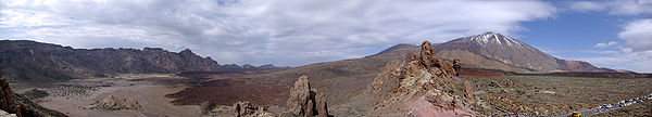
Pico Viejo N28º 14.306 W16º 41.889 - Parque Nacional del Teide, Tenerife
Pico Viejo is a stratavolcano within the Teide National Park situated in Tenerife (Canary Island Archipelago). The National Park’s official name is Parque Nacional del Teide and offers views out of this world.
The Canary islands
The Canary Islands are a Spanish archipelago which, in turn, forms one of the Spanish Autonomous 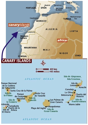 Communities and an Outermost Region of the European Union. The archipelago is located just off the northwest coast of mainland Africa, 100 km west of the disputed border between Morocco and the Western Sahara.
The archipelago is made up of 7 main islands: Tenerife, Gran Canaria, Fuerteventura, La palma, Lanzarote, el Hierro and La Gomera. In addition there are the islands La Graciosa, Alegranza, Montaña Clara, Roque del Este and Roque del Oeste that belong to the Chinijo Archipelago that lies just north of Lanzarote Island.
General geology
The originally volcanic islands –seven major islands, one minor island, and several small islets– were formed by the Canary hotspot. The Canary Islands is the only place in Spain where volcanic eruptions have been recorded during the Modern Era, with some volcanoes still active.
Teide
Mount Teide or, in Spanish, El Teide, is the highest elevation of Spain and the islands of the Atlantic (it is the third largest volcano in the world from its base) is 3.718 meters. Is an active though dormant volcano which last erupted in 1909 from the El Chinyero vent on the Santiago (northwestern) rift and is located on Tenerife, Canary Islands. The volcano and its surroundings comprise the Teide National Park (Parque Nacional del Teide in Spanish). The park has an area of 18900 ha and was named a World Heritage Site by UNESCO on June 29, 2007. It is also from the end of 2007 one of the Twelve Treasures of Spain. Territorially belongs to the municipality of La Orotava.
At 3718 m above sea level, and approximately 7500 m above the floor of the Atlantic Ocean, Teide is the highest mountain in Spain, highest point in the Atlantic Ocean and the 13th highest mountain in the European Union. The island of Tenerife itself is the third largest volcanic ocean island on Earth by volume. Teide is also the third highest volcano on a volcanic ocean island. It is also unstable and possibly in a more advanced stage of deformation and failure than the much publicised Cumbre Vieja. The United Nations Committee for Disaster Mitigation designated Teide as a Decade Volcano, because of its history of destructive eruptions and its proximity to several large towns, of which the closest are Garachico, Icod de los Vinos and Puerto de la Cruz.
Teide together with its neighbour Pico Viejo and Montaña Blanca form the Central Volcanic Complex.
The stratovolcanoes Teide and Pico Viejo are the most recent centres of activity on the volcanic island of Tenerife. Tenerife has a complex volcanic history. The formation of the island and development of the current Teide volcano can be summarised into five stages, as shown in the diagram to the right.
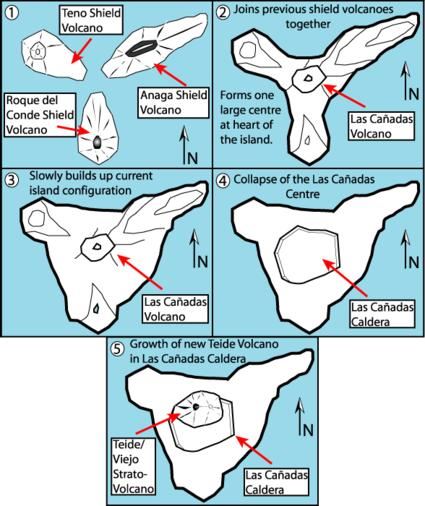 Stage One
Similar to the other Canary Islands, and Volcanic Ocean Islands in general, the island of Tenerife was built by accretion of three large shield volcanoes, which developed in a relatively short period of time. This early shield stage volcanism formed the bulk of the emerged part of Tenerife. The shield volcanoes date back to the Miocene and early Pliocene and are preserved in three isolated and deeply eroded massifs: Anaga (to the NE), Teno (to the NW) and Roque del Conde (to the south).. Each individual shield was apparently constructed in less than three million years and the entire island in about eight million years.
Stages Two and Three
The initial juvenile stage was followed by a period of 2-3 million years of eruptive quiescence and erosion. This cessation of activity is typical of the Canaries, for example La Gomera is currently in this erosional stage. After this period of quiescence the volcanic activity became concentrated within two large edifices; the central volcano of Las Cañadas and the Anaga massif. The Las Cañadas volcano developed over the Miocene shield volcanoes and may have reached 40 km in diameter and a height of 4500 m.
Stage Four
Around 160-220 thousand years ago the summit of the Las Cañadas I volcano collapsed creating the Las Cañadas (Ucanca) caldera. Later a fresh stratovolcano - Las Cañadas II volcano reformed and underwent catastrophic collapse. Detailed mapping indicates that the site of this volcano was in the vicinity of Guajara. The Las Cañadas III volcano formed in the Diego Hernandez sector of the caldera. Detailed mapping indicates that all the Las Cañadas volcanoes attained a maximum altitude similar to that of Teide - which is also referred to as the Las Cañadas IV volcano.
Two theories on the formation of the 16 x 9 km caldera exist.
1- The first is that the depression is the result of a vertical collapse of the volcano. The collapse being triggered by the emptying of shallow (at or about sea level) magma chambers under the Las Cañadas volcano after large-volume explosive eruptions.
2- The second theory is that the caldera was formed by a series of lateral gravitational collapses, similar to those described in Hawaii. Evidence for the later theory has been found in both onshore observations and marine geology studies.
Stage Five
The most recent activity on the island is the NW and NE rifts and the Pico Teide/Viejo stratovolcanoes, erupted material from which partially fill the Las Cañadas caldera. The rifts can be seen as prominent ridges running NE and NW through the island from the Las Cañadas caldera. The rifts are also believed to have built the previous Las Cañadas volcano, and had a part in its collapse. Since the collapse, eruptives from the rifts have filled the resulting embayment with increasingly differentiated lavas and finally developed the Teide and Pico Viejo stratovolcanoes, nested in the embayment itself.
 The EarthCache
You have plenty of opportunity to view Teide from many angles along your travels through the Cañadas. However, this spot shows your in vivid colour the devastation from volcanic eruptions, in particular from the Pico Viejo.
In order to qualify for a found of this EarthCache I ask you to reply to the following questions and e-mail the answers to me via my GC- Profile:
-
What two colours do you see around the crater in Pico Viejo?
-
When did the last eruption take place here?
-
What is the first name of the eyewitness that recalls the days events?
-
It is said that the eruption started with a large fissure. How long was this fissure?
-
What, from the information board in front of you, is said to be at point D?
Note: Platinum EarthCache level "ribbon" courtesy of Play mobil.
References:
http://en.wikipedia.org/wiki/Teide
Teide National Park. Ediciones A.M.

 The most exciting way to learn about the Earth and its processes is to get into the outdoors and experience it first-hand. Visiting an Earthcache is a great outdoor activity the whole family can enjoy. An Earthcache is a special place that people can visit to learn about a unique geoscience feature or aspect of our Earth. Earthcaches include a set of educational notes and the details about where to find the location (latitude and longitude). Visitors to Earthcaches can see how our planet has been shaped by geological processes, how we manage the resources and how scientists gather evidence to learn about the Earth. To find out more click HERE.