Da leider die vorherige Plattform mit Foto-Koordinaten und Infotafeln dem aktiven Abbau zum Opfer gefallen ist, bekommt ihr hier die Übergangsfragen, bis zur Fertigstellung der neuen Plattform (geplant war 2013/2014 bis heute in 2025 hat sich leider noch nichts getan diesbezüglich und fast alle Infotafeln sind mittlerweile auch vom Parkplatz verschwunden):
Fotopunkt (und Parken in der Nähe):
N50 24.077 E007 19.214
Zum Loggen des Earthcaches bitte folgende 3 Voraussetzungen erfüllen:
1) Foto an den genannten Koordinaten von euch oder eurem GPS und in beiden Fällen mit einem Zettel und Angabe eures Nicknamens und dem Datum, wann ihr hier wart - diese Art der Logbedingung ist seit der Guidelineänderung vom 10.06.2019 wieder erlaubt:
2) Bitte die Antworten zu den Übergangsfragen an mich senden, Loggen könnt ihr direkt, ich melde mich, wenn etwas nicht stimmt oder fehlt:
a) wie alt ist der Eppelsberg laut Infotafel ca?
b) Wieviele hoch ist die Wand laut Infotafel?
c) Welche Zahl ist dem Eppelsberg auf der Tafel mit der Karte Rund um Maria Laach zugewiesen?
3) wie vorher ein Modell des Schlackenkegels anfertigen und ein Bild davon mit hochladen
Danke für den Besuch, die weiteren Infos erhaltet ihr hier im "alten" Listing:
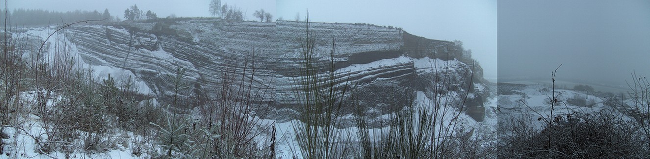
Foto und Antworten auf die Fragen bei: N50 24.197 E007 19.125
Parken bei: N50 24.058 E007 19.216
Schlackenkegel:
Zu Beginn der vulkanischen Tätigkeit bildet sich ein Einbruchskrater, um den sich ein Ringwall aufbaut. In der Hauptausbruchsphase wächst der eigentliche Schlackenkegel, der sich in die Einheiten Krater und Schlackenwall gliedern lässt. In den Bereich des Kraters ragt der Schlot, durch den das glutflüssige Magma aufgestiegen ist. Der Schlackenwall baut mit seinem Innen- und Außenwall den Vulkankegel auf, der von Deckschichten überlagert wird.
Im Eppelsberg entstanden die Schichten durch zwei verschiedene Transportarten von vulkanischem und nicht vulkanischem Material. Es überwiegen Fallablagerungen, die entstehen, wenn das aus dem Schlot geschleuderte Material in der Eruptionssäule in die Atmosphäre aufsteigt und durch vorherrschende Winde in einer Eruptionswolke verdriftet wird. Die Partikel regnen dann in Abhängigkeit von ihrem Gewicht früher oder später als sogenanntes Fallout aus der Eruptionswolke aus. Die Fallablagerungen zeichnen sich, wie auch im Steinbruch des Eppelsbergs, durch eine gleichbleibende Schmächtigkeit aus, die mit zunehmender Entfernung vom Ausbruchszentrum abnimmt.
Steigt eine Eruptionssäule nicht hoch auf, sondern breitet sich vom Ausbruchszentrum am Boden als materialbeladene Wolke aus, bilden sich Bodenwolkenablagerungen. Entfernen sich materialarme Druckwellen bzw. Hochgeschindigkeits-Wolken (surges) vom Krater, entstehen sogenannte Surge-Ablagerungen. Einen Hinweis auf diese Transportart liefern die wechselnden Mächtigkeiten der Schichten sowie das Ausdünnen der Schichten an Hindernissen und die Einregelung von nichtvulkanischem Gestein in Ausbreitungsrichtung der Bodenwolken.
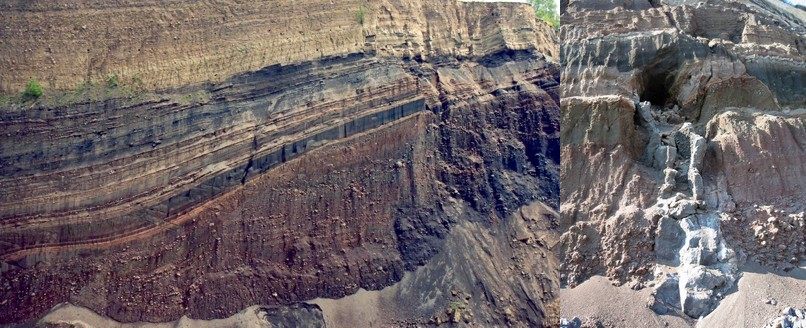
Während des Eppelsberg-Vulkanausbruches wurde ein glutflüssiger Lavafetzen während des Fluges rundlich geformt und erstarrte zu einer vulkanischen Bombe. Diese etwa 3 Tonnen schwere Bombe schlug in etwa 200 Meter Entfernung zum Ausbruchszentrum in den Schlackenwall ein. Der dahinterliegende ca. 7 Tonnen schwere Block entstammt dem Kraterbereich des Eppelsberg-Vulkanes. Er setzt sich aus miteinander verschweißten Lavafetzen zusammen, die während der magmatischen Ausbruchsphase auf den Kraterrand geschleudert wurden. Von dort rollte der riesige Block auf dem übersteilten Innenwall des Schlackenkegels zurück in den Kraterbereich. Bombe und Block wurden im Zuge des Abbaus im Steinbruch freigelegt und zur Ansicht an einen anderen Ort transportiert (in der Nähe einer der Schautafeln am Parkplatz).
Der Eppelsberg Schlackenkegel ist ca 200.000 Jahre alt

Um diesen Earthcache zu loggen ist folgendes zu tun:
Vor dem Loggen bitte vor Ort die Antworten auf folgende Fragen suchen und per Mail an mich:
1) Wieviele Schautafeln befinden sich an den Koordinaten?
2) Wer nistet in den Hohlräumen des Eppelsberg-Vulkans (3 Namen)?
3) Wie heissen die verschiedenfarbigen Lagen in der oberen Abbauwand?
4) Wie viele Lagen hat das Lapilliband?
5) Wie hoch ist der Schlackenkegel des Vulkans laut einer der Infotafeln (die Höhe der Abbauwand gegenüber ist nicht gemeint, diese betrüge 60 Meter)?
Nach Logfreigabe bitte ein Foto von euch oder eurem GPS an den genannten Koordinaten und eine Zeichnung oder ein Modell des Schlackenkegels hochladen.
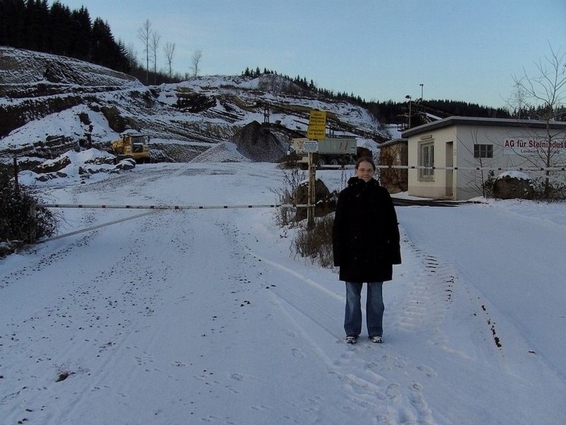
Beispielfoto:

English:
Sadly the old plattform is gone and most of the infos at the parking lot, too - till the new plattform is ready, please use the following Informations to log the Cache:
Picture-Koordinates (and parking nearby):
N50 24.077 E007 19.214
1) Take a Picture at the Coordinates with you or your GPS with a sign showing you nickname and the date you have been here - according to the guideline change from 06/10/2019 it is once again allowed to ask for this picture as a proof:
2) Send the answeres of the following questions to me, you can log directly, i´ll write you an info, if there is something wrong or missing:
a) How old is the Eppelsberg approximately? (look at the infoboards)
b) How high is the wall, given by the infoboard?
c) Which number has the eppelsberg on the map that shows the area around maria laach?
3) Create a drawing or model of the cinder cone and upload a picture of it
Thanks for your visit, all other informations can be read at the "old" listing:
Earthcache Cinder Cone Eppelsberg
Picture and answeres to the questions at: N50 24.197 E007 19.125
Parking at: N50 24.058 E007 19.216
Cinder Cone:
At the beginning of the volcanic activity a break-down crater forms, around this a ring embankment develops itself. In the main outbreak phase grows the actual cinder cone, which can be arranged into the units craters and cinder embankment. Into the range of the crater the chimney rises up, by which the glow-liquid magma ascended. The cinder embankment develops the volcanic cone, which is overlaid by surface layers with its interior and external embankment.
In the Eppelsberg the layers developed from two different modes of conveyance of volcanic and nonvolcanic material. Drop deposits outweigh, which are developed if the material in the eruption column, hurled from the chimney, ascends into the atmosphere and is drifted by predominating hoist in an eruption cloud. The particles stop raining then as a function of their weight sooner or later as so-called fall out from the eruption cloud. The drop deposits are characterised, like also in the quarry of the Eppelsbergs, by a continuous slimness, which decreases with increasing distance from the outbreak center.
If an eruption column does not ascend highly, spread cloud material-loaded by the outbreak center at the ground as, form ground cloud deposits separate. If material-poor pressure waves and/or high-speed clouds (surges) of the crater depart, so-called Surge deposits develop. Supply a reference to this mode of conveyance the changing powerfulnesses of the layers as well as thinning the layers out at obstacles and a regulation not-volcanic rock to direction of propagation of the ground clouds.
During the Eppelsberg volcanic eruption a glow-liquid Lavafrazzle was formed during the flight roundish and solidified to a volcanic bomb. This about 3 tons heavy bomb knocked into approximately 200 meters distance to the outbreak center into the cinder embankment. Approx. 7 tons lying behind the heavy block comes of the crater range the Eppelsberg volcano. It consists of welded with one another Lavafrazzle, which were hurled during magma tables the outbreak phase on the edge of crater. From there the enormous block on the over-divided interior embankment of the cinder cone rolled back into the crater range. Bomb and block were opened in the course of the dismantling in the quarry and transported to the opinion to another place (in the proximity of one of the diagrams at the parking lot). The Eppelsberg cinder cone is approx. 200,000 years old
In order to log this Earthcache please fulfill the following exercises:
Before logging please find the answers to the following questions and mail them to me:
1) How many infoboards are located near the coordinates?
2) Who is nesting at the hollows of the Eppelsberg-Vulcano (3 Names)?
3) What is the name of the different-colored layers at the upper miningwall?
4) How many layers has the Lapilliband?
5) How high is the cinder cone of the vulcano according to one of the informationboards (not the highness of the face vis-à-vis - that averages 60 meters)?
After Logpermission please upload a picture of you or your gps at the mentioned coordinates and a drawing or model of the cinder cone.
Sample picture: