Starohory a Prvohory / Proterozoic and Palaeozoic EarthCache
Starohory a Prvohory / Proterozoic and Palaeozoic
-
Difficulty:
-

-
Terrain:
-
Size:  (not chosen)
Please note Use of geocaching.com services is subject to the terms and conditions
in our disclaimer.
HRANICE MEZI
STAROHORAMI A PRVOHORAMI
BOUNDARY BETWEEN PROTEROZOIC AND
PALAEOZOIC ERAS
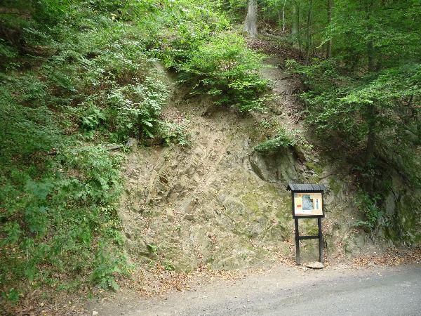

On the uncovered profile you can see the boundary between
two geological eras — Proterozoic and
Palaeozoic.This boundary can be called...................... The
right side of the profile is composed
of ............................... lt arose about 800
millionyears ago from the sedimentation of mud and sand
on the bottom of the sea which once flooded this area.
Mountain making upsurgences within the earth, known as Kadomian
Foldings, swelled
the land and subsided the sea at the end of the Proterozoic era.
Proterozoic sedimentary deposits
were hardened, faulted, and partly transformed through the process
of phyllitization. Due to the
factors of water wind, sun, frost, ect., the upper layers of these
sediments were intensively
destroyed and eroded. On the left side of the profile it is
possible to see ....................................
They developed about 500 million years ago, when the land area
receded and the ocean waters,
later called the Cambrium Sea, returned. The direction and angle of
the Cambrium layers are in
very sharp contrast to the Proterozoic rocks, and therefore show
discordant unconformity. At the
end of the Middle Cambrium age, the sea degressed from this area,
never again to retum.
Several million years later, between Devonian and Carbonian times,
there were groups of
Proterozoic and Paleozoic layers faulted and deformed by land
upswellings known as Hercynian foldings.
And now your task:
To log this Earthcache, take a photo of yourself close to the
information panel and send me
(
email
in
profile) the correct answers
of the following questions:
1. What is the name of this boundary?
2. What is the composition of the left and the right side of the
boundary?
Please do not wait for the approval to log the cache after sending
the answers. Log it directly
and we will contact you if anything is wrong!!!!!!!

Na odkrytem profilu hornin vidite hranici mezi dvema
geologickymi erami starohorami (proterozoikem)
a prvohorami (paleozoikem).Hranice se
nazývá................................Pravou cást profilu
tvorí........................
Vznikly asi pred 800 milionylety usazovanim bahna a pisku na dne
more ktere, zaplavovalo zdejší krajinu.
Horotvorne sily koncem proterozoika (kadomske vrasneni)
vyzdvihly ulozeniny a more ustoupilo.
Proterozoicke ulozeniny (sedimenty) byly deformovany, poruseny
zlomy a slabe pretvoreny (fylitizovany).
Pusobenim povetrnostnich vlivu (voda, slunce, vitr, mraz ap.)
doslo k intenzivnimu zvetravani a odnosu vrchni
casti souvrstvi. V leve casti profilu jsou dobre patrne
vrstvy....................... Byly ulozeny pred 500 miliony
let, kdyz Uzemi opet pokleslo a bylo zaplaveno kambrickym morem.
Smer a sklon kambrickych vrstev
je v ostrem Uhlu k proterozoickym horninam. Koncem stredniho
kambria more ze zdejsiho uzemi
ustoupilo jiz natrvalo. O mnoho milionu let pozdeji na prelomu
devonu a karbonu byl cely vrstevni sled
hornin proterozoika i paleozoika znovu deformovan a porusen
horotvornymi silami variskeho vrasneni.
A nyní ukoly:
Do logu vložte fotografii s vami a info tabuli a odpovezte (email
pres profil) na otazky:
1. Jak se nazývá tato hranice?
2. Co tvori pravou a levou cast profilu?
Na schválení odpovedí necekejte!!!!!
Additional Hints
(No hints available.)