
Geocache of the week november 3, 2021
The icecap covers 81% of Greenland. During the last 2-3 milion years there have been an icecap on Greenland. The ice represents 10% of all freshwater on earth. If the whole icecap melted the seas would rise 6-7 meter all over the world.

Sådan logger du en earthcache:
Send en mail til mig med svarene på de spørgsmål, der stilles FØR du logger cachen.
Du kan logge cachen som fundet umiddelbart efter du har mailet svarene. jeg kontakter dig, hvis svarene er forkerte.
Læs opgaven grundigt, så du er sikker på at du får alle oplysninger med. Dine svar må IKKE fremgå af selve logningen.
How to log an earthcache:
Send an email to me with the answers to the questions from the cache description BEFORE you log the cache as "found it".
You can log the cache as found immediately after you have mailed the answers. I will contact you if the answers are wrong.
Read the questions carefuly in order to get all the information you need. DON'T write the answers together with your log. |
Illulisat Icefjord.
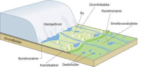
when melting an icecap diferent kinds of earth are made. It can be moraine, glacial and postglacial clay, sand and silt.
During my first visit in Greenland September 09 I stayed in Ilulissat for some days. I went to see the icefjord and I fell in love with the icebergs immediately! The Icefjord was part of Unescos world heritage programme since 2004. No wonder why! It's amazing to see all that ice. The glacier is the most active on the northern part of the world sending out 70 million tons of ice into the ocean every day. The ice is melting. Not because of global warming (probably), but because of natural warm water in the sea. The glacier is one of the only places where the icecap, which covers most of Greenland, reaches the sea. Take a walk out to se this fantastic ice sculptures. Go to the old heliport and follow the blue track. Shortly after the trail start you will reach a little beach at N69°12.102W51° 07.572 There is a warning sign telling of a kind of "geological" danger.
To log this cache send a mail to my profile and tell me:
1) why is it dangerous to enter the beach (read the text on the sign).
2) Explain the mechanism behind the danger.
3:BONUS QUESTION, optional: See if you can find any local people who can tell you some stories about this phenomenon; the dangerous thing mentioned on the sign. You can log the cache as "found it" after sending me an email. You don't have to wait for my accept.
Optional:you Take and upload a picture of yourself in front of that beach.
Please make sure that the text on the sign cannot be seen on the photo
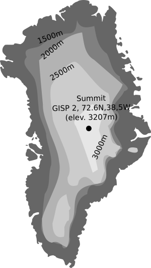 map showing the icecap in Greenland and the heights of the cap.
click here if you want to see an animation glacier "in action".