Doc: Big Basin to Waddell Beach Traditional Geocache
Doc: Big Basin to Waddell Beach
-
Difficulty:
-

-
Terrain:
-

Size:  (small)
Please note Use of geocaching.com services is subject to the terms and conditions
in our disclaimer.
A wonderful open area with great views of the coast! If you haven't taken a break at Mt. McAbee, this is a good place to lunch.
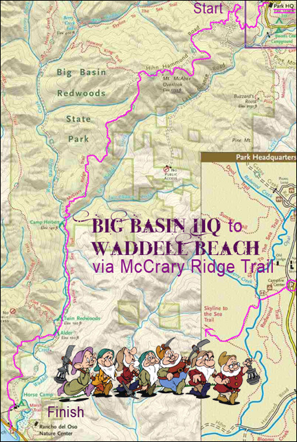
BIG BASIN HQ to WADDELL CREEK BEACH
(via the Howard King/ McCrary Ridge trails)
This route is an alternate to the more traditional ‘Skyline to the Sea’ route. Although there is a vertical component to this path that is not part of the West Waddell Creek route (the climb to Mt McAbee Overlook), this is more than overcompensated by the continual views of the coast and surrounding peaks that will accompany you on your trip.
The McCrary Ridge Trail from Mt McAbee Overlook to West Waddell is well maintained, wide and clear from overhanging underbrush. Waddell Beach is visible from a good portion of this trail. My GPS put the walking part of the trip at a little over 8 1/2 miles. Though this overall hike may be rated as strenuous, as these kinds of hikes go this one is relatively easy.
To do the trip as outlined, you will need to shuttle. We parked one car at the beach and shuttled another to the park headquarters. The quickest way to the HQ from the beach is (S)Hwy 1/ (L)Bonny Doone/ (L)Pine Flat Rd/ (L)Empire Grade/ (R)Jamison Creek Rd/ (L)236 to park HQ. Allow about 45 - 55 minutes for the driving part of the shuttle.
Fun fact: In the original story, the dwarfs were not named. Disney named them when they animated the story!
Cache is cammo'd baby soda bottle.

Additional Hints
(Decrypt)
Ebpxf, fznyy ohfu.