Jump to english version

Inhalt Deutsch:
Der Todtnauer Wasserfall ist mit 97 Metern der höchste Naturwasserfall Deutschlands. Zwischen Todtnauberg und Aftersteg stürzt das Wasser des Stübenbachs über mehrere Kaskaden in die Tiefe. Zu jeder Jahreszeit ist der Besuch ein Erlebnis. Während im Sommer durch das am Felsen aufgewirbelte Wasser für eine angenehme frische und feuchte Luft für Abkühlung sorgt, bilden sich im Winter oft bizarre Eisformationen.
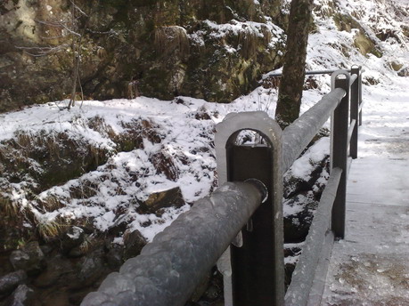
Bizarre Eisformationen am Brückengeländer
Der vollständig naturbelassene Wasserfall steht seit 1987 unter Denkmalschutz und gehört zu den besonderen Naturdenkmälern in Deutschland. Zu erreichen ist der Wasserfall von Todtnauberg, von Aftersteg mit Parkplatz und Kiosk oder von Todtnau im oberen Wiesental. Ein romantischer Weg mit Brücken und Stiegen führt entlang der Fälle.

Der Hauptwasserfall

Entstehung des Wasserfalls:
Entstanden ist der Todtnauer Wasserfall durch die letzte große Eiszeit, durch die Erosionskraft des Eises an einer geologischen Verwerfung (Bruchstelle). Hier floss vor gut 11.000 Jahren das Eis aus dem Todtnauberger Hochtal in den Hauptgletscher des Wiesentals. Mit einer Mächtigkeit von bis zu 500 m schnitt dieser das Wiesental deutlich tiefer ein, als der Stübenbach-Gletscher des Todtnauberger Tal. Dadurch entstand dieser Höhenunterschied. Nach Abschmelzen des Eises blieb zwischen Todtnauberg und Todtnau ein so genanntes Hängetal zurück, über dessen Mündung das Wasser des Stübenbachs nun fällt.
Die Erosionskraft des Wassers wird noch einige Millionen Jahre benötigen um dieses prächtige Naturschauspiel "einzuebnen".
Zusätzliche Informationen zum Wasserfall:
Dieses Gebiet war bis ins 18. Jahrhundert ein bedeutendes Abbaugebiet von Silbererz. Das ganze Bergmassiv ist von Bergstollen durchzogen.
Der Wasserfall gehört zu den 10 schönsten Naturdenkmälern in Deutschland. Weit mehr als 500.000 Gäste besuchen jedes Jahr dieses einmalige Naturschauspiel. In kalten Winternächten gefriert der Wasserfall zu einem bizarren Gebilde überdimensionaler Eisszapfen. Die vielen Gäste sind ein wichtiger Standfuß für die Tourismusbranche der Region.
Nach ca. 200 m vom Kiosk Richtung Wasserfall steht links vom Weg ein weiteres Naturdenkmal: Eine 300 Jahre alte Weidbuche. Wind und Wetter haben diesen Baum im Lauf der Jahrhunderte gezeichnet. Der Anblick fasziniert von Anfang an und lässt nur erahnen, was diese Pflanze alles durchgemacht haben muss.
Etwa 300 m östlich der oberen Fallstufe thront der sagenumwobene Monolith "Schatzstein". Das Geheimnis der in Stein gehauenen Schriftzeichen konnte bis heute nicht gelüftet werden. Vielleicht wirst du der erste sein dem dies gelingt?
Erreichbarkeit & Wandermöglichkeiten:
Der Wasserfall ist gut über markierte Wanderwege zu erreichen. Die folgenden drei Möglichkeiten werden angeboten:
- von Todtnau (Kirche) über die Sonnhalde - Wasserfall
- von Aftersteg (großer Parkplatz an der L 126 Todtnau-Freiburg) vorbei am "Kiosk Wasserfall" mit großem Biergarten - Wasserfall
- von Todtnauberg über Schwimmbadweg oder Ortsmitte - Wasserfall
Außerdem besteht die Möglichkeit den gesamten Wasserfall auf verschiedenen ebenfalls markierten Rundwegen zu erkunden. Dabei werden etwa 3,5 km Wegstrecke sowie etwa 150 Höhenmeter zurückgelegt. Der erste Ausgangspunkt befindet sich am Fuße des Kiosks (Wegpunkt 1) oder in Todtnauberg am Hangloch. Beide Startpunkte verfügen über Parkplätze und einigen Informationsschildern.
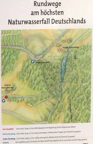
Wanderwege am Wasserfall
Informationen & Fragen zum Cache:
Vor Ort erwarten euch einige Aufgaben.
- Finde heraus, wo die Quelle des Wasserfalls liegt. Wo genau liegt diese? Wie hoch liegt diese? Wie weit weg ist die Quelle vom Wasserfall entfernt?
- Begebe dich zu N 47° 50.525 E 007° 56.075. Du stehst nun am Anfang der Wasserfälle und hast vor dir ein hölzernes Tor und eine Informationstafel. Untersuche die Informationen genau, denn es widerspricht sich hier etwas! Ich möchte von euch wissen was hier genau verkehrt ist!
- Gehe weiter zu N 47° 50.610 E 007° 56.329. Hier findest du eine Holzplattform, die sich Ideal für ein Bild anbietet. Ein Beispielfoto von mir findest du weiter unten. Ein Bild zu machen ist kein Zwang, sondern ist für freiwillige als Erinnerung gedacht!
- Drehe dich nach deinem Fotoshooting um und blicke auf den Wasserfall. Am Fuße siehst du ein weiteres Schild, welches eine besondere Form besitzt. Welche?
- Wie viele Fallstufen hat der Wasserfall?
Schicke die Lösungen und dein Bild (wenn du eines gemacht hast) an  .
.
Gerne kannst du dann neben deinem optionalen Beweisfoto noch weitere Fotos in deinen Log online stellen, bitte aber dabei nicht die Aufgaben spoilern!
Du kannst direkt loggen, bei Problemen melde ich mich.
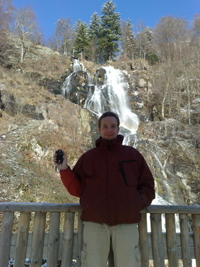
Beispielfoto: billyxx vor dem Wasserfall
Springe zur deutschen Version

Index English
The waterfall near Todtnau is with its 97 meters the highest natural waterfall in Germany. The water of the Stübenbach falls over several cascades into the depth between Todtnauberg and Aftersteg. If you visit this location it is an experience, no matter which season you chose. In summertime the water is being whirled up by the rock and offers fresh and wet air to cool down. During wintertime there are often bizarre ice formations beside the waterfall.
Bizarre ice formations at the bridge railing
The natural waterfall has landmark status since 1987 and belongs to the most famous natural monuments of Germany. If you want to visit the waterfalls you have different possibilities. The first one is to start at Todtnauberg, the second begins at Aftersteg. Here you have a small kiosk and a huge parking area. The third possibility is to start from Todtnau in the upper Wiesental. There is a romantic route with bridges and staircases which leads along the falls.
The main waterfall

Evolution of the waterfall:
The waterfall of Todtnau has its origin throughout the last glacier period. The main reason has been the power of erosion of the ice nearby a geological distortion (a breaking line). More than 11.000 years ago the ice flossed from the high valley of Todtnauberg into the main glacier of Wiesental. With about 500 meters this glacier engraved the valley of Wiesental much more than the glacier of Stübenbach engraved the valley of Todtnauberg. The result is a huge difference in the altitude. When the glacier melted, a so called "hanging valley" came into existance between Todtnauberg and Todtnau. Today the outlet of the hanging valley is the beginning of the waterfall of Todtnau, where the Stübenbach falls into the depth.
The erosional power of the water will need millions of years to flatten this gorgeous natural play.
Additional Information about the waterfall:
In the 18th century this area was very important for mining. A lot of silver ore was found here. The whole massif is crossed by tunnels for mining.
The waterfall belongs to the 10 most beautiful natural monuments of Germany. More than 500.000 guests visit this unique natural play each year. During wintertime the waterfall freezes to the bizarre figures of oversized ice taps. The huge number of visitors is very important for the tourism industry of the region.
If you start your walk to the waterfall at the kiosk and keep on walking for approximately 200 m towards the waterfall you will find another natural monument on the left hand : A 300 years old beech. During a lot of centuries this tree was characterized by wind and weather. I promise you that you will be fascinated from the first moment you see this beech! You can barely imagine what this plant has gone through during this long period of time!
If you go from the upper drop stage 300 meters to the east you will find the "treasure stone". There are a lot of myths concerning this monolith. Even today the secrets of the hieroglyphics hewn in stone are not yet encrypted! Perhaps you will be the first one to do so?
Accessibility & Walking possibilities :
The waterfall is easy accessible by using well marked hiking trails. There are three different possibilities offered to you:
- walk from Todtnau (Church) via Sonnhalde -> waterfall
- walk from Aftersteg (big parking area nearby the street "L 126 Todtnau-Freiburg") crossing the kiosk "waterfall" with a huge beer garden -> waterfall
- walk from Todtnauberg via Schwimmbadweg or via town center -> waterfall
Beside these routes you have the possibility to discover the waterfall by following several well marked circular routes. You will travel about 3,5 km in distance and cover an altitude of about 150 meters. The first possibility is to start near the first exercise (N 47° 50.525 E 007° 56.075). Your second option is to start from Todtnauberg at the "Hangloch" (N 47° 50.638 E 007° 56.178). Both starting-positions have parking areas and some signs, which give you more information about the waterfall.
Walking possibilities at the waterfall
Information & tasks for the cache:
I would like you to perform the following tasks:
- Try to locate the spring of the waterfall. Where is it? How high is the spring? How far away is the spring?
- Please go to N 47° 50.525 E 007° 56.075. You reached the beginning of the waterfall. In front of you there is a wooden gate and a sign with some information about the waterfall. Please read these information carefully because there is a contradicting content! I want to know what exactly is wrong!
- Continue your trip to N 47° 50.610 E 007° 56.329. You will find a wooden platform. This platform is ideal for taking a nice picture. If you are already on site take a picture showing yourself, your GPSr and the waterfall (see example photo below)! Taking a picture is voluntary!
- If you have finished your fotoshooting please turn around and look to the waterfall. At the bottom you will see another sign. It has a special form. What kind of form do you see?
- How many steps does the waterfall have?
Send your answers and your image (if you took an image) to .
Feel free to add some additional photos beside your voluntary picture in front of the spring to your online log as long as you are not spoiling any of the tasks!
You can log your visit directly, if there are any problems I will contact you.
Example photo: billyxx in front of the waterfall
Happy Hunting wünscht