Gellért Hill cliffs EarthCache
-
Difficulty:
-

-
Terrain:
-

Size:  (other)
Please note Use of geocaching.com services is subject to the terms and conditions
in our disclaimer.
Territory of the protected area: 40 hectares.
Location: The protected area is situated in the central area of Budapest at the Buda side of Erzsébet bridge.
Visitors: Free of access for visitors.
Management: Directorate of the Duna–Ipoly National Park
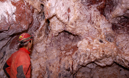
The 139 m tall Gellért-hill with its characteristic form towering over the Danube is one of the most well-known sights of Hungary, but much less is known about its real values. The 235 m tall dolomite mountain is the most renowned member of the chain of mountains (the Sas mountain, the Törökugrató also belong there) in southern Buda, the dolomite of which called 'main dolomite' formed in the upper Triassic and got elevated and broken up in the Pleistocene. It was in the Eocene that limestone got deposited onto the dolomite (it is still visible at the southwestern foot of the Citadella), then in the course of elevation thermal water activities resulted some travertine formations in the area (it can be spotted on the south eastern slopes). The caves of the Gellért-hill got formed along the thermal faults. The most famous is perhaps the Szent Iván cave (N 47° 29.087 E 019° 03.134), which houses a chapel of the Pauline order. There are several active springs in the mountain (Árpád-, Mátyás-, Rákóczi- etc.) and medicinal thermal baths at the foot (Rác-, Gellért-, Rudas-baths), which are also the result of this hydrogeologic process. The fauna of the popular mountain in the center of the capital is far from being natural, as the majority of its area is a public park. Still, some fragments of lime-ash remnant forests, karst scrubforests and hornbeam-oaks and – mainly on the west side – Tatarian maple-loess-oaks are recognizable. It is even more interesting, that smaller stands of open and closed dolomite puszta lawns have survived on the eastern steep rocky side, with such valuable protected plants as the (Paronychia cephalotes), the sea grape (Ephedra distachya), or the sadler imola (Centaurea sadleriana) and the hare's tail grass. The (Silene flavescens) lives only here in Hungary.
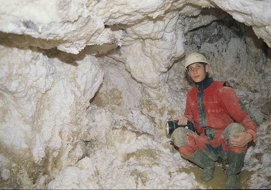
In January 2007 a new cave was discovered under Gellért Hill during a private construction. The cave is 60 m long and 18 m deep with 3 rooms. The interior is covered with dazzling white crystals composed of gypsum, calcite and aragonite. The cave was created 300-500,000 years ago by a now disappeared thermal spring. The crystal cave was immediately placed under legal protection. (Bérc street 4a - no visible)
Dolomite is the name of a sedimentary carbonate rock and a mineral, both composed of calcium magnesium carbonate CaMg(CO3)2 found in crystals.
Dolomite rock (also dolostone) is composed predominantly of the mineral dolomite. Limestone that is partially replaced by dolomite is referred to as dolomitic limestone, or in old U.S. geologic literature as magnesian limestone. Dolomite was first described in 1791 as the rock by the French naturalist and geologist, Déodat Gratet de Dolomieu (1750–1801) for exposures in the Dolomite Alps of northern Italy.
The Gellért Hill description for details (Hungarian, English, German, Italian, Spanish).
To log yor visit, please.
Send your answers via e-mail to me...
Please don’t give answers in your log !
1, What is the density of dolomite ?
2, What is the hardness of dolomite ?
3, Year of the measuring point, on the waypoint (N 47° 29.233 E 019° 02.936) ?
If you want you can upload a photo with you and/or your GPS from the header coordinates, the Szabadság híd (green bridge) in the background.
Free Hungarian GPS unit digital map means 'hiking trail' (túristatérkép) program from here downloadable.
-----------------------------------------------------------------------
A védett terület nagysága: 40 hektár.
Elhelyezkedés: A védett terület Budapest belterületén, az Erzsébet híd budai hídfojénél található.
Látogatás: Szabadon látogatható.
Kezelo: Duna–Ipoly Nemzeti Park Igazgatóság
A Gellért-hegyet valószínuleg senkinek nem kell bemutatni, hiszen a 139 méterrel a Duna fölé magasodó, jellegzetes formájú hegy Magyarország egyik legismertebb látványa – ám, ahogy ez lenni szokott, valódi értékeirol már sokkal kevesebbet tudunk. A 235 méter magas dolomithegy annak a délbudai láncnak a leghíresebb tagja (ide tartozik pl. a Sashegy, a Törökugrató stb. is), amelynek dolomitja a felso triászban képzodött ún. födolomit, de hegyei késobb, a pleisztocén során emelkedtek ki, és töredeztek össze. Az eocénban a dolomitra mészko ülepedett (kis területen, a Citadella délnyugati lábánál még megfigyelheto), majd a pleisztocén kori kiemelkedés során a hévizes tevékenység miatt forrásvízi mészko képzodött a területen (a délkeleti lejtokön felfedezheto). A Gellért-hegy barlangjai is a törések melegvizes kioldódásai mentén jöttek létre. Talán a leghíresebb, a részben mesterségesen tovább bovített Szent Iván-barlang (N 47° 29.087 E 019° 03.134), ami a pálos rend kápolnájának ad otthont. A hegyen sok máig muködo forrás található (Árpád-, Mátyás-, Rákóczi- stb.) és a hegylábaknál muködo értékes gyógyfürdok (a Rác-, a Gellért- és a Rudas-fürdo) is ennek a hidrogeológiai folyamatnak köszönhetik létüket. A fováros közepén található és igen látogatott hegy növényzete már korántsem természetes, hiszen a terület nagy része közparkként muködik. Egyes félreeso részeken mégis felismerhetok a hárs-koris törmelékerdok, a karsztbokorerdok és a gyertyános-tölgyesek, illetve – elsosorban a nyugati oldalon – a tatárjuharos lösztölgyes maradványai. Ami még ennél is nagyobb szenzáció, hogy a meredek, sziklás keleti részeken még fennmaradtak a nyílt és zárt dolomitsziklagyep kisebb állományai, olyan értékes, védett növényekkel, mint az ezüstaszott (Paronychia cephalotes), a csikófark (Ephedra distachya) vagy a budai imola és a nyúlfarkfu – valamint a legnagyobb kincs, a Magyarországon csak itt élö sárgás habszegfü. Az egykor a boszorkányok hegyeként tisztelt és sokak szerint mágikus erovel bíró Gellért-hegy történelmi, kultúrtörténeti értékei vetekednek természeti értékével – elég csak Szent Gellért püspök vagy az osztrákok által épített erod, a Citadella történetére gondolni.
2007 januárjában hatvan méter hosszú, tizennyolc méter mély kristálybarlangot talált egy magyar geológuscsoport a Citadella közelében, a Gellért-hegy alatt. A Gellért-hegy csak korlátozottan alkalmas a barlangképzodésre, így igen nagy szenzáció a csillogó fehér kövekkel borított barlang. (Bérc utca 4a - nem látható)
A dolomit (barnapát, gyöngypát) egy ásvány, melynek képlete CaMg(CO3)2. Dolomit névvel illetjük az ebbol az ásványból álló karbonátos kozetet is
A dolomit olyan közet, amelynek több mint 90%-a dolomit ásvány. Magyarországon több változata ismert (födolomit, diploporás dolomit) helyenként erosen porlik; a szétesés eredménye a dolomitmurva, végso stádiumában a dolomithomok. Porlás közben a kozetet átjáró kovás erek kipreparálódnak, majd szétesnek; visszamaradó anyaguk az úgynevezett úszó kvarc.
A Gellért Hegy ismertetése bovebben (Magyarul, Angolul, Németül, Olaszul, Spanyolul).
A logoláshoz kérlek…
Küldd el a válaszokat számomra e-mailben...
Kérlek, ne adj meg választ a logban !
1, Mennyi a surusége dolomitnak ?
2, Mekkora a keménysége a dolomitnak ?
3, A mérési pont évszáma, a segédponton (N 47° 29.233 E 019° 02.936) ?
Ha van kedved tölts fel fotót magadról és/vagy a GPS-edrol, a megadott koordinátákon, a Szabadság híddal (zöld híd) a háttérben !

Additional Hints
(Decrypt)
[ ENG : ] Veba gnoyr qverpgyl orfvqr gur cngu ( S16 )
[ HUN : ] Inf gáoyn xömirgyraüy nm öfiéal zryyrgg ( S16 )