Oakfield Ledge EarthCache
-
Difficulty:
-

-
Terrain:
-

Size:  (not chosen)
Related Web Page
Please note Use of geocaching.com services is subject to the terms and conditions
in our disclaimer.
An EarthCache adventure is treasure hunting for the caches that the Earth has stored. EarthCache sites do not use stored containers; their treasure is the lessons people learn about our planet when they visit the site. Visitors to EarthCache sites can see how our planet has been shaped by geological processes, how we manage the resources and how scientists gather evidence to learn about the Earth.

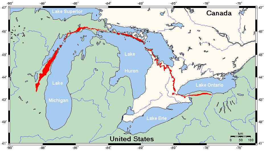
The Niagara Escarpment, locally called, "the Ledge", is a layer of bedrock made up of limestone cliffs and talus slopes. It hugs the eastern edge of Horicon Marsh and extends further south to the town of Iron Ridge and the Neda mines. South of the mines, it disappears as a surface feature, buried by glacial deposits. To the north of Horicon Marsh, it reaches into the town of Oakfield and continues all along the eastern shore of Lake Winnebago to Green Bay and Door County. Overall, in Wisconsin the Niagara Escarpment extends for a distance of 230 miles.
It continues north/northeast as an underwater and subsurface feature. It bends underneath Lake Michigan, the state of Michigan, Lakes Huron and Erie, appearing again as a surface feature at Niagara Falls in New York. In other words, the same layer of rock which forms our hills on the east side of the marsh extends 500 miles to the east and is the same rock layer that the Niagara River plunges over to form Niagara Falls. Here in eastern Wisconsin, we live, work, and play on the back side of Niagara Falls!
From New York, the Niagara Escarpment (part of the Michigan Basin) runs through the Appalachian Mountains, goes south into Pennsylvania, Ohio, and Indiana, and meanders back through Illinois, Wisconsin, to West Union, Iowa. It extends north and west into Canada as well. It is like a giant saucer with the western edge in Wisconsin and eastern edge in New York.
The Ledge rises up to 200 feet high, but the maximum thickness of this rock layer is 450 to 800 feet depending upon the location. The Ledge's material (dolomitic limestone) is at least 400 million years old. In comparison, the Appalachians are about 300 million years old and the Rocky Mountains, about 70 million. However, the Ledge can be considered even younger because it was reformed at its current location by the last glacier, which receded from this area about 12,000 years ago.
The endurance of the Ledge is attributed to the erosion-resistant material which forms it. It is made of Silurian limestones and dolomites. Dolomite, the main ingredient, was formed by calcium and magnesium carbonate deposited from decomposing shells and skeletons of primitive sea life which lived in a subtropical coral reef during the Silurian age (over 400 million years ago). So, the Niagara Escarpment was once the edge of a coral reef formed in the warm, clear, shallow, salt waters at the edge of the giant Michigan basin. At the time, this ancient inland sea's basin covered all of what is now lower Michigan, Lake Michigan and eastern Wisconsin.
As the Paleozoic Era (600 to 280 million years ago) proceeded, each new layer of sediment was deposited, causing the basin to gradually sink in the middle, and form the sedimentary rock that we see in the Ledge today. Some rock layers are composed of eroded material, others are made of limy material, remnants of marine life. The shallow seas slowly evaporated leaving behind thick deposits of gypsum and salt, the weight of which caused the crust to sink even more. A process called reflux filled the basin many more times, only to evaporate each time in the subtropical sun. Under what is now Michigan and Lakes Huron, Erie, and Michigan, the Niagara Escarpment subsided, causing an upwarping or bending of the bedrock near its margins. The edges of this material were forced to the surface, forming an escarpment at each end (in Wisconsin and New York). When the ancient seas receded, these rock edges were exposed. Most weathered away, but the Ledge kept its cliff edge.
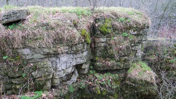
A layer of soft, impermeable layer called Maquoketa shale lies beneath the Ledge. It was formed during the Ordovician Period (about 500 million years ago) by great thicknesses of mud which washed in due to erosion from the Appalachian Mountains as they rose to the east. Today, the shale erodes quickly where it is exposed, allowing the dolomite to continually break off and form a new cliff face. This process can be measured at Niagara Falls in miles per century. It is in part because of this relatively soft shale layer that Horicon Marsh was later formed by glacial action.
It is also in part because of this impermeable shale bed that many crystal-clear springs form at the base of the Ledge. Fed by precipitation, water flows down slope at and beneath the surface of the Ledge through the dolomite, which is highly fractured into perpendicular horizontal and vertical joints. Springs form at the base of the Ledge where glaciers deposited drift consisting in part of impermeable clays. Water flow continues on to eventually drain into Horicon Marsh or Lake Winnebago.
Fossils found on the Ledge include brachiopods, cephalopods, crinoids, and corals. They represent creatures that lived in the sea which deposited the materials in the Ledge. Trilobite fossils (Wisconsin's state fossil) are abundant in some old quarries. Part of a giant squid-like fossil found in a Mayville quarry is more than 33 feet long based on comparison to modern squids. Various rocks like calcite crystals, and garnet have also been found.
Evidence of the oldest known humans living in Wisconsin has been found on the Oakfield Ledge: a projectile point over 11,200 years old. The Ledge near Horicon Marsh on up to Fond du Lac is an apparent significant site for religious ceremonies, navigational landmarks, and astronomical observations for ancient Native Americans, still visited today. Sites along it contain petroglyphs (Native American rock art) and markings associated with the solstices and possibly the lunar cycle.
The Ledge was first mapped as a prominent land feature in 1836 by a United States Government land surveyor as part of the Wisconsin Territory Survey.
In Wisconsin alone, the Niagara Escarpment is the home to the most underground caves in the state, the largest bat hibernacula in the Midwest, the 2nd oldest native forest in North America, thousands of springs, seeps and vernal pools, seven waterfalls and even some white cedar trees more than 1000 years old.
The Wisconsin Department of Natural Resources is striving to preserve the Oakfield Ledge. This is a DNR State Natural Area. Please stay on the public trail. NO rock climbing and NO collecting of plants (including fruits, nuts, or edible plant parts), animals, fungi, rocks, minerals, fossils, archaeological artifacts, soil, downed wood, or any other natural material, alive or dead.
Walk on the trail heading North from the posted (parking lot) coordinates. PLEASE BE CAREFUL. The stones can be slippery and there is NO fence or railing along the ridge. Send your answers regarding man’s current use of this geological formation to the cache owner (NOT in your “Found It” log):
1) Somewhat Obvious: Dolomite limestone is known for its hardness, durability, level beds, colors, textures, and superior compressive strength. What type of business is found nearby that takes advantage of this? If you hadn’t noticed on the way in, look in the distance to the SSE of the parking lot.
2) Less Obvious: Wisconsin isn't the best state for wind, but the areas along the Niagara Escarpment offer some of the highest average speeds in Wisconsin. In nearby Byron, for example, the Niagara Escarpment is about 300 feet higher than the land to the north and west. As winds blow across the area, the escarpment forces them up, which increases their speed. What type of business takes advantage of this? How do they do this?
Voluntary (no longer a requirement): In your “Found It” log, please include photographs of the rock formations of the Escarpment.
DISCLAIMER: I am not an Earthcache expert, but I do enjoy finding and creating Earthcaches. The information I present is not my own. For this Earthcache, the majority of the information came from links found at the Niagara Escarpment Resource Network website.
Additional Hints
(No hints available.)