Due to technical problems, please do not use the message center to send the solutions. I will no longer answer that. Better options are given for the questions.
Pinnacles
|
|
Fraser Island has a length of about 120 kilometres. The island is considered to be the largest sand island in the world at 1840 km². It was inscribed as a World Heritage site in 1992.
About 700 million years ago Antarctica had mountain ranges that rival the modern-day Himalayas. These mountain ranges, f.e. the Great Dividing Range along the East Coast of Australia, were eroded with the resulting sands being accumulated on the continental shelf where Fraser Island now lies.
Periodic changes in the earth's temperature have created changes in sea levels which have helped to form the island. During these periods dune building was at its most prolific with sand sweeping across the island faster than plants could stabilise it. This loose, bare sand formed U or V-shaped parabolic dunes which then stabilised over time.
This dynamic landscape has formed a series of overlapping sand dune systems dating back at least 700 000 years. The shifting sands of Fraser Island, and those of nearby Cooloola, have continually concealed and revealed a unique geological history.
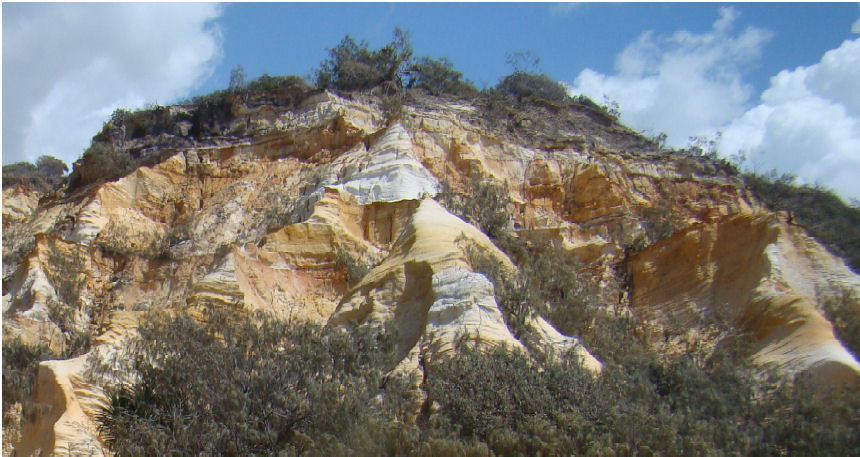
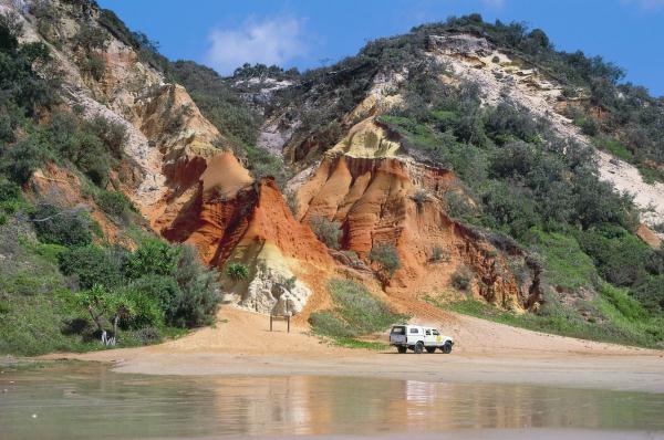
The coloured sands on Fraser Island occur north of Eli Creek and comprise 72 different colours, mostly reds and yellows. Some of the more spectacular features of Fraser Island are its exposed cliffs of coloured sands. Inevitably when groups of people see these stunning exposures they become curious about how they were derived. We know that the red/orange colouring agent is iron in various intensities.
A film of iron compounds (sesqui-oxides) encapsulate many of the grains of silica sand. These oxides over time get stripped off the surface layers. The organic acids derived from plant detritus accelerate this process. The stripped iron oxides are deposited in the lower levels of the soil and build up both concentrations of colour and nutrient in the “B” horizon of the evolving podzol soil. The deeper down in the soil profile usually the greater the thickness of the “B” horizon and its richness in colour are. However there is usually no sharp division between the white “A” horizon and the deeper yellow to pale orange “B” horizon.
(Taken from: The Mystery of the bands in Fraser Island’s Coloured Sands)
|
| Task 1 : |
What is the height above sea level of the highest point of Frazer Island? |
| Task 2 : |
Estimate the thickness of the bottom white “A” horizon and the deeper yellow to pale orange “B” horizon. |
| Task 3 : |
Pictures of you or your GPS at Fraser Island’s Coloured Sands are welcome. |
| |
|
|
|
Send me the answers to the questions above with this form or by e-mail.  zu. Please do not use the message center, otherwise it may not be possible for you to receive my answer. zu. Please do not use the message center, otherwise it may not be possible for you to receive my answer.
If groups have addressed this cache, all cache names must be specified or each logger must submit the solutions individually.
After submitting the answers, you can log immediately. I get in touch, not just when something is wrong.
|
|
Special regard has to be taken for the environment in this National Park which is totally protected. You must comply with any park regulations.
We recommend you browsing on http://www.derm.qld.gov.au/parks/fraser/index.html.

|