 Hot Springs National Park has a rich history. The park has prehistoric American Indian novaculite quarries. It was the destination of the Dunbar-Hunter Expedition sent by President Jefferson in 1804. A bustling town grew up around the hot springs to provide services for health seekers. Central to the American Spa was the bathing industry. The Public Health Service Clinic that was in conjunction with the Government Free Bathhouse was one of the first facilities in the United States to use penicillin.
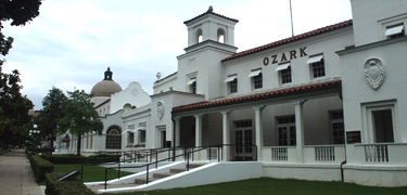
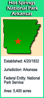
Known as the "the Valley of the Vapors" by Native Americans for centuries long before being "discovered" by European settlers, the Hot Springs area is thought to have been a peaceful location where tribes came together to enjoy the waters. It first came to the attention of others in 1541 when explorer Hernando DeSoto and his group ventured into the area. Over the next few hundred years, the area experienced little change as it passed under the control of both Spain and France, to be finally ceded to the United States as part of the vast Louisiana Purchase in 1803. Slowly the area began to draw visitors as they came to experience the "healing powers" of the hot springs. Then, in 1832, 12 years after the Arkansas Territorial Legislature had requested it, the United States Congress officially set aside the land as a reservation area giving it federal protection. This marked the first time the US Government had reserved part of the country for public use, with the intent to prevent its destruction or abuse by private individuals.  The next few decades found the area both enjoyed and yes, abused, by those interested in its benefits and the people who wanted to get rich off of them. Hot spring water (which averaged 143 degrees) was diverted and directed to several bathhouses which where constructed to provide a place for paying customers to enjoy the water, after it had been cooled some. In 1877, the federal government started exercising control over the area and initiated the process of both cleaning it up and preserving it for future generations. Bathhouses were still allowed, but the government controlled water flows with a plumbing system it created. It even got in the bathhouse business itself, offering free baths to the poor and later building the Army and Navy General Hospital. Hot Springs remained a reservation area until 1921, when Congress officially renamed it Hot Springs National Park. It eventually came to encompass over 5,000 acres including the surrounding hillsides. Baths are still offered by local businesses which utilize the hot springs water that they purchase from the Park.
The Geocache Notification Form has been submitted to The Glacial Drumlin Trail office in Lake Mills, of the Wisconsin DNR. Geocaches placed on Wisconsin Department of Natural Resource managed lands require permission by means of a notification form. Please print out a paper copy of the notification form, fill in all required information, then submit it to the land manager. The DNR Notification form and land manager information can be obtained at: http://www.wi-geocaching.com/hiding