Weinheimer-Trift EarthCache
-
Difficulty:
-

-
Terrain:
-

Size:  (other)
Please note Use of geocaching.com services is subject to the terms and conditions
in our disclaimer.

 Deutsch: |
|
Das Geotop bei Alzey-Weinheim zeigt Ablagerungen des Meeres aus der Zeit des Tertiär (Oligozän) vor 30 Millionen Jahren.
Vor etwa 30 Millionen Jahren, im sogenannten Oligozän, war das Tal von Weinheim eine Bucht an der Ostküste einer großen Halbinsel. Damals hatte das Meer das Mainzer Becken überflutet und es herrschte ein wärmeres Klima. Die Trift gibt einen Einblick in den Meeresboden zu dieser Zeit. Der Sand ist ein Abtragungsprodukt der ca. 280 Millionen Jahre alten Gesteine der damaligen Küste. Das Sediment der Trift besteht aus fein- bis grobkörnigen Sanden, teilweise mit unterschiedlich hohem Feinkiesanteil.
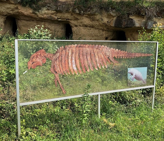
Die häufigsten Fossilien sind Muscheln und Schnecken, die als weißliche Objekte in der Wand erkennbar sind. Außerdem enthält das Gestein Fischreste, vor allem Haifischzähne, Seekuhknochen und Überreste mikroskopisch kleiner Tiere und Pflanzen. Es handelt sich hier um eines der artenreichsten Vorkommen in den Küstensedimenten des Mainzer Beckens. Im mittleren Abschnitt der Wand wittern im höheren Bereich knotenartige Strukturen heraus. Es handelt sich um nachträglich verfüllte Gänge von im Meeresboden grabenden Tieren wie z.B. Krebsen und Würmern. Außerdem fallen im feinkörnigen Sediment U- bis halbkreisförmige Grobsand- bis Feinkies-Anreicherungen auf, die von Rochen auf Nahrungssuche stammen. Nach der Ablagerung der Sande kam es unter bestimmten Voraussetzungen zu Kalkausfüllungen, die einzelne Schichten brotlaibförmig bzw. bankartig verkittet haben, so dass sie stärker herauswittern.
Die Trift ist seit mehr als 150 Jahren Anziehungspunkt für Geologen und Paläontologen. Viele naturhistorische Museen besitzen Fossilien aus Weinheim.
Die Höhlen an der Basis der Steilwand wurden im Zweiten Weltkrieg angelegt und dienten als Zufluchtsort vor Luftangriffen.
Um den Weg zur Trift zu finden, folgt in Weinheim den grünen Schildern "Naturdenkmal Trift".
Zusätzlicher Hinweis: Bitte respektiert den Zaun, der die Trift schützen soll, und die "Privatgrundstück"-Schilder in der Umgebung. Danke!
Um den Cache als Fund zu loggen sendet bitte eine eMail an mich mit der Antwort auf folgende Fragen:
1.) Was sind die häufigsten Fossilien die hier vorkommen?
2.) Aus welcher Zeit stammen diese Fossilien? (Name und Zahl)
Optional: Wenn möglich hängt bitte eine Foto an das Log welches Euch mit dem GPS in der Hand vor der Weinheimer Trift zeigt.
Nachdem Ihr Eure Antworten geschickt habt könnt Ihr Euren Besuch sofort online loggen (wartet nicht auf meine Bestätigung). Sollten Eure Antworten nicht korrekt sein dann melde ich mich schon, Logs ohne Mail mit den Lösungen muss ich leider wieder löschen.
Viel Spaß
Schlauwiner
|
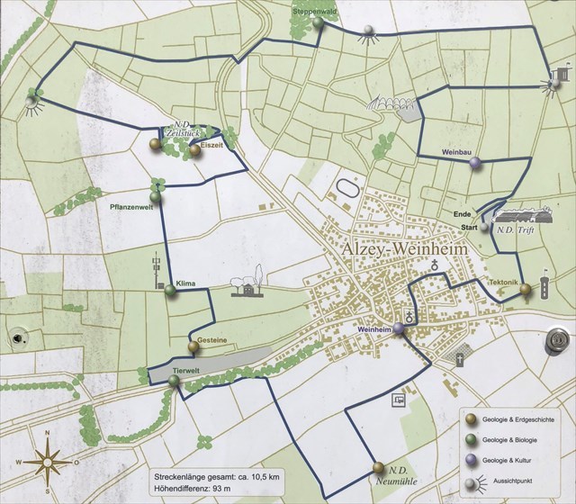
Wanderroute / hike path:
 English: |
|
This geological site in Alzey-Weinheim displays sediments of the sea from the tertiary period (oligocene) some 30 million years ago.
About 30 million years ago, in the so called oligocene, the valley of Weinheim was a bay on the east coast of a peninsula. In those times the sea had flooded most of the land southwest of Mayence (Mainz) and the climate was much warmer. At the "Trift" you can see what the ground of the sea looked like. The sand has been washed away from the 280 million years old rocks of the nearby shores.
The most common fossils are mussels and snails, which you can see as white objects in the sand wall. There are also remains of fish, especially shark's teeth, bones of manatees, and remains of small animals and plants. In the middle part of the wall there are knot-like structures which are holes, digged by animals like crayfish and worms, and filled up with different material afterwards. In the close-grained sediment you can see clearly U-shaped concentrations of coarse sand and fine gravel, which were made by rays searching for food.
After the sand had settled, lime precipitation came about in certain circumstances and grouted the layers, so they are more likely to weather out.
The "Trift" has attracted geologists and paleontologists for more than 150 years. Many natural history museums have fossils from here. The caves in the lower part of the wall were made in WWII and used as air raid shelter.
To find your way to the "Trift" after your arrival in Weinheim follow the green signs "Naturdenkmal Trift".
Additional note: Please respect the fences that protect the sand walls of the Trift and also the private property (signs saying "Privatgrundstück, betreten verboten!") next to the site. Thank you!
To log your find please answer me the following (by email):
1.) What are the most frequent fossils those occur here?
2.) From which time do these fossils originate? (name and number)
If possible please attach a picture of you, you’re GPS taken with the Weinheimer Trift in the background to proof you visited the site.
You can log immediately your visit online after having sent the answers. It is not necessary to wait for my confirmation as I'll contact you in case there are errors in your answers. Should you log without sending me an answer I'll have to delete your log.
Enjoy
Schlauwiner
|
Seekuh / Manatee:
Wand / wall:


Additional Hints
(No hints available.)