PLEASE
READ THE CACHE PAGE BEFORE ATTEMPTING!
This is the Lair of the
Three-Headed Woman! At this site you are able to claim find to one
of my favorite caches (Lair of the Three-Headed Woman,
GCR71H).
Park
hours are daylight to 11pm. Click
here for additional information on Crosby Farm Regional
Park.
This is an Earthcache, so no physical cache is at this location.
You will need to visit this location to complete the cache
requirements though. I have rated this a 4 star terrain as a result
of the vertical hike and also the risk at the edge of the cliff.
Please watch your children if you bring them.
Erosion is the process of moving or displacing solids (for example:
soil, rock, or other materials) by agents such as wind, water, ice,
or downward movement of organic material such as soil due to
gravity’s force on the material. (An example of this was the
new canyon formed on the north slope of Mt. St. Helens when it
erupted in May 1980 due to the rockslide of rock and ice.) Think
how long it took in this spot alone to cause this much erosion.
Think about how much time and water it took to create what you are
looking at today.
The rate of erosion depends on many factors including how much and
the intensity of rain, the type and texture of the soil, the
gradient of the slope, and how fast the water is moving in the
stream. Other factors would include sediment like small rocks would
increase the rate of erosion.
Here at the posted coordinates you will see massive evidence of
erosion as a result of the water from the culvert. Walk closer to
the edge (be very careful as the water may have eroded support
under the edge) and observe the erosive powers of water as it has
dislodged a large amount of soil and sediment in this spot.
Requirements to log this cache:
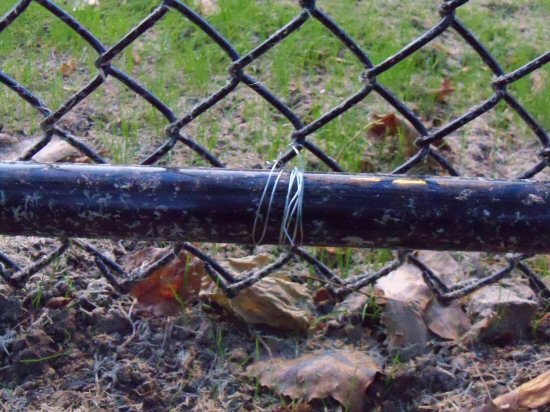
1) Looking at the fence by the culvert, you will see a wire
attached to the fence pole, safely measure distance from the fence
where the wire is located to the edge of the cliff. What is the
measurement?
**REMEMBER TO BRING A TAPE
MEASURE**
Be careful at the
edge as the ground below might not be safe.
Please see the photo below of the wire as that is what you are
looking for.
2) Using your GPS at the top of the cliff what is the
elevation here?
3) Travel to the bottom of the lair and using your GPS, what is the
elevation at the bottom?
4) What is the ground made of that is being eroded?
5) What are some things that could be done to prevent further
erosion?
6) (Requested not required) Post a photo of you and / or your group
at the bottom of the lair showing the lair in the background and
attach it to your log.
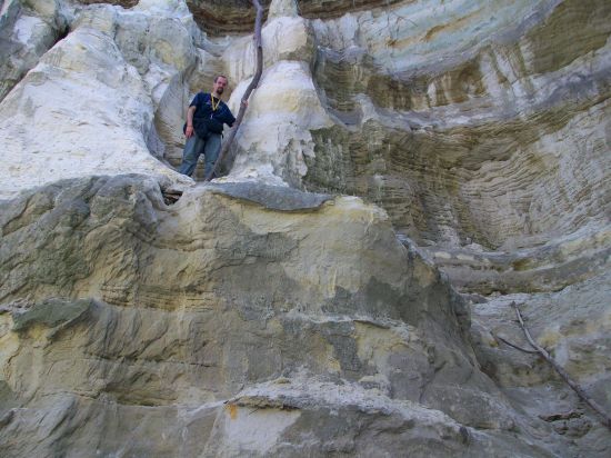
Please note, you can stay at ground level and do not need
to climb!
Email me the answers to
the questions using my profile.
Each Cacher that logs a find is required to submit answers to the
questions above (failure to comply will result in a deletion of
your log). The only exception to this are young kids that are
caching with their parents (who have their own account, but not
computer privileges). Per Earthcache guidelines, each cacher is to
learn from their visit / experience. That means each cacher must
perform the necessary task(s) or requirements to log the cache and
earn your smiley.
Any logs that do not
meet the above posted requirements will be deleted at the
discretion of the cache owner. All logging requirements must be
completed within 48 hours of logging the cache online or your log
will be deleted unless you have prior permission from the cache
owner.