M-C-G staat voor Maarkels Cachers Gilde. Een samenwerking van
drie teams, allen uit Markelo. Doel van dit Gilde is om Markelo
definitief op de cachers kaart te zetten. Deze serie bestaat uit 13
caches met als afsluiting natuurlijk een bonus. We hebben veel tijd
en energie gestoken in de caches en denken dat jullie gaan genieten
van bijzondere plekjes in dit prachtige dorpje. Meer informatie is
te vinden op WWW.M-C-G.nl
In Zuid Twente, nabij Goor, ligt een bijzonder gebied. Dit
gebied, tussen landgoed Weldam en de Herikerberg, vormt een
essentiële schakel tussen de verschillende natuurgebieden in
Duitsland en de Sallandse heuvelrug. Het bevatte echter allerlei
obstakels voor dieren die er hun weg zochten. Daarom is het gebied
in de periode 1998-200 toegankelijker gemaakt voor dieren en is een
ecologische verbindindingszone gerealiseerd. De herinrichting is
tot stand gekomen door een bijzondere samenwerking tussen
waterbedrijf Vitens, provincie Overijssel, Landschap Overijssel,
waterschap Regge & Dinkel, landgoed Weldam, gemeente Hof van
Twente, Rijkswaterstaat, NS vastgoed en diverse particulieren.
Ecologische verbindingszone
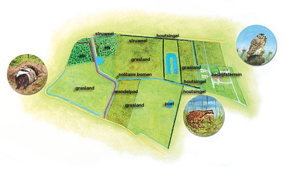
Een ecologische verbindingszone is een zone die verschillende
(natuur)gebieden met elkaar verbindt en er voor zorgt dat deze
gebieden een samenhangend geheel vormen. Het doel hiervan is dat
met name zoogdieren en amfibieën zich ongestoord van het ene gebied
naar het andere gebied kunnen verplaatsten, zodat ze altijd
voldoende voedsel, water, rust en beschutting kunnen vinden. Om dit
te vergemakkelijken zijn in de ecologische verbindingszone
Weldam-Herikerberg diverse maatregelen uitgevoerd. Zo is er
beplanting langs beken aangelegd, zijn er boscomplexen aangelegd en
uitgebreid en is een faunatunnel onder de weg aangelegd.
Educatieve grondwatermeter
Water is onmisbaar voor mens, plant en dier! Gelukkig hebben we
genoeg water in Nederland, zullen veel mensen denken. Maar dat is
niet altijd zo: op sommige plekken is er onvoldoende grondwater
voor natuur en landbouw. Dit kan leiden tot verdroging. De gewenste
grondwaterstand is in elk gebied anders. Diverse organisaties meten
regelmatig wat de grondwaterstand. De peilbuizen van de
profesionele organisaties zijn echter niet toegankelijk voor
publiek. Daarom zijn op diverse locaties in Overijssel
grondwatermeters geplaatst waar iedereen zelf kan aflezen wat de
grondwaterstand is. In een oogopslag is te zien of het grondwater
hoog genoeg staat voor de natuur te plekke. Eén van deze
grondwatermeters staat in het waterwingebied Goor.
Hoe werkt een grondwatermeter

Een grondwatermeter bestaat uit een stalen buis die zich voor
een paar meter onder de grond bevindt. Via gaten onder in de buis
komt het grondwater in de buis te staan. Op dit water drijft een
lange koker die boven de grond te zien is en de stand van het
grondwater aangeeft. De stand van het grondwater wordt altijd
aangegeven vanaf het maaiveld. Het maaiveld is het grensvlak tussen
bodem en lucht (atmosfeer). Staat het grondwater op de hoogte van
het maaiveld, dan vult de koker de hele buis. De koker staat dan
bij het streepje 0. Zakt het water daarna bijvoorbeeld 120 cm dan
staat het grondwater 120 cm onder het maaiveld. Dit wordt op de
buis aangegeven als -120. De schaalverdeling is in 3 kleuren
aangegeven. Deze kleuren geven aan of de waterstand op peil is, te
laag of veel te laag.
De Cache en de bonus
Ga naar N52.13.847 E 006.34.273 hier vind je meerdere
informatieborden. Om de cache te kunnen loggen moet u de volgende
vragen beantwoorden en mailen naar ons. mail4mcg@gmail.com Een foto van de
hoogte van de grondwaterstand is een optie.
Vraag 1 Op welke diepte wordt hier water uit de bodem gepompt
Vraag 2 Hoeveel Kuub per jaar water wordt hier gewonnen.
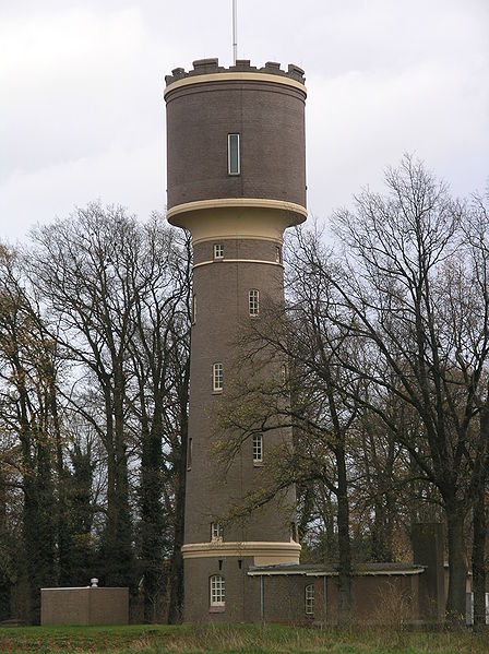
Voor de bonus binnen de M-C-G serie moet je de volgende vraag
beantwoorden: Verderop ziet u een toren, in welk jaartal is de
toren opgeknapt? Stapeltel het jaartal en u heeft het bonuscijfer.
F=
IN ENGLISH
South Twente, near Goor, is a special area. This area, between
the estate and Weldam Herikerberg constitutes an essential link
between the nature areas in Germany and the Salland Ridge. It
contained, however, many obstacles to animals who were looking
their way. Therefore, the area in the period 1998-200 access for
animals and a ecological verbindindingszone realized. The redesign
was created by a special collaboration between water company
Vitens, Overijssel, Overijssel Landscape, water board Regge and
Dinkel, Weldam estate, municipality of Twente, Rijkswaterstaat, NS
real estate and various individuals.
Ecological corridor An ecological connection zone has a
different (natural) areas together and ensures that these areas
form a coherent whole. The aim is that especially mammals and
amphibians unhindered from one area to another area to move, so
they always have enough food, water, rest and find shelter. To
facilitate this in the ecological corridor Weldam-Herikerberg
various measures implemented. There is landscaped planting along
streams, forest complexes are built and expanded and is a wildlife
tunnel under the road was built.
Educational groundwater meter Water is essential for humans,
plants and animals! Fortunately we have enough water in the
Netherlands, many people think. But that is not always so: in some
places there is insufficient ground for nature and agriculture.
This can lead to dehydration. The water table is required in each
area differently. Several organizations that regularly measuring
the groundwater. The monitoring wells of the professional
organizations are not open to the public. Therefore, at various
locations in Overijssel groundwater meters placed where everyone
can read what the groundwater is. At a glance to see if the
groundwater is high enough for nature to spot. One of these meters
is in the groundwater catchment Goor.
How does a ground water meter work A groundwater meter consists
of a steel tube which is a few meters below the ground. Through
holes in the pipe below ground water in the tube to stand. At the
water floats a long tube that is visible above the ground and the
state of the groundwater indicates. The state of groundwater is
always indicated from ground level. The ground level is the
interface between soil and air (atmosphere). The groundwater at the
ground level, fill the tube around the tube. The tube is then in
the dash 0. For example, the water level falls after the
groundwater than 120 cm 120 cm below ground level. This is
indicated as -120 on the tube. The scale is shown in 3 colors.
These colors indicate that the water levels is too low or too
low.
Cache and the bonus Go to E 006.34.273 N52.13.847 here's more
informative. To log the cache you must answer the following
questions and mail it to us. mail4mcg@gmail.com A picture of the
level of groundwater is an option. Question 1 In what depth of
water are pumped from the ground Question 2 How many Kuub water per
year from here. For the bonus within the MCG series must have the
following question: Until you see a tower, in which year the tower
was refurbished? Stapeltel the year and you have the bonus number.
F=
