Endmoräne von Hohenwarthe
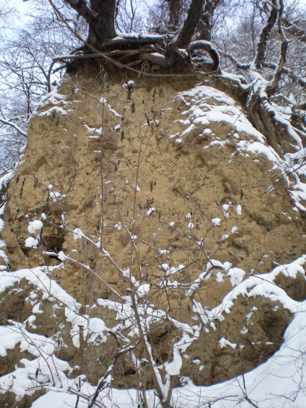
Das Naturschutzgebiet (ca. 40-75m über NN) liegt unmittelbar südlich der Bundesautobahn 2 ca. 1,3 km südlich von Hohenwarthe entfernt. Die Endmoräne (75,5m ü. NN) ein Steilhang an der Elbe, überragt die westelbische Aue um ca. 35m. Endmoränen bildeten sich beim Rückzug der Gletscher und treten als quer gestellte hohe Hügel auf. (bis zu 200m Höhe) Moräne (französisch: "moraine" ) Geröll / Gesteinsschutt, der vom Gletscher mitgeführt und zur Ablagerung gebracht wurde. Bei den Vorstößen der Inlandeisdecke wurde eine gesetzmäßige Landschaft geformt. Beim Verbleib des Inlandeises in einem engen Bereich (mehrere Vorschub- und Abschmelzvorgänge) werden Endmoränen (Satzendmoräne) aufgeschüttet. Es gibt sehr unterschiedliche und komplexe Formen und Typen von Moränen.
Die Landschaft dieser Region wurde von den letzten beiden Eiszeiten, der Saaleeiszeit vor ca. 230.000 bis 130.000 Jahren und der Weichseleiszeit vor ca. 115.000 bis 10.000 Jahren geformt. In den Eiszeiten kam es zu größeren Klimaschwankungen, in denen sich das Eis von Norden kommend nach Süden vorschob und in wärmeren Perioden wieder abschmolz. Der Steilhang wird aus XX und XX der Saalevereisung gebildet. Was an vielen Stellen gut sichtbar ist. (unterer Wanderweg an der Elbe) Sie überlagern am unteren Hangfuß XX (einen wichtigen Leithorizont), der stellenweise aufgeschlossen ist. Der Steilhang schließt ein erdgeschichtlich bedeutendes geologisches Profil auf, welches als Geotop eingetragen ist. Die höher gelegenen Teile der Endmoräne werden von 5-6m mächtigen Sanden und Kiesen bedeckt, die auf den Kuppen Lößauflagen tragen und außerhalb des Naturschuztgebietes ackerbaulich genutzt werden. Auch im nach Süden abfallenden Teil der Endmoräne befinden sich Lößauflagen, die ebenfalls in den abgerutschten Massen am Hangfuß zu finden sind. An mehreren Stellen tritt kristallklares Wasser hervor, welches sich wiederum den Weg in die Elbe sucht. Die Elbe schnitt ihr Tal in die hohe Endmoräne von Hohenwarthe ein, die das Nordwest- Ende des Flämings darstellt.
The nature reserve (approximately 40-75m above sea level) is situated immediately south of the A2 motorway, approximately 1.3km south of Hohenwarthe. The end moraine (75.5m above sea level) is an escarpment along the river Elbe, and towers approximately 35m above the west-Elbe meadows. Moraines formed during the retreat of glaciers and appear as transverse asked high hill. (up to 200m high) moraine (French: "moraine") gravel / rock debrits that was carried by the glacier and taken to the deposit. With the advances of the inland icecover a legitimate landscape was formed. At the whereabouts of the inland ice in a narrow range (several of feed, and processes from melting) are end moraines (set end moraines) heaped. There are many different and complex shapes and types of moraines.
The landscape of this region was of the last two ice ages, formed the Saale ice age, about 230.000 to 130.000 years, and Weichsel ice age, about 115.000 to 10.000 years ago. In the ice ages there were major variations in climate, in which the ice is observed on coming from the north to the south and warmer periods again melted. The escarpment has formed from XX and XX and tills from the Saale glaciation. What is clearly visible in many places. (lower path on the Elbe) At the bottom of the slope, these overlie XX (an important marker horizons), which is sporadically exposed. The escarpment uncloses a geologically significant profile, which is registered as a geotope. The higher parts of the end moraine are covered by 5-6m of mighty sands and gravels. These have loess layers on their peaks, which are used agriculturally outside the limits of the nature reserve. Loess layers are also on the southern slope of the end moraine, and can additionally be found in the slipped-off heaps at the bottom of the slope. In several places in the moraine, crystal clear water emerges, finding its way into the river Elbe. The River Elbe cut a valley into their high end moraine of Hohenwarthe, which is the nordwestern end of the Fläming.
Logbedingungen:
Bei den Koordinaten findet ihr eine Schutzhütte und eine Infotafel.
Bitte beantwortet folgende Frage:
1. Wie entstehen Endmoränen? (Optional)
2. Woraus besteht der Steilhang?
3. Welche Tonart liegt am unteren Hangfuß?
4. Welche Farbe hat der XX-mergel?
Zum Lösen der 4. Frage müßt Ihr Euch auf den unteren Weinbergweg begeben und eine aufgeschlossene Stelle suchen.
Da es keine Pflicht mehr ist ein Foto zumachen, würde ich mich trotzdem über ein Bild von einer interessanten Stelle freuen.
Die Antwort sendet bitte an EC_QRP_Holger@t-online.de oder über meine Profiladresse, danach könnt Ihr sofort loggen.
EC_QRP_Holger@t-online.de
Viel Spaß bei dieser kleinen geologischen Entdeckungsreise
wünscht QRP Holger
Log conditions:
Near the coordinates, you will find a shelter and an information board.
Please answer the following question:
1. How are end moraine? (Optional)
2. What is the steep slope?
3. What kind of clay is at the lower slope foot?
4. What color is the XX tills?
To release the 4th you have to ask you go to the lower vineyard way and looking for a open-minded place.
Since there is no duty more carry on a photo, I still would love a picture of an interesting point.
Please send your answer to my email address below and do not forget to state your GC nickname in the subject line or in the actual message.
EC_QRP_Holger@t-online.de
All the best of fun with this little geology discovery quest
from QRP Holger
Parken kann man bei N 52° 13.201 E011° 42.808
You can park at N 52° 13.201 E011°42.808