Salt de Sallent Traditional Cache
-
Difficulty:
-

-
Terrain:
-

Size:  (small)
Please note Use of geocaching.com services is subject to the terms and conditions
in our disclaimer.
 Català
Cache situat prop del mirador del Salt de Sallent, dins el municipi
de la Vall d'en Bas i prop de la zona privilegiada del Puigsacalm.
Degut a que l'aigua del salt prové d'una riera, la quantitat que en
baixa és molt variable, però val la pena visitar la zona encara que
en baixi molt poca.


Hi ha diferents maneres d'arribar al cache, la què s'explicarà aquí
és una ruta circular
a peu que es pot fer en unes 2 o 3 hores tranquil·lament.
L'aproximació en vehicle fins a l'aparcament es fa travessant Sant
Privat d'en Bas, agafar el trencall a l'esquerra a N 42° 08.939' E
002° 24.537', per seguir la carretera fins a l'aparcament de l'àrea
de picnic dels Pins (N 42° 08.741' E 002° 23.733').
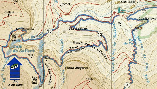
La ruta està ben indicada per cartells, marques i fites. Es comença
a N 42º 08.716' E 002º 23.669', on s'ha de seguir el camí cap al
salt, que en alguns trams sense gaire arbres es pot veure de lluny.
S'han d'anar seguint les indicacions arribant al punt N 42º 08.510'
E 002º 22.649', on s'ha de creuar la riera i comença la pujada pel
camí de Les Escales, que portarà fins a dalt el Salt de Sallent (N
42º 08.483' E 002º 22.522'). Llavors es creua la riera i ser seguir
el mateix camí, per al cap de poc deixar-lo uns metres per anar al
mirador (N 42º 08.446' E 002º 22.564'), on molt a prop hi ha el
cache. Ara cal tornar al camí principal fins a l'indicador de N 42º
08.256' E 002º 22.840', on ara cal deixar el camí ample direcció
"Sant Privat 1h" pel Camí dels Matxos, que porta altre cop a la
zona d'aparcament.

Si es vol aprofitar per anar al cim del Puigsacalm, en comptes
d'agafar el Camí dels Matxos es pot seguir per aquesta ruta
i passar per llocs molt interessants com el Puig dels Llops, Santa
Magdalena del Mont o les Olletes, per tornar altre cop a
l'aparcament.
 English
Cache situated near the viewpoint of Salt de Sallent, in the
municipality of the Vall d'en Bas, near the privileged zone of the
Puigsacalm. Because the waterfall comes from a stream, the quantity
of water that descends is very variable, but it's also advisable to
visit the zone even though there is not too much wate.
There are different ways to arrive to the cache. The ones explained
here is a circular walking route which can be done in 2 o 3 hours.
The approach by vehicle until the parking it has to be done through
Sant Privat d'en Bas, taking the detour to the left in 42° 08.939'
E 002° 24.537', to follow the road until the picnic area parking of
Els Pins (N 42° 08.741' E 002° 23.733').
The route is well marked by posters, marks and milestones. It
begins in N 42° 08.716' E 002 23.669', where it's necessary to take
the way to the waterfall. In some stretches without many trees it's
possible to see it far away. You should follow the marks until N
42° 08.510' E 002° 22.649', where it's necessary to cross the
stream and then begins the rise by Les Escales way which arrives
until the top of the Salt de Sallent (N 42° 08.483' E 002°
22.522'). After that, cross the stream, follow the same way and in
a few meters leave it to go to the viewpoint (N 42º 08.446' E 002º
22.564'), the cache is very near. Then, come back again to the wide
way until the signpost of N 42° 08.256' E 002° 22.840', where you
should leave the wide way to "Sant Privat 1h" direction for the
Camí dels Matxos, where you arrive to the parking zone.
If you also want to go to the Puigsacalm peak, instead of taking
the Camí dels Matxos, it's possible to continue by this route
and pass for interesting places like Puig dels Llops, Santa
Magdalena del Mont or les Olletes, and arriving again to the
parking.
Additional Hints
(Decrypt)
[Català] Rager 2 neoerf, gncng cre crqerf.
[English] Orgjrra 2 gerrf, pbirerq ol fgbarf.