Benvinguts a aquest necessari EarthCache. Vull plantejar aquest EarthCache com un repte en forma d'examen. Per tenir dret a logar cal treure una nota mínima de 5 punts.
Hi ha quatre tasques TOTES OPCIONALS per aconseguir punts.
- Una fotografía (dos punts. Pot fer arribar la puntuació a 10 punts)
- Una pregunta 'de camp' (2 punts)
- Quatre preguntes 'd'investigació' (1 punt casdacuna)
- Tasca Extra, Només aplicable a aquells que en les TRES anteriors han obtingut 5 o més punts. Altrament aquesta tasca no serà puntuable (2 Punts)
Els tres primers tindràn un certificat en 3D (visible amb ulleres blau-vermell, facils d'obtenir o construir)
Hi haurà a més un podi amb els tres màxims geocachers de millors notes.

Historia del Parc
El Parc Nacional d'Aigüestortes i Estany de Sant Maurici va ser creat el 21 d'octubre de 1955, amb una extensió inicial de 9.851 hectàrees. Va ser el cinquè Parc Nacional d'Espanya i el segon dels Pirineus, després del Parc Nacional d'Ordesa.
El 29 de maig de 1976 s'anuncia el projecte de reclassificació i d'ampliació del Parc, incloent-hi el avetosa de la Mata de València i el massís del Montardo.
El Parc d'Aigüestortes està situat a la serralada dels Pirineus i es troba dividit entre les comarques del Pallars Sobirà (terme municipal d' Espot), Pallars Jussà, Vall d'Aran i l'Alta Ribagorça (terme municipal de la Vall de Boí).
Geologia del parc
El relleu del parc es va formar fa aproximadament dos-cents milions d'anys emergint del fons del mar que cobria aquelles terres. Durant diversos períodes glacials, grans masses de gel van ocupar tots aquests valls, erosionant el paisatge i donant-li l'aspecte que té actualment. Aquest paisatge es caracteritza pels circs glacials, les valls amb forma de U, algunes d'elles penjades i altres esglaonades, i pels més de dos-cents estanys. Alguns d'aquests estanys han sofert un procés de rebliment, que ha provocat el desenvolupament de prats plans i sempre humits, on les aigües dels rius es divideixen en nombrosos meandres. Aquesta és una de les millors representacions de l'erosió glacera del Quaternari.
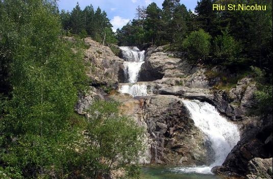
El Parc d'Aiguetortes és la zona amb més llacs dels Pirineus, per això l'aigua és la principal protagonista, tant per ser-hi la major concentració de llacs pirinencs com pels característics meandres d'alta muntanya, tan típics, que donen nom al Parc Nacional. Aquest últim fenomen es dóna principalment i assoleix la seva major bellesa en dos dels seus rius, el Sant Nicolau, entre els llacs Llong i Llebreta, i l'Aiguamòg.
Els llacs o estanys són un total de 272, entre grans i petits, gairebé tots d'origen glacial però molt variats per la seva situació, bé en els fons de les valls principals, com el Sant Maurici, el Llong o el Llebreta, o bé als alts fons de circs glacials com els de Mar, Rius, Monges, Mangades, Travessani, Negre, Contraix, Ratera, Redó, Gerber o Saboredo entre d'altres
Els primers solen trobar-se al voltant dels 2.000 m, mentre que els segons es troben a altituds entre 2200 i 2500 i estan clarament lligats a la pròpia formació del circ glacial.
Fauna del Parc
S'han comptabilitzat unes 200 espècies de vertebrats aproximadament, dels quals prop de tres quartes parts són aus com per exemple, la becada, el pinsà, el carboner palustre, la gralla de pitirroja, la gralla de bec groc, el picapinos, el voltor comú, el trencalòs, l'àguila reial, el picot negre, el mussol pirinenc, el gall fer, el cercavores ...
Pel que fa a les aus, és possible observar el merla d' aigua (Cinclus cinclus), que es capbussa dins l'aigua per tornar a sortir uns metres més endavant, al cap de uns segons, i esporàdicament apareixen al collverd (Anas platyrhynchos) i el bernat pescaire (Ardea cinerea).
També destaquen entre els mamífers els isards, els senglars, els cabirols, les llúdrigues, les marmotes, les mallerengues, els erminis, les martes, els teixons, les fagines, l'almesquera ...

En els estanys, a part del zooplàncton, viuen la truita comuna (Salmo trutta fario), la truita arc-iris (Oncorhynchus mykiss) i el piscardo (Phoxinus Phoxinus). Aquí abunden els amfibis, entre els quals la granota roja (Rana temporaria) i el gripau comú (Bufo bufo) són els més característics. També us podreu trobar el lució (Anguis fragilis) en llocs humits però assolellats, amb abundant vegetació herbàcia. Finalment, no hem oblidar el tritó pirinenc (Euproctus asper), estrella indiscutible dels torrents i llacs del Parc.
En els rius i rierols viu el almesquera (Galemys pyrenaicus), encara que és difícil veure'l a causa de seus hàbits nocturns, la seva raresa i restringida àrea de distribucció, i la llúdriga (Lutra lutra), mamífer de costums nocturns i crepusculars i de molt difícil observació.
Associats als cursos d'aigua trobareu a la cueta blanca (Motacilla alba) i la bugadera torrentera (Motacilla cinera), entre altres aus.
Flora del Parc
Aiguetortes té més de 1.400 espècies vegetals i, per raó de l'altitud, es distingeixen tres pisos de vegetació:
A les zones de menys altitud que ronden els 900 m. sobre el nivell del mar trobem boscos més densos que en les zones de més alçada. En aquestes zones de menor altitud (Fins a 1600m) ens trobem fonamentalment els roures, els pins silvestres, els bedolls, faigs, àlbers ... que formen un bosc mixt caducifoli molt peculiar i típic d'aquesta zona. Entre els 1600 i 2200 m. la varietat més significativa és el pi silvestre que comença apareixent entre el bosc mixt, encara que també apareix el pi negre, neret, boix o nabiu fins que cap als 2000m guanyen terreny el pi negre, les pastures i els matolls.
Els grans protagonistes
- Els encantats
Els Encantats són dues agulles –o dues puntes– de la muntanya del parc, al sud de l'estany de Sant Maurici. La punta oest (el Petit Encantat) té 2.734,3 metres d'alçada i el Gran Encantat 2.748,1 metres, i són separats per una gran enforcadura a 2.624 metres.
Petrogràficament, la vall de l'Escrita és formada del mateix granit normal de l'eix axial pirinenc; malgrat això, aquests dos pics són de pissarres plegades i roca calcària, d'una qualitat no gaire bona, però que ha donat lloc a aquestes espectaculars agulles.
Com moltes altres muntanyes, el seu nom neix entre antigues llegendes. En aquest cas la llegenda diu que aquestes dretes agulles eren de primer només dos caçadors que havien fugit de missa per ser els primers a batre l'isard i que van ésser maleïts i varen quedar petrificats per sempre.
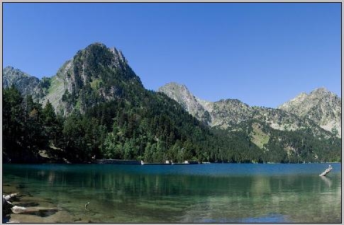
- El llac de Sant Maurici
L'estany de Sant Maurici és un antic llac engrandit amb una presa, dins del Parc
Està situat a 1.910 m d'altitud, al fons d'un circ d'origen glacial. Rep les aigües dels rius i torrents de Ratera, del Portarró i de Subenuix, mentre que el seu emissari, el riu Escrita, drena la vall d'Espot fins a la Noguera Pallaresa.
L'estany té uns 1.100 m de llarg per uns 200 d'ample, amb un volum d'aigua d'uns 2,6 Hm³, gràcies a una petita presa construïda per augmentar la seva capacitat.
I ara la descripció de les taques:
- Tasca 1: Feu-vos una fotografía AMB EL GPS a un lloc CLARAMENT reconegut del parc. En un panell informatiu també podria ser vàlid. Indiqueu on està presa i si voleu les coordenades. (Opcional.2 punts)
- Tasca 2: Farem un recòrregut on us proposem unes preguntes/exercicis que us ajudaràn a entendre la formació geològica del parc a través de milers d'anys. Si mireu el panell que trobareu aprox. a les coordenades inicials (parking) trobareu una llista de 10 recorreguts. Mireu el recorregut MES LLARG. Pots dir quan de temps s'inverteix a fer-lo sencer i fins on arriba? (2 Punts. Opcional ja que el parc te diferents entrades)
- Tasca 3: (Opcionals. 1 Punt per pregunta) Puja des del Parking al Llac de Sant Maurici.
- Pregunta 1: Mentre camineu aneu agafant roques i pedres dures. El parc gairebé està format en la seva totalitat per dos tipus, dels 6 que mostrem... saps quins?
-
-
- Pregunta 2 : Arribeu al llac de Sant Maurici i observeu ELS ENCANTATS. Si us fixeu en les valls que veieu, veureu que tenen una forma de U. Quin fet geològic de fa milers d'anys ha conferit aquesta caràcterística forma?
- Pregunta 3: La formació dels 'Encantats' és una formació granítica de gran bellesa, la seva forma ens explica una llegenda de dos caçadors que van ser petrificats per caçar un isard. Però els encantats no és la muntanya més alta del parc. Busqueu informació. Cerqueu muntanyes de característiques geològiques similars als Encantats dins el parc i digueu el nom de la més alta?
- Pregunta 4 : El nom del parc és degut a un altre fet asociat a l'esmentat en la pregunta 2. Sabries a què es degut aquest nom?
- Tasca 4: Aquesta tasca només puntua si a les altres tres, la puntuació iguala o supera 5 punts. És només una tasca-repte per aquells que vulguin aconseguir la màxima puntuació. (2 Punts)
Com es diu aquest sorprenent i poc conegut llac d'origen glaciar que trobem dins els límits del Parc d'Aiguetortes?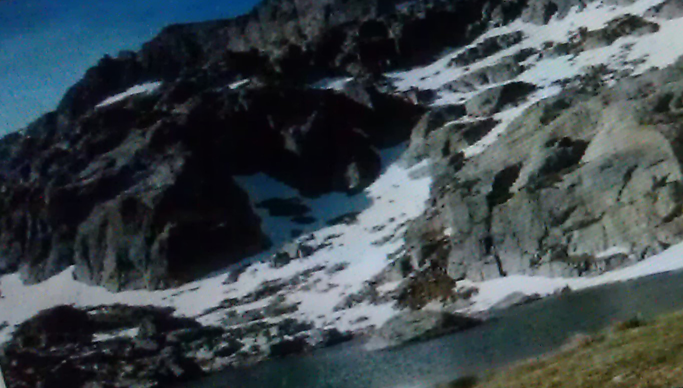
English version:
Welcome to this necessary EarthCache. Due to Groundspeak new guidelines I want to build this EarthCache as an exam. To log as FOUND you must get a minimum score of 5 points from 8 possible.
There are four OPTIONAL tasks to get points.
1) A photograph (Optional. Can make you get higher in the ranking of scores)
2) A ‘field’ question (2 points)
3) Four 'research' Questions (1 point each)
4) An extra task, applicable only to those who got 5 or more points in the three precious tasks. Otherwise this task will not be punctuable (2 points)
There will be a 3D certificate for FTF,STF and TTF and a podium amb the three geocachers with best scores.
Story of the Park
The National Park of Aigüestortes was created on October 21, 1955, with an extension initial 9,851 hectares. It was the fifth Spain's national park and the second of the Pyrenees, after the Ordesa National Park.
On May 29, 1976 it was announced an expansion of the park, including
the forest in the Mata Montardo mountain.
The Aigüestortes Park is located in the Pyrenees and is divided between the regions of Pallars Sobirà (Municipal term of Espot), Pallars Jussà, Vall d'Aran and Alta Ribagorça (Municipal term of Vall de Boí).
Park Geology
The relief of the park was formed about two hundred million years emerging from bottom of the sea that covered this land. For several
glacial periods, ice masses occupied all these valleys, eroding the landscape and giving it looks today. This landscape characterized by glacial cirques and valleys U shaped, some of them hanging and other staggered and more than two hundred lakes. Some of these lakes have undergone a process of sedimentation, which has caused the development plans and kept wet meadows, where river waters are divided into numerous meanders
called "aigüestortes." This is one of the best representations of the Quaternary glacial erosion.
Aigüestortes Park is the area with more lakes Pyrenees, so that water is the main protagonist not only to be the largest concentration of Pyrenean lakes
but also for the characteristic meandering in high mountains, so typical, that gives the name to the National Park. This beautiful phenomenon can be seen in two of its rivers, the San Nicolás, including Llebreta Llong and lakes, and Aiguamòg.
Lakes or ponds are 272, between large and small, almost all of glacial origin but varied by their situation, either in the valley bottoms main as the Sant Maurici, the Llong or Llebreta, or to the high glacial cirques funds such as Ocean, Rivers, Nuns, Mangades, Travessani, Black, Contraix, Ratera, Redó, Gerber, Saboredo, etc.
The former tend to be around 2,000 m, while the latter are found at altitudes between 2200 and 2500 and are clearly linked to the formation itself cirque.
Wildlife Park
Have been recorded about 200 species of vertebrates approximately, of which about three quarters parts are birds such as woodcock, finch, saithe palustre, the Chough pitirroja, the Chough Yellow the woodpecker, the common vulture, the osprey, the eagle real, the black woodpecker, the boreal owl, grouse,
the Alpine Accentor ...
As for birds, it is possible to observe the blackbird water (Cinclus Cinclus), which dives into the water back out a few meters ahead, after a few seconds, and sporadically in the real (Anas platyrhynchos) and Grey Heron (Ardea cinerea).
Also noteworthy among mammals the chamois, the wild boar, roe deer, otters, marmots, the charcoal, ermine, martens, badgers, martens, the outrage ...
In ponds, a part of the zooplankton, live trout (Salmo trutta fario), rainbow trout
(Oncorhynchus mykiss) and fathead minnow (Phoxinus Phoxinus). Amphibians abound here, including the frog (Rana temporaria) and common toad (Bufo bufo) are most characteristic. Also you can find the solution
(Anguis fragilis) in damp but sunny with abundant herbaceous vegetation. Finally, we forget Pyrenean newt (Euproctus asper), undisputed star the streams and lakes in the park.
In rivers and streams live the muskrat (Galemys pyrenaicus), although it is difficult to see nocturnal habits, its rarity and restricted range distribution, and the otter (Lutra lutra), mammal nocturnal and crepuscular and very difficult observation.
Associated with watercourses in the wagtail (Motacilla alba) and wagtail (Motacilla cinera), among other birds.
Flora Park
Aigüestortes has more than 1,400 plant species, and reason altitude, there are three layers of vegetation:
In areas of lower altitude of around 900 m. on sea level, forests are denser than in the highest elevations. In these lower altitudes (Up to 1600m), we find essentially oaks, Scots pine, birch, beech, poplar ... that mixed deciduous forest are very peculiar and typical in this area. Between 1600 and 2200 m. the widest Scots pine is significant starting appearing between the mixed forest, but also appears black pine, rhododendron, boxwood or blueberry to that towards 2000m win ground black pine, grasses and shrubs.
The main protagonists
The Enchanted (Els Encantats)
The charms are two needles, or two points-of Highland Park, south of Lake Sant Maurici. The west side (the Little Enchanted) is 2734.3 meters
high and the great charm 2748.1 meters, and are separated by a great Enforcadura to 2,624 meters. Petrographically, the valley is shaped Written
same granite Pyrenean axial normal, although However, these two peaks are folded and rock slate limestone, not very good quality, but has since
spectacular rise to these needles.
Like many other mountains, its name comes from ancient legends. In this case, the legend says These rights of first needles were only two hunters
who had fled from Mass to be the first to beat chamois and were cursed and were petrified forever.
Sant Maurici Lake
The pond is an old Sant Maurici lake enlarged with making within the Park
It is located 1,910 m above sea level at the back of a circus glacial. Receives water from rivers and torrents Buzzard, the Portarró and Subenuix, while its
emissary Written River, drains the valley to Espot the Noguera Pallaresa.
The lake is about 1,100 m long and about 200 wide, a water volume of about 2.6 ³ Hm, thanks to a small dam built to increase capacity.
And now the description of the goals:
Task 1: Take a picture with your GPS in one place of easy recognition in the park. An information panel could also be valid. (No punctuable . It is optional and therefore it will just be used in case of equal puntuations)
Task 2: We propose a geologic tour with some questions and exercices that will show you the geological formation on this park throughout thousands of years. If you look at the information panel at the initial coordinates(parking) you will find a list of 10 routes. Look for the longest one and follow the path.We will stop before arriving at the end we we find the SANT MAURICI lake, but could you tell how long is this whole route and what is the destination?. (2 Points)
Task 3: (1 Point per question)
Question 1: The route we chose, will pass by the Sant Maurici lake. Meanwhile take som rocks and stones. The park is formed basically for two diffrent types (see picture) Do you know which two? ( quartz, granite, mica, slate, graphite and talc )
Question 2 : Now you are in the Sant Maurici. From Here you can see the magnificient THE ENCHANTED. But look at the valley. In the park the valleys are shaped in a U form. Do you know what geological action from thousands of years gave this shaped the valleys like this?
Question 3: The Enchanted is a wonderful granitical formation. Its shape tells a legend of two hunters who were petrified for hunting a deer. But The Enchanted it is not the highest mountain within the parc. Look at the info panel, search for mountains of similar geological characteristics of The Enchanted and tell us the name of the highest
Question 4 : Finally, The name of the park is due to the geological action we dicuss in question 2. Do you now why? "aiguestortes" = "Tortuos waters"
Task 4: This task only valid if the you get 5 points o more points in the previous tasks. It's just a challenge task for those who want to achieve the maximum
score. (2 Points)
What is the name of this amazing and almost unknown glaciar-formed lake we found within the Park ? (See picture at the spanish version)