Welcome to Platts Lookout, located at a easy 1011 feet this
viewpoint looked out over the Stossel Valley and most likely was
used to check for fires caused by local logging operations as this
area was actively logged during the time this lookout point was in
use.
According to Ray Kresek's Fire Lookouts of the Northwest, the
Washington Division of Forestry (the DNR since 1955) "built" the
camp that used to be here sometime in the 1930s and also mentions
that the camp is now abandoned. According to the information I have
been able to find this location was in use by the local Fire Warden
(Platt) as a viewpoint in 1936 when the nearby benchmark went
in.
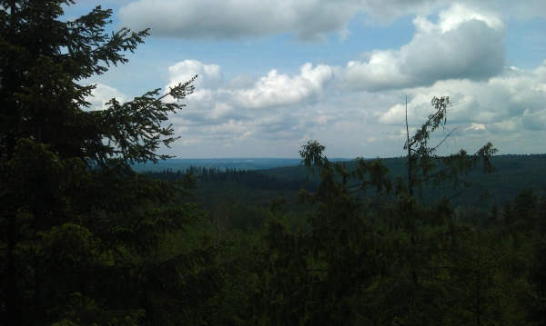
This is the view to the west
Text of the nearby benchmark
USGS Benchmark SX1527
DESCRIBED BY COAST AND GEODETIC SURVEY 1936 (HJO) STATION IS 1/4
MILE S OF THE SNOHOMISH-KING COUNTY LINE ON A HEADLAND ON THE S
SIDE OF CHERRY CREEK JUST W OF THE HEADWATERS OF STOSSEL CREEK. IT
IS USED BY FIRE WARDEN PLATT AS A LOOKOUT POINT. IT IS IN THE NW
1/4 SEC. 1, T. 26, R. 7. PROCEED FROM STILLWATER (3 MILES N OF
CARNATION) NORTHEASTWARD UP HARRIS CREEK 6.4 MILES, TAKE LEFT FORK
UP STOSSEL CREEK (N) 2.1 MILES TO A SMALL LAKE ON LEFT. THIS IS IN
THE N CENTRAL PART OF SECTION 12. STATION IS ON THE HEADLAND OR
KNOB 1-1/4 MILES N AND 1/4 MILE W FROM THIS LAKE. PROCEED N 0.6
MILE. FIND SMALL TRAIL ON LEFT AND FOLLOW IT TO THE KNOB. STATION
IS AT THE TOP.
There are still great views to the west and I was able to see
Seattle from here. Additional peekaboo views are available to the
north as well. No evidence of human activity from the lookout
exists that I could find, but you will most likely be able to find
an occasional beer can or shotgun shell so please rehide it
well.