 |
Welcome to Amsterdam!
City of charming canals, lovely parks and cheap entertainment. And of course: lots of geocaches! Although we are not as endowed as many other European or American cities, we do have our share of interesting caches for visitors from abroad. But beware: the Dutch love their micros, multis and mysteries!
|
Foreign visitor and wondering which caches to do? Check out: Amsterdam for (foreign) visitors. The ultimate English-friendly Amsterdam cache list!
Voor de Hollanders: deze achtergrondinfo is primair voor touristen. Niks zo irritant als op vakantie een cache willen doen en alle beschrijvingen zijn in het zweeds/portugees/etc. Jeweettoch! ;) De meeste bronlinks zijn wel Nederlands, en voor landgenoten die gewoon 's avonds thuis achter de pc kunnen gaan zitten staat daar nog veel meer en uitgebreidere informatie.
|

|
| Dikes and Polders |
Polders
A polder is an area of land that is lower than the surrounding water, and of which the water level can be artificially controlled. The Netherlands has about 3000, and almost the entire western part of the Netherlands consists of polders. The land can either have been directly reclaimed, or it was pumped dry after the ground had sinked due to the excavation and subsequent parching of the peaty soil ('veen'). Without actively pumping these areas dry they would turn into lakes. The Beemster and the Haarlemmermeer (including Schiphol airport) used to be such lakes (they were pumped dry by mills later). Schiphol ('ship hole') is even named after a naval battle!
|
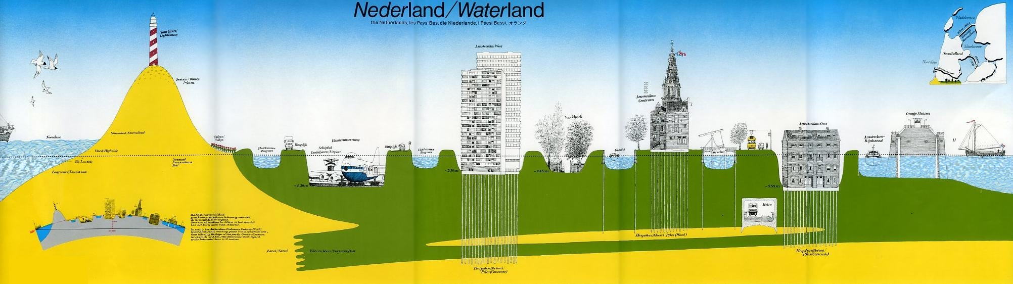 |
Left to right: Northsea (NAP 0), Dunes with lighthouse (NAP 7-20mtr), Tulips, Haarlemmer ringvaart & ringdike (with car), Schiphol Airport in the Haarlemmermeer polder (NAP -4.5mtr), Haarlemmer ringvaart & ringdike again, an apartment building in Amsterdam West on concrete piles (NAP -2.10mtr), Vondelpark (NAP -2.45mtr), the canalbelt on wooden piles (NAP 0), the Metro (various depths), Amsterdam East (Watergraafsmeer) on concrete piles (NAP -5.50mtr), the Amsterdam-Rijnchannel, the Oranje sealocks and the IJ (the body of water directly North of Amsterdam).
|
Dikes
Land reclamation started in the 11th century, when coastal areas were diked in. It wasn't until the beginning of the sixteenth century that larger bodies of water could be reclaimed. Starting with small lakes, a century later they were reclaiming lakes as big as 120km2!
Although extremely laborious, the process is relatively simple. First a dike and canal (ringdijk and ringvaart) are placed around the lake. Then the lake is pumped dry using (many!) watermills on the dike. The resulting marsh-like land is then cleverly cultivated to remove the salt from the soil, and to make it solid (which takes years). The water level is controlled through waterways throughout the polder, and pumping from these needs to be continued indefinitely.
|
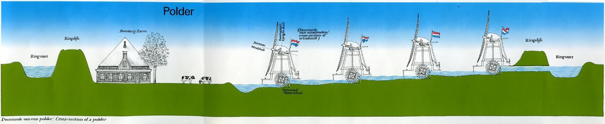 |
Left to right: ringcanal (ringvaart), ringdijk, farm, cows, waterpumping windmills, ringdijk with a drainage canal and ringvaart again.
|
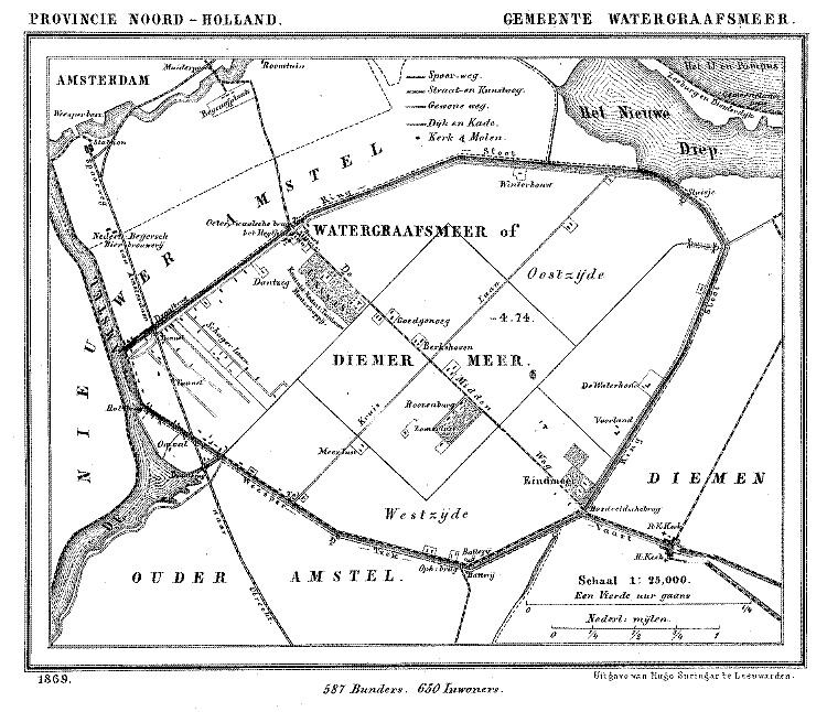
Watergraafsmeer
You are now standing on the ringdike around the Watergraafsmeerpolder. Reclaimed in 1629, it used to be the Diemermeer (lake Diemer). Contrary to what many Dutch think it's not named after a local 'Watergraaf' ('watercount or -earl', a title that doesn't even exist). Instead the name derives from the original name 'Watergraftsmeer', where 'graft' simply means 'canal'.
Only 22 years after reclamation it flooded again in 1651 due to storm, killing 5. This massive flood even hit Amsterdam, where water flowed down the warmoesstraat. It took about a year to pump the polder dry again.
But another 20 years later, when the French army approached in 1672, the city ordered to break the dikes in order to inundate the Dutch Water Line for the first time. It worked, the French never got Amsterdam, but the Watergraafsmeer ended up flooded, pillaged and devastated.
A mere 15 years later, in 1787, the approach of the Prussian army raised the same idea again. Only this time the resident of Watergraafsmeer refused.
And finally, in fear of a possible approach by the allied forces in 1945, the ringdike had been rigged with dynamite by the German army to do the same. Luckily the war ended before they could actually blow the dikes.
(Ultimately, a polder's biggest enemy isn't the French or the Germans, it's the muskrat. They dig right through the dikes, invisibly undermining it's structural integrity. It's actively hunted to extinction in the Netherlands).
|
 |
 |
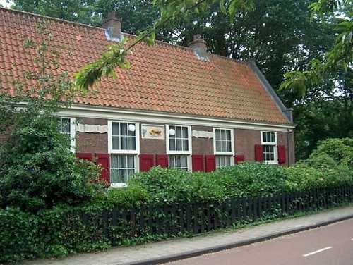
| The old farm "De Vergulden Eenhoorn" |
The Watergraafsmeer in 1869, with the two main streets Middenweg and Kruislaan crossing right in the centre. |
Habitation
Although the Watergraafsmeer was predominantly farmland until the 1970s, many wealthy families from Amsterdam built estates here during the 17th and 18th century. Of about 40 in total, only Frankeldael remains (open daily 10-17hr, exhibitions and tours). Meanwhile, the farm "De Vergulden Eenhoorn" was the only house on the ringdike between around 1700 and 1972. It's still there, about 130mtr from the cache southwest along the ringdike.
Finally, Watergraafsmeer is a historic site. AFC Ajax (***) had its stadium 'De Meer' here from 1934 until 1996, and their legendary Nr.14 Johan Cruijff was born practically next door, in Betondorp (southern part of Watergraafsmeer).
|
| source: Wi ki pedia |
The Cache
The cache used to be located right on the ringdijk, against the bridge. However, since it was quickly ripped it moved 27m to the south (next to the stairs). It also shrank from regular to small. There, after two years, local kids found it. So now, it moved another 100 meters Southwest. On the upside: it's back up on the dike, so you can experience the full lowlands-feel again!
The location is about 650mtr from Amstel Station (SW) and 800mtr from Tram 9 on the Linnaeusstraat/Middenweg (NE). Frankendael is 500mtr SE, the Oosterpark is 700mtr N and the Weesperzijde (very lovely 1km stroll back to the centre along the Amstel river!) is to the West.
FTF gets a 'gold' dollar.
Beware: Urban Caching is less about the search, but all about the STEALTH. They are often easy to find, but hard to log unnoticed!
PLEASE TAKE AS MUCH TIME STEALTHING AS YOU WOULD NORMALLY FOR SEARCHING!
|