What! Cliffs in Essex? EarthCache
-
Difficulty:
-

-
Terrain:
-

Size:  (other)
Please note Use of geocaching.com services is subject to the terms and conditions
in our disclaimer.
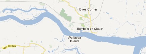
This is a 1.8 mile walk from Burnham-on-Crouch marina to Creeksea Cliffs passing some lovely views of the river crouch and some geocaches;
River Geology
From the top of the cliffs you can see the river crouch gently 'Meandering' in both directions from west to east and out to the north sea.
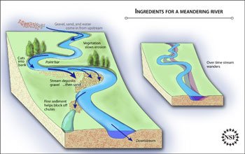
Meander formation is a result of natural factors and processes. The waveform configuration of a stream or river is constantly changing. Fluid flows around a bend in a vortex. Once a channel begins to follow a sinusoidal path, the amplitude and concavity of the loops increase dramatically due to the effect of helical flow sweeping dense eroded material towards the inside of the bend, and leaving the outside of the bend unprotected and therefore vulnerable to accelerated erosion, forming a positive feedback loop.
Erosion Mechanics
Most meanders occur in the region of a river channel with shallow gradients, a well-developed floodplain, and cohesive floodplain material. Deposition of sediment occurs on the inner edge, because the secondary flow of the river sweeps and rolls sand, rocks and other submerged objects across the bed of the river towards the inside radius of the river bend, creating a slip-off slope called a point bar. Erosion is greater on the outside of the bend where the soil is not protected by deposits of sand and rocks. The current on the outside bend is more effective in eroding the unprotected soil, and the inside bend receives steadily increasing deposits of sand and rocks, and the meander tends to grow in the direction of the outside bend, forming a small cliff called a cut bank. This can be seen in areas where willows grow on the banks of rivers; on the inside of meanders, willows are often far from the bank, whilst on the outside of the bend, the roots of the willows are often exposed and undercut, eventually leading the trees to fall into the river. This demonstrates the river's movement. Slumping usually occurs on the concave sides of the banks resulting in mass movements such as slides.
Local Area History
For many millions of years the Dengie 100 was under the sea.
During the Eocene epoch about 55 million years ago Essex was in a shallow tropical sea similar to modern day Malaysia. During this period, over about 3 million years, rivers flowing from the mainland dropped silt which formed the modern London Clay bet that is a predominant feature of our soil.
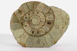
Into this new clay soil at the bottom of the sea dropped a variety of sea life that became fossilised.
The clay is rich in minerals with selenite , a variety of gypsum, that forms clear crystals.
In more recent times the Thames/Medway River crossed the Dengie 100 to meet the Sea north of Bradwell on Sea. During this period the river cut into the london clay leaving deposits of sand and gravel . During the Ice Age the Thames became blocked in Hertfordshire by a glacier and a large lake was formed. This lake eventually forced a new path which led to the Thames and Medway adopting its current route.
The ice age brought many new animals with fossils of mammoths, hyena, hippopotamus, wolves and Reindeers all being found in the area. In 1983 a superb Mammoth tusk was found on the shore of the River crouch at Burnham on crouch by local historian Les Holden. The tusk can be viewed in Chelmsford Museum.
Creeksea Cliffs
A cliff on the outer bend of the River crouch is being eroded which exposes fossils which can be found on the shingle beach below the cliffs. Sharks teeth and other fossils from this site can be viewed in nearby Burnham on Crouch Museum.
To claim this Cache you must email your answers to the questions below to gc34ya2@hutchyweb.co.uk:
- How heigh are the cliffs above sea level?
- Estimate the distance between the cliff and the meander to your right?
- Estimate the distance between the meander to your right and the meander to your left?
- The island to your right (up river) was created by which meandering process?
- Estimate the width of the river Crouch at this point?
- As you walk up the cliff you may notice ruts in the soil what are these?
- Take a photo of yourself with the Crouch Valley in the background (Optional).
Upload the photos with your log.
Additional Hints
(No hints available.)