EL 'BUFADOR' DE PEÑISCOLA
El Bufador de Peñiscola es un Monumento Natural, está situado en el peñón que sustenta el casco antiguo de Peñiscola,y presenta una morfología kárstica, que junto al fenómeno periódico de los golpes de mar, son los responsables de la principal singularidad del lugar.
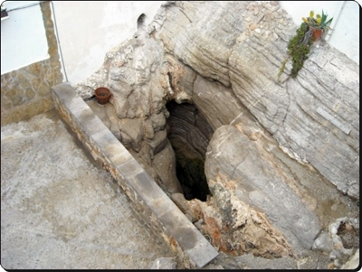
El bufón que nos ocupa es una grieta o chimenea abierta en la costa y conectada con una sima marina por la que el agua del mar penetra a presión, formando un surtidore de agua pulverizada visibles desde el exterior y que pueden alcanzar más de 10 metros de altura.
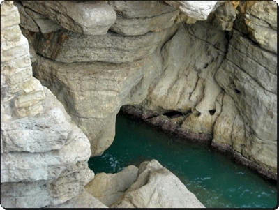
La formación de este 'Bufador' se basa en la disgregación de la roca caliza por efecto de la erosión del agua de lluvia. La lluvia penetra por pequeñas fracturas o zonas de mayor debilidad hasta el nivel del mar. La acción erosiva del mar favorece el agrandamiento de las pequeñas cavidades originales, provocando con el paso del tiempo que se forme una cueva en comunicación con el conducto vertical. Con la llegada de las olas, el aire o el agua que existe en la cueva se comprime y sale a gran presión al exterior.
el bufador enfadado...
Si la mar esta en calma el respiradero de la cavidad subterránea se limita a expulsar el aire, comprimido en las galerías por los golpes del oleaje. Sin embargo en los días de fuerte marejada el bufador se transforma en un espectáculo que produce admiración y temor. Entonces el aire y el agua, apretados en esas angosturas subterráneas, escapan juntos por los resquicios de la adelgazada bóveda. La tierra se abre escupiendo al cielo trozos de mar con ensordecedor ruido.
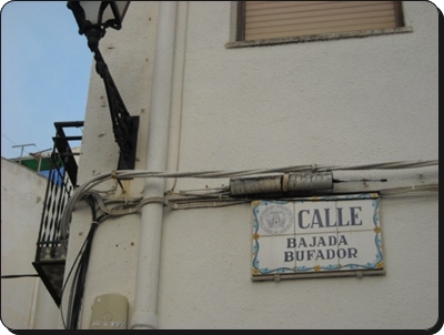
En las coordenadas: N40 21.450 E0 24.325 podréis aparcar para ir a visitar el Bufador. Accediendo al recinto amurallado de Peñiscola por el denominado Portal de Sant Pere situado muy cerca en N40 21.443 E0 24.376.
PARA 'LOGUEAR' EL EARTHCACHE:
Debeis responderme a estas preguntas mandandomelas por email a traves de mi perfil. Podeis 'loguear' el cache directamente; Yo veré las respuestas y os contestaré con un OK, o no.
a) ¿De que tipo es el terreno que ha dado origen al Bufador?
b) Enfrente del Bufador, hay unas escaleras que conducen al Fortin del Bonet. Es una plataforma de vigía enclavada en la muralla. Desde ella se puede ver la entrada del mar a la sima. ¿Hacia que direccion esta orientada? Y,por tanto. ¿De que direccion vendrá el temporal que más hará resoplar a 'nuestro amigo'?
c) ¿Que altura aproximada calculas que tiene la grieta? -De dos a tres metros. -De cinco a diez metros. -O más de veinte.
d) En el mismo mirador hay una garita de guardia... ¿Cuantos barrotes de hierro tiene la puerta?
e) Asimismo,deberéis mandar una foto vuestra o de vuestro GPS con el Bufador de fondo. Espero que seais originales.
Los Logs incorrectos o incompletos serán eliminados. Asi como los que puedan contener algunas de las respuestas.
CONSEJO: La mejor epoca del año para disfrutar de El Bufador es en otoño e invierno, durante un temporal y con marea alta.
Podeis ver cuando esta la marea alta aqui:
¡¡¡ATENCIÓN!!! En dias de temporal El Bufador puede ser peligroso y hay que
observarlo desde cierta distancia para evitar accidentes...
¡POR FAVOR SER PRUDENTES!
Espero que os guste y un saludo...
English:
The Bufador of Peniscola is a Natural Monument is located on the rock behind the old town of Peniscola, and has a karst morphology, which together with the periodic phenomenon of heavy seas, are the main responsible for the uniqueness of the place.
The clown at hand is a crack or open fire on the coast and marine gulf connected with the sea water that penetrates under pressure, forming a water spray surtidore visible from the outside and can reach more than 10 meters height.
The formation of this 'Bufador' is based on the disintegration of the limestone by erosion by rainwater. Rain seeps through small cracks or areas of weakness to the sea level. The erosive action of sea favors the enlargement of small cavities originals, causing with the passage of time to form a cave in communication with the vertical duct. With the arrival of the waves, air or water in the cave there is compressed at high pressure goes outside.
the angry bufador
If the sea is calm vent the underground cavity is limited to expel the air compressed in the galleries by the blows of the waves. But in the days of rough seas the Bufador becomes a spectacle that produces admiration and awe. Then the air and water tight in these narrows underground escape together through the cracks of the thinned vault. The earth opens to the sky spitting bits of sea with deafening noise.
In the coordinates: N40 21,450 24,325 E0 you can park to visit the Bufador. Accessing Peñiscola walled by the so-called Portal de Sant Pere is located very close to N40 21,443 24,376 E0.
FOR 'Log In' THE EarthCache:
You ought to answer these questions sending by email through my profile. You can 'Log In' the cache directly, I will see the answers and I will reply with an OK or not.
a) In what type is the land that has given rise to Bufador?
b) In front of Bufador, there are stairs leading to the Bonet Fortin. It is a lookout platform located in the wall. From here you can see the sea entrance to the cave. Towards that direction is oriented? And, therefore. In what direction will the storm that will blow over to 'our friend'?
c) What calculate approximate height that has the crack? -Two to three meters. -Five to ten meters. -O more than twenty.
d) In the same viewpoint is a guard gated ... How many bars of iron is the door?
e) In addition, you will have to send a photo of you or your GPS with background Bufador. I hope you are original.
The Logs incorrect or incomplete will be deleted. Just as those that might contain some answers.
TIP: The best time of year to enjoy the Bufador is in autumn and winter during a storm and high tide.
You can see when high tide is here:
ATTENTION! In days of temporary Bufador can be dangerous and must watch from a distance to prevent accidents ...
PLEASE BE CAREFUL!
I hope you enjoy it and greetings ...