
 During one of the more recent glacial
periods, about 20,000 years ago, the ocean receded to a shoreline
out near the Farallon Islands about 27 miles to the west. At that
time, the San Francisco Bay was a broad open valley teeming with
the megafauna of the Pleistocene.
During one of the more recent glacial
periods, about 20,000 years ago, the ocean receded to a shoreline
out near the Farallon Islands about 27 miles to the west. At that
time, the San Francisco Bay was a broad open valley teeming with
the megafauna of the Pleistocene.
Through this valley, the river we now call the Sacramento River
flowed out through the Golden Gate Headlands and across the coastal
plain to empty into the ocean somewhere near the Farallon Islands.
The Ancient Sacramento River likely was the drainage for 40% of
California and thus had a high flow. 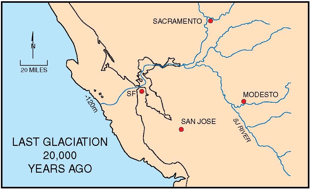 Estimates based on how deep the bedrock is below
the bay suggest that the river bed dropped over 200 feet between
Angel Island and the Golden Gate (about 2 miles) creating a series
of cascades. The sediments that the Sacramento River transported
out on the coastal plain were blown back landward forming huge dune
fields (See The
Sands of Time ). One of those dune fields has now been
submerged and is called the Potato Patch Shoals.
Estimates based on how deep the bedrock is below
the bay suggest that the river bed dropped over 200 feet between
Angel Island and the Golden Gate (about 2 miles) creating a series
of cascades. The sediments that the Sacramento River transported
out on the coastal plain were blown back landward forming huge dune
fields (See The
Sands of Time ). One of those dune fields has now been
submerged and is called the Potato Patch Shoals.
 By about 18,000 years ago, temperatures had been
increasing, melting the continental ice sheets and ocean levels
were rising again. The melting ice from the glaciers in the Sierra
Nevada Mountains would have added to the flow of the Sacramento
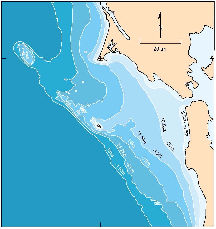
River helping erode the channel through the Golden Gate. By about
8,000 years ago the rising sea levels drowned the river channel,
turning the gap into the Golden Gate Strait and began filling the
San Francisco Bay. Today the Golden Gate Strait remains open due to
the swift tidal currents that flow through it. The figure below
shows an interpretation of where the coastline was at various times
between 18,000 years ago (18ka on the map) and present day.
By about 18,000 years ago, temperatures had been
increasing, melting the continental ice sheets and ocean levels
were rising again. The melting ice from the glaciers in the Sierra
Nevada Mountains would have added to the flow of the Sacramento
River helping erode the channel through the Golden Gate. By about
8,000 years ago the rising sea levels drowned the river channel,
turning the gap into the Golden Gate Strait and began filling the
San Francisco Bay. Today the Golden Gate Strait remains open due to
the swift tidal currents that flow through it. The figure below
shows an interpretation of where the coastline was at various times
between 18,000 years ago (18ka on the map) and present day.
The question that has not really been resolved is why did the
river cut through the headlands at this spot? Highly resistant
rocks are present on both sides of the headlands and ranges of
hills extend north and south for many miles. There are two
theories: one theory is that the ancient Sacramento River course
predated the mountains and eroded through the mountains as they
grew. The headlands are actually relatively young and the erosive
power of the river with the added flow from melting glaciers could
have maintained its course through the growing mountains. The other
theory is that there is an unidentified fault that runs through the
strait. The bedding planes of the rocks on either side of the
strait are different suggesting a fault.Neither theory has enough
evidence to be fully accepted because the evidence lies under the
water.
Logging questions:
- The text "GC3BKWC Golden Gate Strait – A Drowned River
Valley" on the first line
- The number of people in your group.
- What is the velocity of the tidal flow that goes through the
straight and what river is it compared to?
- How much lower was the sea level during the last Ice Age
according to the information sign?
- Based on the image on the information sign how much of the bay
would be above sea level?
The above information was compiled from the
following sources:
- Keller, Barry R., 2009, Literature review of
unconsolidated sediment in San Francisco Bay and nearby Pacific
Ocean coast, San Francisco Estuary and Watershed Science,
7(1)
- Ted Konigsmark; Trip 5.FORT FUNSTON Recent and
Ancient Beaches and Dunes,
http://www.geologictrips.com/sf/indexsf.htm
- Webber, Gerald E. and Alan O Allwardt, The
Geology from Santa Cruz to Point Año Nuevo— The San Gregorio
Fault Zone and Pleistocene Marine Terraces in Geology and Natural
History of the San Francisco Bay Area: A 2001 NAGT Field-Trip
Guidebook