Burning Pipes (Bonus) Mystery Cache
Team Tuxawuxa: Archiving due to bogus logs by tomhoehm and cyclegreen on some of my local caches.
-
Difficulty:
-

-
Terrain:
-

Size:  (small)
Please note Use of geocaching.com services is subject to the terms and conditions
in our disclaimer.
This is the bonus cache for Quemazon Treasure Hunt (GC3BTHH).
Coordinates are for near the last stage of Quemazon Treasure Hunt. The Bonus' cache can only be found by copying down the numbers at the top of the log in cache locations 2, 3 and 4.
Cache 2: A=? B=? Cache 3: C=? D=? Cache 4: E=? F=?
N 35 53.ABC W 106 21.DEF
This hike is approximately a 6 mile round trip hike that will take you near the intersection of Pipeline Road and Quemazon Trail. The last few standing Ponderosa Pines make for a great resting spot before heading on. Continue on to Guaje Ridge trail if you would like(10mi round) for great views of the ski hill.Connecting from Guaje Ridge Trail to Mitchell Trail is possible, but not recommended in the winter months.
Here's a coord checker if you use a mobile device, just to ease the thought of missing just one number that is over a mile away!

Congrats to TeamDonutDog on the FTF!
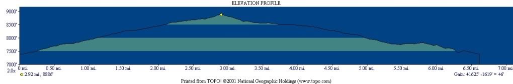
Here is an elevation profile for the hike if you start at Quemazon off 48th to Pipeline in the Quemazon housing community. The highest elevation is where the cache lies.
There has always been confusion on what trail is truly Quemazon trail. Quemazon begins at the small service road off of Trinity Drive at the intersection of 48th. The main trail bears right as Quem. Nature Trail 287 bears left. in 1.5 mi. the two trails meet again, .1 mi ahead Cave of the Winds trail bears left marked by a cairn. 3 mi. in the wagon trail meets Pipeline Road (An often used jeep trail now locked which stems from top of Quem. housing development.) . After the merge the trail is much easier to follow (Los Conchas fire did a number on the upper portion near the ski hill, the trail is highly exposed with soil slides on the canyon edge.) until it connects with Guaje Canyon Trail (Canada Bonita). Quemazon Canyon runs between both the main branch and Pipeline hence the confusion.
LA County Lonely Cache Stats
Additional Hints
(Decrypt)
Va n penpx va gur obhyqref arne n fznyy gjvfgrq, oheag fghzc. Abg sne sebz gur genvy whapgvba naq abg sne sebz gur pnalba rvgure