[ENGLISH]
Introduction and local Geology
The higher peaks of the Arrábida’s mountain chain, which can be considered roughly bounded by the 250 meter contour, correspond to outcrops of limestone of Jurassic age (approximately 150 to 200 million years old) and are, from west to east: the Píncaro, Arrábida (s.s.) and São Luis. The great southern slope, whereby Arrábida dives in the waters of the bay of Setúbal, owes its formation to a major tectonic feature with the same orientation. The southern coastal strand is the great escarpment limiting the chain and provides the uniqueness of this mountain chain.
In the location given by the published coordinates you’ll be close to the highest coastal point of the Portuguese mainland, termed the “Píncaro”. From here, looking SW, you can see the huge cliff that dives into the waters of the Atlantic Ocean. Turning to NW you can see the western part of the Arrábida mountain chain, completely flattened by a quite perfect applanation, probably due to marine abrasion/erosion. The platform was later uplifted forming what is today known as "Plataforma do Cabo" or Cape Platform. Looking NE you may observe the “Formosinho” anticline (Formosinho at 501m a.m.s.l. is the highest point of the Arrábida mountain chain) and further away, the anticline making up the “Serra de São Luis”.
The Cache
Go to ground zero and
(1) using or GPSr measure the altitude above sea level of GZ or estimate it using basic trigonometry;
(2) what is the colour of the rocks close to the fault plane (cliff)?
(3) those rocks are flat or do they have visible signs of erosion?
E-mail the answer through my profile and log the cache if you think you've the correct answers. A photo of you in the place with your GPSr would be appreciated.
What lesson can be learned from this EC?
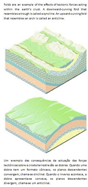
The effects of tectonic forces acting within the earth’s crust
Most information on this listing was compiled from “Notícia explicativa da folha 38-B Setúbal da Carta Geológica de Portugal” published by the Departamento de Geologia do Instituto Geológico e Mineiro.
I want to thank Daniel de Oliveira for his essential advice in preparing this EarthCache.
[PORTUGUÊS]
Introdução e Geologia local
Os elementos mais elevados da cadeia da Arrábida, que se podem considerar aproximadamente circunscritos pela curva de nível de 250m, correspondem a afloramentos de calcários do jurássico (há 150 a 200 milhões anos aproximadamente) e são, de Oeste para Leste: o Píncaro, a Serra da Arrábida (propriamente dita) e a Serra de São Luís. A grande escarpa meridional, pela qual a Cadeia da Arrábida mergulha nas águas da baía de Setúbal, deriva com certeza de um importante acidente tectónico com a mesma orientação. A vertente costeira meridional é a grande escarpa litoral que limita a cadeia a Sul e que confere o essencial da sua inconfundível originalidade a esta cadeia montanhosa.
Na localização dada pelas coordenadas publicadas encontra-se perto do ponto costeiro mais alto de Portugal continental, o Píncaro. Daí, olhando para SW, pode observar-se a enorme escarpa que mergulha nas águas do Atlântico. Olhando depois para NW podes observar a parte Ocidental da cadeia da Arrábida, completamente arrasada por uma aplanação bastante perfeita, devido à abrasão marinha e que foi posteriormente soerguida, dando origem ao que hoje se conhece por “Plataforma do Cabo”. A NE podes observar o anticlinal do Formosinho, o ponto mais alto da Serra da Arrábida (501m) e mais longe o Anticlinal da Serra de São Luís.
A Cache
Dirige-te ao GZ e
(1) usando o GPSr mede a altitude a que te encontras;
(2) as rochas junto ao plano de falha (arriba) são de que côr?
(3) essas rochas são planas ou evidenciam sinais de erosão?
Envia as tuas repostas através do meu perfil e podes fazer o teu log se achas que as respostas estão certas. Uma foto tua no local com o teu GPSr seria bem-vinda.
O que se pode aprender com esta EC?
Os efeitos das forças tectónicas na formação da crosta terrestre
A maioria da informação nesta página foi compilada a partir da “Notícia explicativa da folha 38-B Setúbal da Carta Geológica de Portugal” publicada pelo Departamento de Geologia do Instituto Geológico e Mineiro.
Quero agradecer ao Daniel de Oliveira pelos seus conselhos indispensáveis na preparação desta Earthcache.
para mais detalhes sobre o percurso ver >>> risco 01 start <<< for detailed info about the route see