A
Earthcache
No texto abaixo, assim como no local das coordenadas, poderá obter as informações necessárias para responder às seguintes questões. Estas devem ser respondidas para o meu
email de modo a poder fazer o registo como encontrada. Se tal não for feito o registo será apagado sem qualquer tipo de aviso. Não necessita de esperar pela minha autorização para efectuar o registo. Se existir algum problema será contactado(a) de modo a resolvê-lo.
- Em que século o cordão dunar, no seu avanço para sul, atingiu a região onde se situa a ermida de Nossa Senhora das Areias?
- Se até chegar aqui fez o trajecto a pé, provavelmente já se deparou e bem com os sedimentos depositados, quer pelos rios quer pelo mar, na formação do cordão dunar. Qual o nome que vulgarmente chamamos a esse tipo de sedimentos?
- No local onde se encontra provavelmente verá restos de organismos marítimos, marca da presença do mar nesse ponto, em outros tempos. Que restos de organismos marítimos consegue ver misturados com os sedimentos?
- Encontra-se junto a um poste. Qual o número pintado a azul que se encontra nesse poste?

The Earthcache
In the text below, as well in the place pointed by the coordinates, one can find the necessary information to answer the following questions. These should be sent to my email in order to make a found log. Failing to do this will result in the deletion of your log without notice. You don't need to wait for permission to log. If there is a problem you will be contacted to resolve it.
- In which century the dune cordon, in its progress to South, reaches the region where stands the Nossa Senhora das Areias chapel?
- If you walked here, probably you really came across already with the sediments deposited by the rivers and the sea in the formation of the dune cordon. What is the common name of these sediments?
- Where you stand now, probably you can see the rests of maritime organisms, indication of the presence of the sea in that point, in other times. What rests of maritime organisms you can see mixed in the sediments?
- You are near a post. What is the number painted in blue in that post?
Barra de Aveiro
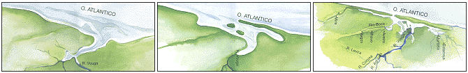
No século X, desde Espinho ao Cabo Mondego, o Atlântico banhava Esmoriz, Ovar, Estarreja, Aveiro, Ílhavo, Vagos e Mira formando o litoral ali uma baía de pequena reentrância. Entre Cacia e Angeja desembocava um vasto estuário no qual desaguavam os rios Vouga, Águeda e Cértima, e onde as marés do Oceano entravam livremente, alimentando de água salgada as inúmeras marinhas de sal que nos recôncavos das suas margens existiam, nomeadamente em Alquerubim e Eixo.
Vários documentos existem, contudo, que levam a situar por volta do século X o início da sedimentação operada sob a acção dos agentes naturais, que havia de transformar a baía existente na laguna de Aveiro e nos vastos areais de Mira. As narrações que registam o fenómeno permitem segui-lo, no seu evoluir constante, ao longo dos nove séculos que ele durou.
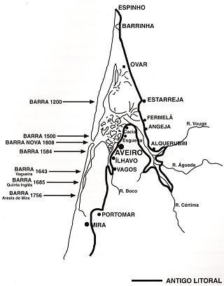
Partindo de Esmoriz para Sul um novo litoral começou, então, a formar-se e o cordão de areias que o definia começou a diferenciar-se, embora lentamente, do litoral antigo. Assim, por volta de 1200, já a barra vinha fixar-se por altura do ponto onde hoje é Torreira e aí se manteve durante quase todo o século XIII.
Mas, a acção dos agentes externos não pára: o mar, por um lado e os rios Antuã, Vouga, Águeda, Cértima e Boco que desaguavam na baía, pelo outro, não cessam de lançar o produto do seu desgaste na incipiente laguna e no estuário, cujo fundo se vai alteando para cota cada vez mais elevada.
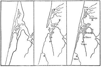
O cordão dunar continua o seu avanço para Sul, atingindo, no século XV, a região perto da qual hoje se situa a ermida de Nossa Senhora das Areias [São Jacinto], onde a barra se veio fixar durante algum tempo. No final do século XV o cordão dunar, que formava o novo litoral, situava-se já por alturas de Costa Nova do Prado, fazendo-se a entrada na laguna pelo canal, agora existente, entre a duna do litoral e as grandes dunas da Gafanha.
No tempestuoso inverno de 1575, o cordão litoral continuou a sua marcha para sul, ultrapassando as dunas da Gafanha e um violento temporal entulhou a barra com as areias. Em 1584 a barra continuava ainda por alturas da Costa Nova, muito embora o cordão litoral continuasse a sua progressão para Sul.
Mas, em 1643, a barra desaparece da Costa Nova para surgir na Vagueira; e, 40 anos depois, em 1685, ainda mais para Sul, na Quinta do Inglês. Entretanto o fenómeno natural continua o seu avanço para sul e nos meados do século XVIII a barra atingiu os areais de Mira, vindo a fechar-se completamente em 1757.
Desde aí até que, em 1808 (51 anos depois), quando a barra foi finalmente aberta, várias tentativas frustradas foram efectuadas para a fixar. Perto do local onde hoje se encontra, na Vagueira ou em Mira os esforços de abrir uma barra foram sempre em vão.
No entretanto, com o seu fecho completo, a laguna encheu e, como consequência, ocorreu a submersão das ilhas e campos marginais e a inundação da parte baixa de Aveiro. Isto levou a que Ria se tornasse num lago de água fétida e fonte de doenças como o paludismo e contribuísse para a degradação da economia local, pois o comércio, produção de sal, pesca e agricultura sofreram todos com a falta de comunicação com o mar. No princípio do século XIX, em Aveiro, a crise tinha chegado ao seu auge e a miséria era geral.
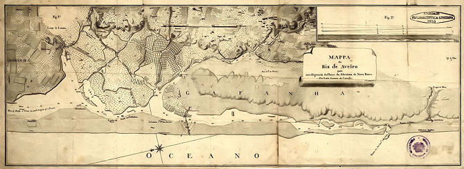
Para solucionar a situação, em 3 de Abril de 1808 foi inaugurada a abertura do Canal da Barra que permitia a comunicação da Ria com o Atlântico e assim escoar as águas paradas, fonte de degredo.
Aveiro Sea Mouth
The word
Inselberg comes from the German meaning island-mountain as "
Insel" means island and "
Berg" mountain. They appear as islands of rock rising up from the generally flat surroundings. Volcanic activity or other processes may give rise to a body of rock resistant to erosion, inside a body of softer rock such as schist or limestone which is more susceptible to erosion. When the less resistant rock is eroded away to form a plain, the more resistant rock is left behind as an isolated mountain.
In the 10th century, from Espinho to Mondego cape, the Atlantic flowed along Esmoriz, Ovar, Estarreja, Aveiro, Ílhavo, Vagos and Mira forming the coastline in that area a bay of small cavity. Between Cacia and Angeja existed one vast estuary where the rivers Vouga, Águeda and Cértima flowed and where the ocean tides entered freely, feeding of salted water the innumerous saltworks that existed in the caves of its shores, namely in Alquerubim and Eixo.
Although, various documents exist that lead to place in the 10
th century the beginning of the sedimentation performed under the action of natural agents, that would transform the existing bay into the Aveiro lagoon and vast sandy area of Mira. Narrations registering the phenomenon allow to follow it, in its constant evolution, throughout the nine centuries it lasted.
Starting in Esmoriz and going South a new coastline started then to form and the sand cordon that defined it started to be distinguished from the old coastline, slowly though. This way, around 1200, the sea mouth settled near the point where today we can find Torreira and there stayed for almost all the 13th century.
But the action of the external agents do not stop: the sea on one side and the rivers Antuã, Vouga, Águeda, Cértima and Boco that flowed to the bay, on the other, don't cease to throw the result of its erosion in the incipient lagoon and estuary, which bottom raise more and more to a higher elevation.
The dune cordon continues its progress to South reaching, in the 15
th century, the area near the place where today stands the Nossa Senhora das Areias chapel [São Jacinto], where the sea mouth settled for a while. In the end of the 15
th century the dune cordon, that formed the new coastline, was already near Costa Nova do Prado and the lagoon entrance was done through the canal, existing today, between the coast dune and the big dunes in Gafanha.
In the tempestuous winter of 1575, the coastline cordon continued its advance to south, went beyond the dunes of Gafanha and a violent storm filled up the sea mouth with sand. Still, in 1584 the sea mouth was near Costa Nova, although the coastline cordon continued its progression to South.
But in 1643, the sea mouth disappeared from Costa Nova and came up in Vagueira; and, 40 years later, in 1685, even further south, in Quinta do Inglês. In the meantime the natural phenomenon continues its progression to South and in the middle of the 18
th century the sea mouth reached the sands of Mira, closing itself completely in 1757.
Since then until when, in 1808 (51 years later), the sea mouth was finally open, numerous frustrated attempts were carry out to settle it. Near the place where it is nowadays, in Vagueira or in Mira the efforts to open a sea mouth were always in vain.
In the meantime, with its complete closing, the lagoon filled and, as consequence, the submersion of islands and marginal fields and the flood of the lower part of Aveiro occurred. This made the Ria to become a lake of fetid water and source of diseases like malaria and contributed to the degradation of the local economy, since commerce, salt production, fishing and agriculture all suffered with the inexistence of a connection with the sea. In the beginning of the 19th century, in Aveiro, the crisis had reached its peak and misery was generalized.
To solve the situation, in the 3
rd of April of 1808 the opening of the Sea Mouth Canal was celebrated and this permited the connection between the Ria and the Atlantic and thus drain the stagnant waters, source of degradation.