Pololu Valley EarthCache
-
Difficulty:
-

-
Terrain:
-

Size:  (not chosen)
Please note Use of geocaching.com services is subject to the terms and conditions
in our disclaimer.
**************IMPORTANT: In order to claim this as "found", you must complete the logging requirements at the bottom of the page.****************This is not your typical geocache, it is an EarthCache, you will not be looking for a "cache container" rather, an EarthCache is designed to bring you to a geological feature. See http://www.earthcache.org/ for further details.

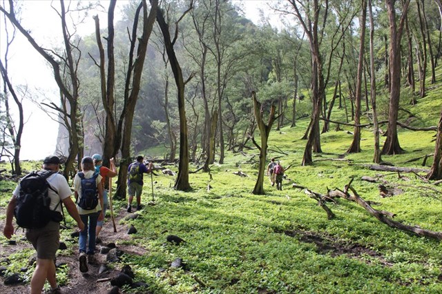
To log this EarthCache you will need to visit Pololu Valley. Your walk down the somewhat steep dirt path will be well worth the effort as you'll be rewarded with breathtaking views. Park at the end of the road at the listed coordinates. The Awini trailhead begins at the very end of the road and continues down to the valley. Trails criss-cross along the valley below and you're welcome to search for the traditional caches down below as you're exploring the valley. Please note that this beach is not suitable for swimming or snorkeling as the tides can be dangerous at this location. But feel free to enjoy wandering this lush valley and the black sand beach, mixed with a little Olivine as well. The Awini Trail crosses the valley floor, up the ridge and over to the Honokane Nui Valley. For this EarthCache you'll only need to visit Pololu Valley and observe the wetlands and stream.
About Pololu Valley
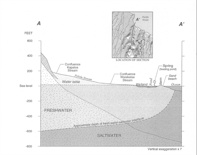
Pololu Valley runs in a north-south direction, is approximately 4 miles long and 2,000 feet wide. At it's greatest depth Pololu Valley is 1,400 feet. The sea cliffs rise to 400 feet as they meet the ocean. Pololu Valley is on the northeast side of the Kohala Volcano. The water table in the valley is close to the ground surface and it's fed by the Pololu Stream. All this water needs a place to go so it is naturally regulated by the wetlands in the valley.
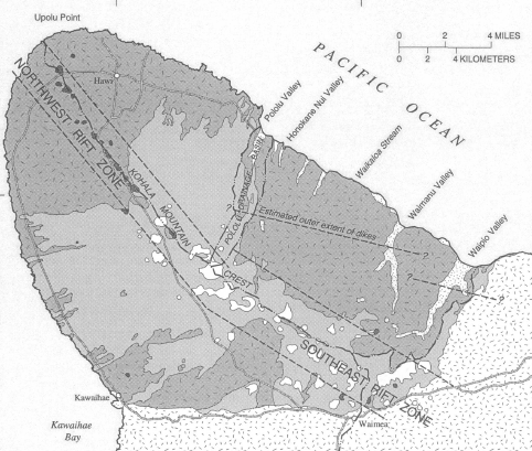
Kohala Volcano
Kohala Volcano is elongated and asymmetrical, and reaches a maximum altitude of 5,605 ft. The mountain affects the weather patterns surrounding it. The northeastern, windward side of the mountain where Pololu Stream flows is cool and wet, receiving more than 160 in/yr of rainfall near the summit (Giambelluca and others, 1986). The southwestern, leeward side is in the rain shadow of the summit, receiving less than 10 in/yr in the driest areas.
Geology of Pololu Valley
Almost all of Kohala Volcano is composed of thousands of flows and intrusions of the Pololu Volcanics. The aa and pahoehoe flows of the Pololu Volcanics dip away from the rift zones at about 3 to 10 degrees (Stearns and Macdonald, 1946). The flows range in thickness from several feet to about 50 ft. Above the flows is a layer of red soil, which is more porous than the bare aa flows on other parts of the volcano. Pololu Stream cuts into all of the soil levels on it's way to the wetlands. In the wetland and pond area at the terminus of Pololu Stream near the ocean, the composition of the alluvium changes from a black to dark-brown sandy mud upstream to a silty sand at the ocean end of the pond. At the shore, the beach face and berm is composed of sand, lava boulders, and cobbles. The black volcanic sand of the berm grades into a silty sand towards the pond.
Pololu Stream
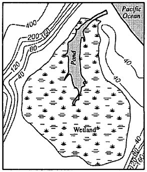
Except for times when there is a higher amount of water flow, Pololu Stream does not meet the ocean. During your visit please find the Pololu stream bed and note it's current state. About 2,000 feet from the ocean Pololu stream encounters wetlands, the valley's natural way of regulating the water. The wetlands are a shallow, brackish pond surrounded by reeds and grasses. The wetland terminates against a beach berm about 200 ft from the ocean. All this water makes for a very lush environment.
To get credit for this Earthcache please complete the following logging tasks. Please send me a message with your answers, not in your log. Please be careful not to post pictures with the ropes in them as it would spoil that part of the logging requirements for others.
1. Observe the stream bed. Is the stream flowing or is it dry? How wide is the stream? What does this mean for the wetlands? Why doesn't the valley maintain a constant channel to the ocean?
2. Does Pololu Valley receive the majority of the rainfall or is it in a rain shadow? What kind of environment grows here because of this?
3. Observe the soil particles at the beach and around the stream. Is this mostly made up of large particles or fine silt and sand? Consider the bedrock under the layer of soil. Why does the rain water collect here instead of soaking into the ground and disappearing? Is it porous or solid?
4. Please verify your presence by visiting the listed waypoint where you will find a sign. What is the purpose of that sign? Also, very near this sign is a wide rope swing. Please tell me the colors of the two different ropes on the sides.
Uploading photos of your experiences here would be appreciated but it is not required.
This information is courtesy of the USGS (United States Geological Survey) in cooperation with the County of Hawaii Department of water.
Additional Hints
(Decrypt)
Fbzr bs gur nafjref pna or sbhaq va gur pnpur qrfpevcgvba naq fbzr jvyy or sbhaq ol znxvat bofreingvbaf ba fvgr.