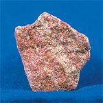
Sandstone
Sandstone (also known as arenite) is a clastic sedimentary rock composed mainly of sand-sized minerals or rock grains.
in: aquavision.wifeo.com/pierres.php
Most sandstone is composed of quartz and/or feldspar because these are the most common minerals in the Earth's crust. Like sand, sandstone may be any colour, but the most common colours are tan, brown, yellow, red, gray, pink, white and black. Rock formations that are primarily composed of sandstone usually allow percolation of water and other fluids and are porous enough to store large quantities, making them valuable aquifers and petroleum reservoirs. Fine-grained aquifers, such as sandstones, are more apt to filter out pollutants from the surface than are rocks with cracks and crevices, such as limestone or other rocks fractured by seismic activity. Although sandstone can harbour petroleum reservoirs, it is very unlikely that fossils can be found in them, due to the energetic environments where it is formed. The sand grains in sandtone can point ot interesting geological infformation, like marine currents, wind directions and past environments.

Arenito
O arenito é uma rocha sedimentar composta por minerais de tamanhos de grãos de areia ou outros minerais maiores.

in: proprofs.com
A maioria dos minerais presentes no arenito são quartzos e feldespatos, sendo também os mais abundantes na crosta terrestre. Tal como a areia, o arenito pode ter várias cores, sendo as mais comuns o castanho, amarelo, vermelho, cinzento, cor-de-rosa, branco e preto. As formações rochosas que são compostas principalmente por arenito permitem a infiltração de água e outros fluídos em grandes quantidades, sendo por isso valiosos aquíferos e reservas de petróleo. Aquíferos de grãos finos, como os de arenito são melhores a filtrar poluentes que rochas com rachadelas e falhas, tal como o calcário ou outras rochas fraturadas pela actividade sísmica. Apesar do arenito poder albergar reservas de petróleo, é pouco provável que haja fósseis impressos na rocha devido aos ambientes energéticos onde esta se forma. Os grãos de areia no arenito podem revelar aspectos geológicos bastante interessantes, tais como correntes marinhas, direcções do vento e climas passados.
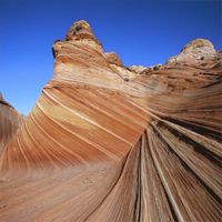
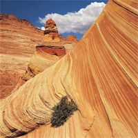
Sandstone Formation
They are formed from cemented grains that may either be fragments of a pre-existing rock or be mono-minerallic crystals. The cements binding these grains together are typically calcite, clays, and silica. Grain sizes in sands are defined (in geology) within the range of 0.0625 mm to 2 mm (0.002–0.079 inches). Clays and sediments with smaller grain sizes not visible with the naked eye, including siltstones and shales, are typically called argillaceous sediments; rocks with greater grain sizes, including breccias and conglomerates are termed rudaceous sediments. The formation of sandstone involves two principal stages. First, a layer or layers of sand accumulates as the result of sedimentation, either from water (as in a stream, lake, or sea) or from air (as in a desert). Typically, sedimentation occurs by the sand settling out from suspension; i.e., ceasing to be rolled or bounced along the bottom of a body of water or ground surface (e.g., in a desert or erg). Finally, once it has accumulated, the sand becomes sandstone when it is compacted by pressure of overlying deposits and cemented by the precipitation of minerals within the pore spaces between sand grains. The most common cementing materials are silica and calcium carbonate, which are often derived either from dissolution or from alteration of the sand after it was buried. The environment where it is deposited is crucial in determining the characteristics of the resulting sandstone. Principal environments of deposition may be split between terrestrial and marine:
Terrestrial environments
Marine environments
-
Deltas
-
Beach and shoreface sands
-
Tidal flats
-
Offshore bars and sand waves
-
Storm deposits (tempestites)
-
Turbidites (submarine channels and fans)
in: nationalgeographic.com
Formação de Arenito
O arenito é formado por grãos cimentados de rochas pré-existentes ou então cristais de mono-minerais. O cimento que liga estes grãos é tipicamente calcite, barro e sílica. A dimensão dos grãos é definida (em geologia) entre 0.0625 mm até 2mm. Barros e sedimentos com grãos de tamanhos inferiores, não visíveis a olho nú, incluíndo os siltitos e folhelhos, são chamados sedimentos argilosos. As rochas de tamanhos maiores, como as "breccias" e os conglomerados são denominados sedimentos "rudaceous". A formação de arenito processa-se em duas fases; primeiro uma ou várias camadas de areia acumula-se como resultado da sedimentação, através dá água (um rio, lago ou mar) ou do ar (deserto). Tipicamente, a sedimentação ocorre pela deposição da areia, ao parar de ser rebolada ao longo da base de um sistema aquático. Finalmente, após acumulação, os depósitos são cimentados e forma-se o arenito quando a areia é compactada pela pressão de camadas superiores e os depósitos são cimentados pela precipitação de minerais nos poros, entre os grãos de areia. Os materiais de cimentação são geralmente silica e carbonato de cálcio, que resultam da dissolução ou alteração da areia após sedimentação. O ambiente em que se deposita a areia é crucial na determinação das características do arenito resultante. Os principais locais de de deposição podem ser terrestres e aquáticos:
Ambientes terrestres
-
Rios
-
Encostas aluviais
-
Resíduos glaciais
-
Lagos Desertos
Ambientes aquáticos
-
Deltas
-
Praias
-
Planícies de marés
-
Ondas de areia
-
Depósitos de tempestades
-
Fumarolas submarinas
in:idvvt.blogspot.com
Chemical and Physical Properties
Sandstone is very resistant to acids, alkalies, thermal impact and physical preassure. The most important aspects are presented in the table below.
| Color |
Minor color tonal variations exist but within the tolerance limit |
| Hardness |
6.5 to 7 on Moh's Scale |
| Density |
2.3 to 2.4 Kg/cm3 |
| Compressive Strength |
90 to 140 N/mm2 |
| Modulus of Rupture |
16-40 N/mm2 |
| Water Absorption |
1.0 - 1.2 % |
| Porosity |
Low to very low |
| Weather Impact |
Resistant |
Propriedades Fisico-Químicas
O arenito é muito resistente a ácidos e bases, bem como a impacto térmico e pressão. As propriedades mais relevantes são apresentadas na tabela abaixo.
| Cor |
Algumas variações nos tons de cores |
| Dureza |
6.5 a 7 na escala de Moh |
| Densidade |
2.3 a 2.4 Kg/cm33 |
| Força Compressiva |
90 a 140 N/mm2 |
| Modo de Ruptura |
16-40 N/mm2 |
| Absroção de Água |
1.0 - 1.2 % |
| Porosidade |
Baixa a muito baixa |
| Impacto meteorológico |
Resistente |
The Earthcache
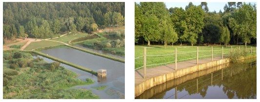
The published coordinates will take you to a wall that is made of sandstone, near a big lake known as the Pateira de Fermentelos. This sandstone wall belongs the long narrow rock that circles the rivers Vouga and Águeda; it's called the Sandstones of Eirol. It estimated that the formation of these rocks occurred around the Superior Triassic, between 213 and 219 Million years ago (when dinosaurs still inhabited the earth (and there were no geocaches around)). The study of these rocks helped geologists determine the tropical climate in that era, which alternated between abundant showers and extreem drought.Today, some houses are still built with some of these sandstones, namely in Óis da Ribeira, Espinhel, Travassô among others. Further reading
in: freguesiadeespinhel.pt
There is a tarmac road that takes the geocacher about 100 meters away from the cache. It is easily accessible by foot from there. To log this find, please respond to the following questions, and send us an email with the answers:
-
How tall and how long is the wall?
-
What color is it?
-
If you pass your hand of the wall's surface is it rough or soft?
-
Can you break a piece off?
-
By reading the sign next to the wall, please tell us in what era this wall was formed.
-
If you want, please upload a photo of you in front of the wall (optional)
A Earthcache
As coordenadas publicadas irão levar o geocacher a uma parede de arenito, perto do lago, conhecido por Pateira de Fermentelos. Esta parede de arenito faz parte de uma estreita faixa de rocha que circunda os vales dos rios Vouga e Águeda, designados "Arenitos de Eirol". Estima-se que a formação destas rochas tenha ocorrido durante o Triássico Superior, entre 213 a 219 Milhões de anos (quando os dinossaurios ainda habitavam o nosso planeta (e não havia geocaches ainda)). A avaliação destas rochas ajudou a caracterizar o clima tropical de então, que se caracterizava por temperaturas altas, com uma estação de chuvas abundantes e outra de seca extrema. Hoje, é ainda possível encontrar casas que têm na sua constituição rochas dos "Areitos de Eirol", nomeadamente nas freguesias de Óis da Ribeira, Espinhel, Travassô entre outras. Mais informação.
Há uma estrada de acatrão que leva o geocacher até cerca de 100 metros da cache, e para chegar a esta há um caminho de fácil acesso. Para fazer o log desta cache, envie-nos um email com a rsposta às seguintes questões:
-
Qual é a altura e o comprimento estimado da parede?
-
Qual é a cor da parede?
-
Se passar a mão pela superfície da parede, esta é rugosa ou lisa?
-
É fácil partir um bocado do arenito?
-
Ao ler o placard perto da parede, diga-nos em que era esta parede foi formada.
-
Opcionalmente podem fazer upload de uma foto vossa em frente à parede.