|

|

|
 |
| Glacier Valley |
|
Vale Glaciar |
| Glaciers carve some of our planet's most spectacular scenery, but it's not until glaciers melt that their rasping handiwork is exposed. |
|
Os glaciares esculpem algumas das paisagens mais espetaculares do nosso planeta, mas só depois de os Glaciares derretem é que a sua obra é exposta. |
|
|
|
| Glaciers and running water sculpt the land in different ways. While streams tend to cut winding curves and V-shaped valleys, glaciers carve nearly straight valleys with U-shaped cross-sections. The imposing, sheer rock walls of glacial troughs (U-shaped valleys) are among the most fundamental and distinctive features of glaciated landscapes. The U-shaped valleys left behind by valley glaciers are usually 1 kilometer or more in width and typically hundreds of meters high. |
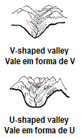 |
Os Glaciares e a água corrente esculpem a terra de maneiras diferentes. Enquanto as correntes de água tendem a cortar curvas sinuosas e vales em forma de V, os Glaciares esculpem vales quase retos em forma de U com secções transversais. As imponentes, paredes rochosas de calhas glaciares (vales em forma de U) estão entre as características mais fundamentais e distintivas das paisagens glaciares. |
|
|
|
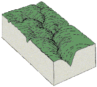
| Start with a typical stream |
|
Começa com um típico vale de água corrente |
As streams wind their way downstream they tend to cut away the outsides of bends and deposit sediment on the insides of bends. This gradually makes the stream valley more sinuous.
Running water gradually cuts a deeper V-shape. The end result is a typical meandering, V-shaped stream valley. |
 |
As correntes que abrem caminho rio abaixo tendem a cortar as laterais das curvas e de depositar sedimentos no interior das curvas. Isso faz com que gradualmente o vale fique mais sinuoso.
Água corrente gradualmente corta uma profunda forma de V. O resultado final é um típico sinuoso, vale fluxo em forma de V.
|
|
|
|
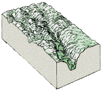
| Glaciers move in |
|
O Glaciar aparece |
| Climate cools and glaciers grow and begin their slow downhill push, usually taking the easiest path down - the path already cut by streams. Glaciers ooze into stream channels, but unlike streams, glaciers focus their grinding energy on the insides of bends. Bit by bit, the glacier eats away at the meandering curves of the original stream valley, carving a wider, straighter valley. |
 |
O clima arrefece o Glaciar cresce e começa sua lenta descida, geralmente segue o caminho mais fácil para baixo - o caminho já cortado pelas correntes de água. Os Glaciares escorrem pelos canais formados pela corrente de água, mas ao contrário dessa corrente, os Glaciares concentram sua energia na moagem do interior das curvas. Pouco a pouco, o Glaciar corrói as curvas sinuosas do vale de fluxo original, esculpindo um vale maior e mais reto. |
|
|
|
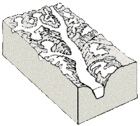
| Work of a glacier revealed |
|
O trabalho de um Glaciar é revelado |
| During times with warmer climate like today's (called interglacial periods), glaciers gradually melt away except at high elevations and latitudes. As glaciers melt, their effect on the landscape is revealed. Former stream valleys have been transfomed to broad, very steep-sided troughs and waterfalls cascade from hanging valleys perched high above the valley floor. |
 |
Durante épocas com clima mais quente como o actual (chamados períodos interglaciais), os Glaciares derretem gradualmente, exceto em altas altitudes e latitudes. Com o derretimento dos Glaciares o seu efeito sobre a paisagem é revelado. O vale de fluxo original foi transformado num vale largo muito íngreme. |
|
|
|
| Zêzere Glacier Valley |
|
Vale Glaciar do Zêzere
|
This is the largest glacial tongue in the Serra da Estrela, measuring 13km in length.
It is easy to observe the place where the glacier went past the present town of Manteigas, melting at an altitude of around 680m. The enormous length of the glacial valley is due to the fact that it was fed successively by the tongues of the St. Anthony’s Nave, Ametade Hollow, Candieira and Hollows. |
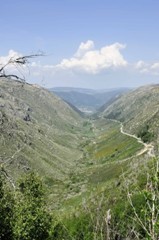 |
O Vale Glaciar do Zêzere corresponde à língua glaciária de maior dimensão da Serra da Estrela, atingindo os 13 km de extensão .
Pode ser facilmente observado o local em que o glaciar ultrapassava a zona da actual vila de Manteigas, tendo-se dissolvido a cerca de 680 m de altitude. O enorme comprimento do vale glaciário, deve-se ao facto de ter sido alimentado pelas línguas da Nave de Santo António, Covão da Ametade, Candieira e Covões , progressivamente. |
|
|
|
| The EarthCache |
 |
A EarthCache |