Brown's Folly - Jurassic limestone outcrops EarthCache
Brown's Folly - Jurassic limestone outcrops
-
Difficulty:
-

-
Terrain:
-

Size:  (other)
Related Web Page
Please note Use of geocaching.com services is subject to the terms and conditions
in our disclaimer.
Investigate a series of well exposed Jurassic rock outcrops
Brown’s Folly Nature Reserve consists of 91 acres of land on the hillside overlooking the valley of the River Avon about half a mile south-east of the village of Bathford. It is owned by the Avon Wildlife Trust and has been designated as a site of special scientific interest (SSSI) because of the Middle Jurassic rocks, plants and wildlife that can be found there. The EarthCache is here with the permission of The Reserves Manager, Avon Wildlife Trust
The diagram below will help you identify the various rocks making up the cliff face in front of you.
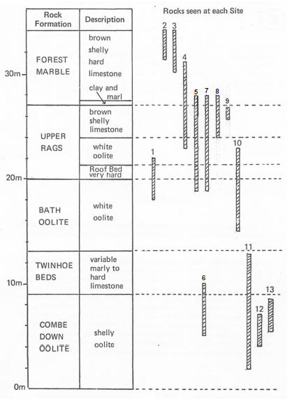
This is Site 5 on Brown's Folly Nature Reserve. (For those of you who have done the EarthCaches at Sites 1 and 2 on this trail and are wondering what happened to Sites 3 and 4, the rocks in Site 3 are seen at Site 2 and those in Site 4 are inaccessible.)
If you have visited Brown's Folly - old adit mine, (GC4CTH7), Site 1 on the geological trail, you will recognise the lower two rock strata at this site. At the base was the Bath Oolite limestone but it has been quarried out and is the bricked-up entrance to the old adit mine. (Adits are mines which go directly into the hillside). It is overlain by the Upper Rags - Roof Bed (the coral-rich layer used by the quarrymen as the roof for their adit mines). Above the Roof Bed is a white oolite looking much like the Bath Oolite below it and indicates a return to the same sort of environment that existed before the Roof Bed was deposited.
The grid in the blocked-up entrance to the mine is to allow the threatened Greater Horseshoe Bats free access.
If the white oolite above the roof bed is examined carefully, and this can be done at a small rock face to the left of the main face, it will be found to be more shelly than the Bath Oolite and to also have the remains of small vertical burrows in it. The burrows show that there were some organisms living in the oolite (probably bivalves) indicating that there were periods of stability during the deposition of the oolite that enabled organisms to become established. This oolite was not mined on the reserve but was mined to the east near Bradford-on-Avon where it is less shelly. It was worked as a building stone and known as Bradford Ground stone or Bethel stone.
This stone and the Bath Oolite are examples of freestones, so called because they are free from fossils and flaws and also can be cut freely in any direction without fear of a split in an unwanted place. They are soft enough to be cut with a hand saw but harden on exposure to the atmosphere.
Above the oolite are the top beds of the Upper Rags. These can be examined more easily at the next waypoint.
What to do:
1. Identify the rock layers and estimate their thicknesses.
Now walk along the outcrop to Waypoint 2 - N 51 23.625 W 002 17.827, Site 7 on the geological trail. (Site 6, is further down the hillside from site 5 but the same geology can be seen at Site 11. The rocks at Site 7 are the same as those seen previously at Site 5 but are more accessible for examination.
Identify the Roof Bed and the Bath Oolite below and the white oolite and the hard, honeycomb-weathered, brown shelly limestone bed above.
Examine the oolite above the Roof Bed. It contains clear burrow structures. Compare it with the Bath Oolite below.
There is a large scree at the base of the rock face and some of the material contains whole fossils while much of it contains fragments of shells. This is a very good place to hunt for fossils. Lots of bivalves (cockles, mussels, oysters) have been found. Some brachiopods (lamp shells), echinoids (sea urchins) and crinoids (sea lilies) have also been found.
A track up the left hand side of the site enables the highest beds of the Upper Rags and their junction with the Forest Marble (seen if you have been to Brown's Folly - shelly limestone GC4D9KJ Site 2 on the trail). Just below this junction there is a conspicuous brown clayey band from which fossils characteristic of the Bradford Clay can be obtained. Please take extra care here as the slope is steep.
What to do:
1. Collect samples of the two oolites and compare them. What are the main differences?
2. How can you distinguish between rocks from the Roof Bed and those from the oolite beds?
3. It would be lovely to see some photos of your investigation but this is optional!
Walk along the outcrop to Waypoint 3 - N 51 23.653' W 002 17.821', Site 8 on the trail
At the base of this rock face you can see the white oolite, but above it, there is a deeply weathered rubbly rock. Please do not hammer this rock but examine the rock face and fallen blocks carefully to see if you can find anything that may give you a clue as to the environment in which it was formed. The rock is clearly unlike any seen at the other sites visited and its nature is best shown when a piece is cut and polished or examined as a thin section of rock under a microscope, but a diligent search in the scree could produce a block showing the features illustrated. In fact this is a small patch of coral - a patch coral reef.
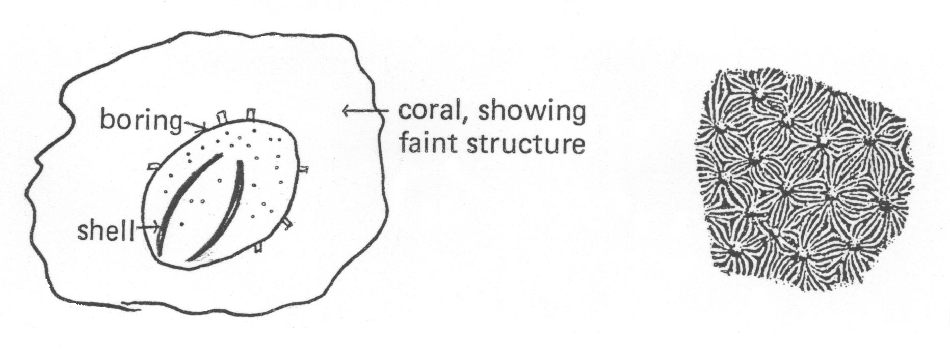 The illustration on the left shows that the coral had been bored into; amazingly a brachiopod shell has been preserved in the burrow.
The rock to the right of the face just to the side of the rough path should be examined carefully. This rock is made up of varying sized blocks and represents the debris that fell down the side of the coral reef.
If the rough path up the face is climbed, the junction between the reef and the bed that was laid down above it can be examined. The reef with patches of debris extends for about 40m at this level but is not easily accessible.
On your way to the next waypoint, admire the view to your west. You can imagine that before river erosion, the rocks where you are standing continued all across the valleys and joined up on the other side; the bedding of the strata is almost horizontal. The valley immediately in front of you was carved by the Bristol River Avon on its way from Bradford on Avon through the Limpley Stoke gorge to Bath. Can you see that it turns nearly at right angles below on your right, to continue to flow towards Bath? It is joined here by its tributary the By Brook.
Waypoint 4: N 51 23.666 W 002 17.822, Site 9,
Examine the sides of this block carefully. Have you seen the type of markings shown here before? (Please refer to Brown's Folly - shelly limestone GC4D9KJ, Site 2 on the trail.) On the sides of this block, the cross-bedded structure is clearly seen and as the block shows two faces nearly at right angles a more complete picture of the depositional process can be obtained. Cross bedding is a very important geological feature (sedimentary structure) as it enables the direction of the water depositing the rock forming sediment to be deduced and also, by analogy with structures found in the sediments of modern rivers and shore lines, enables deductions about past environments to be made. Notice how the direction of slope of the cross bedding reverses at times and sometimes cuts across lower layers. This indicates a varying direction of flow of the depositing current and at times erosion of existing sediments.
What to do:
Can you work out the direction of flow? As you face the block, was it left to right or right to left?
Waypoint 5: N 51 23.709 W 002 17.837, Site 10
You will no doubt recognise the rocks here as the Bath Oolite overlain by the Roof Bed and white oolite, (here the latter is very shattered). The special interest at this site is the mine and the way the rocks have moved. The mine only penetrates a short way into the hill; the reason for this seems to have been that a fissure, seen at the left hand side of the back wall of the mine, made the stone of poor quality or unworkable. Although the mine is little more than an entrance, it does give some idea of what a mine was like and shows inside the greatest continuous thickness (4.5m) of Bath Oolite seen so far.
Stand back from the face and, using the Roof Bed as a marker band, see if you can deduce how the rocks have moved.
The Roof Bed exposed across the main face has tilted down to the right and three breaks (faults) have occurred in it leaving two isolated blocks at different levels. There are indications that there was once a mine entrance at the right hand corner of the face and it is possible that the Roof Bed broke and collapsed down to the position in which we see it now. A current of air can be felt at the crack nearest to the main face supporting the suggestion that there is an old mine below, but the rock movement may have been due to movement along faults (cracks in the Earth's surface, often caused by earthquakes).
What to do:
Estimate the amount of movement on these faults.
Additional Hints
(Decrypt)
Gur fvgrf zragvbarq ner nyy ba gur yrsg bs gur znva cngu sebz gur pne cnex