 Deutsch / German
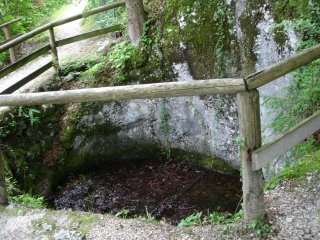
Gletschertöpfe sind runde Vertiefungen im Felsgestein und entstanden während der letzten Eiszeit, die vor ca. 10.000 Jahren zu Ende ging. Zu dieser Zeit war das Berchtesgadener Land von einer mehreren hundert Meter dicken Eisschicht bedeckt - einem Gletscher.
Durch Eisspalten stürzte Schmelzwasser zu Boden und höhlte den Fels allmählich aus. Mitgeführter Sand, Kiespartikel und manchmal auch Findlinge verstärkten den Effekt. Im Laufe der Zeit wurde die Vertiefung größer und es bildeten sich Wirbel mit Fließgeschwindigkeiten von bis zu 200 km/h und hohem Druck. Das mitgeführte Gestein wirkte dabei stark erodierend und höhlte den Fels immer tiefer aus.
Oft sind noch Findlinge in den Gletschertöpfen zu sehen, die die Erosionsarbeit veranschaulichen. Gletschertöpfe sind vorwiegend dort zu finden, wo es Gletscher gab oder gibt.
Vor Ort findest Du zwei Gletschertöpfe direkt nebeneinander und eine Infotafel. Wenn Du die Treppe hinter Dir heruntergehst, findest Du bei N47 37.995 E012 59.965 einen weiteren Gletschertopf.
Um den Earthcache zu loggen, beantworte uns bitte folgende Fragen:
1) Wie ist die Oberfläche der Gletschertöpfe? Eher glatt oder eher tief zerfurcht?
2) Ist die Form der Gletschertöpfe rund oder oval?
3) Im unteren Gletschertopf liegt ein grosser Stein. Ist der Deiner Meinung nach später hier hereingefallen oder hat er dazu beigetragen, den Gletschertopf zu bilden und warum?
4) Schätze den Durchmesser des unteren Gletschertopfes von links nach rechts.
Sende uns die Antworten zu den Fragen über unser Profil zu. Du brauchst keine Logerlaubnis von uns abzuwarten. Bei falschen Antworten melden wir uns.
Über ein - natürlich optionales und freiwilliges - Foto im Log von dir oder Deinem GPS am Gletschertopf würden wir uns sehr freuen.
 Englisch / English
Glacier potholes are round cavitys in rock and are formed during the last glacial period, which came to end about 10.000 years ago. At this time the Berchtesgaden area was covered by a several hundred meters thick layer of ice - a glacier.
Meltwater fell to the ground through crevasses and hollowed the rock gradually. Carried sand, gravel particles and sometimes boulders too enhanced the effect. In the course of time the cavity increased and vortexes with a flow velocity up to 200 km/h and high pressure arised. The carried rock worked highly erosive and hollowed the rock deeper and deeper.
Often are still boulders in the glacial potholes to see which illustrate the erosion. Glacier potholes are mostly to find where glaciers are or have been.
On the spot you will find two clacier potholes side by side and an (German only) information board. Moving downstairs behind you there is a third glacier pothole at N47 37.995 E012 59.965.
Please answer the following questions to log the earthcache:
1) How is the surface of the potholes? Is it rather even or rather highly rugged?
2) Is the pothole round or oval shaped?
3) There is a boulder in the lower pothole. What is your opinion? Did it fell later into the pothole or did it help forming the pothole and why?
4) Guess the diameter of the lower glacial pothole from left to right.
Please send the answers via our profile. You don't have to wait for log permission. We will contact you if answers are incorrect.
We would be very glad if you include a photo (of course voluntary and optional) from you or your GPS at the location.