Shoreham-by-Sea enjoys a unique location, bordered on the north by the South Downs Area of Outstanding Natural Beauty, on the west by the open valley of the River Adur and on the south by the river and Shoreham Beach. The town and port of New Shoreham was established by the Norman Conquerors towards the end of the 11th century. Shoreham’s strategic location and proximity to Normandy made it a logical place to improve facilities for travel and trade. Shoreham Beach, to the south of the town, is a shingle bank thrown up over the centuries by the sea through a tidal process as an extension to Lancing parish in the west. This blocks the southerly flow of the River Adur which turns at this point to discharge into the English Channel further along the coast at a point that has varied considerably over time.
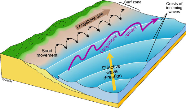
The transport of sand and pebbles along the coast is called longshore drift. The prevailing wind (the direction the wind ususally blows from) causes waves to approach the coast at an angle. The swash carries the sand and pebbles up the beach at the same angle (usually 45º). The backwash, however carries the material back down the beach at right angles (90°) as this is the steepest gradient. if a pebble was placed in the water it would be carried along the coastline in a zig-zag motion and would eventually be deposited when the waves lose energy. The general direction of longshore drift is decided by the prevailing wind. In the diagram below the prevailing wind is approaching from the south-west. Therefore longshore drift is moving material from the west to the east.
To log this cache just email the answers and post a picture of your visit to your log if you like.
1. The formation of the beach caused the river to divert in what direction.
2. What was formed in the area at the bend in the river because of its diversion.
3. What structures are now in place on the beach to stop erosion of the beach.(Not the Beach Huts) Walk along the beach to waypoint TASK4. What are the ones here constructed from.
4. From which direction was the beach formed. Examine the structures at waypoint TASK4 can you see a build up of shingle on one side more then another.
Please note this is an Earthcache, please submit your answers to me, logging 'found it' 'TFTC' or 'Thanks' log will be deleted.