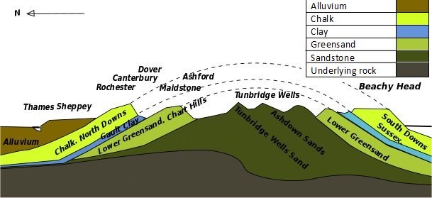
The North Downs are a series of chalk hills originally created from shells of creatures laid down when this area was under the sea during the Upper Cretaceous period. Subsequent geological activity lifted them at about the same time period as the Alps were formed in central Europe.Stronger uplift and folding occurred further west in places such as Dorset, where geological strata can be nearly vertical. The Needles are a classic example of this.
However here in Kent these chalk deposits were formed into an elongated dome shape, with the long axis in a roughly east-west direction. Subsequent erosion along this axis removed much of this chalk and in many areas has revealed the underlying Wealden deposits such as the sandstones at Hastings. These Wealden deposits have been found to be fossil-rich with several dinosaur remains.
 ........
An example of such erosion is seen here at Wye - The Devil’s Kneading Trough is a classic dry steep-sided valley formed by glacial action; in fact arguably the best such example in the South East. Here at Wye the geology is that of chalk uplands. Chalk remaining from the originally uplifted chalk dome forms the North and South Downs. The South Downs form picturesque cliffs in Sussex. Wye is part of the North Downs. Park up in the free car park, and enjoy the panoramic views. Look around, and see the shape of the land. Imagine how the great sheets of ice, the glaciers, formed the steep valley below you. Look into the distance – see how the shape of the hills funnels winds that blow along the English Channel into the wind farm that you can see in the distance.
To qualify for this Earthcache you need to visit the site and go for a short stroll. As you walk please bear in mind that this is a Site of Special Scientific Interest; you really must keep to the clearly marked footpaths. And after your stroll please email the cache owner the answers to the following questions:
Start off at the waypoint at the top of the slope. How high above sea level are you? Look around. Is there anywhere else nearby which is higher?
Spend a few minutes studying the terrain of the footpath at the top of the slope (waymarked). How deep is the topsoil? Is it muddy (or likely to get very muddy). Is the terrain very firm, or is there loose stones and rocks on the path? If there are, decribe them.
Set your sat-nav to the waymark at the bottom of the slope and stroll downhill. As you go look out for chalk outcroppings (there are a few). Is the chalk here uniform in appearence? Are there other rocks in the chalk? If so, describe them. And suggest how those rocks may have got into the chalk.
Once at the bottom of the slope consult your sat-nav. How high above sea level is the base of the Devil’s Kneading Trough? So how far down have you walked (and must walk back up again)?
Look at the terrain here. Is it muddy or firm compared with the terrain at the top of the slope? Describe the simularities and differences in the ground between the two locations, and suggest reasons for any differences between such a relatively short distance.
From the waypoint at the bottom of the slope you may carry on with your walk in several different directions. There are beautiful walks round here. Why not take a photo of the view and append it to the log of your visit? (Doing so is entirely optional) This cache is in place with the kind permission of Natural England