Sulphur Springs Earth Cache Site – Klamath National Forest
A Note of Encouragement
Welcome to the Klamath National Forest Earth Cache program! Most of the Earth Cache locations are away from established recreational trails and roads. Visitors are strongly encouraged to check with Ranger District offices for information on current road and trail conditions before visiting sites and be prepared for cross-country hiking.
Layered clothing, water, and appropriate maps are essentials when traversing the remote, rugged landscape of the Klamath National Forest. Please be aware of wildlife and poison oak while visiting Earth Cache locations in the forest and use caution when traveling on narrow winding forest roads.
Location Information
Sulphur Springs is located in the Happy Camp Ranger District.
In order to get to Sulphur Springs you will want to take Forest Road 16N05 (locally known as Elk Creek Rd), the site is in a campground 12 miles from Happy Camp. UTM location: 10T 0473296, 4612080 NAD 83.
Geological Information
Sulphur Springs lies within the Happy Camp/Oak Knoll Ranger District along Elk Creek in the Klamath Mountains Province which is made up of several mountain ranges: Trinity Alps, Marble Mountains, Salmon Mountains and Siskiyou Mountains. These mountains have an average elevation between 4,920’ – 6,888’ (1,500m – 2,100m). The rocks making up these mountains, the oldest in the east and the youngest in the west, are a mixture of accreted oceanic crust depicting a history of subduction.
Subduction happens when one tectonic plate is overridden by another. In Northern California, an oceanic plate was overridden by a continental plate. As the oceanic plate is descending into the mantle below the continental crust, water from the plate causes partial melting below the continental crust and a magma chamber is created (Figure 1).
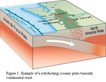
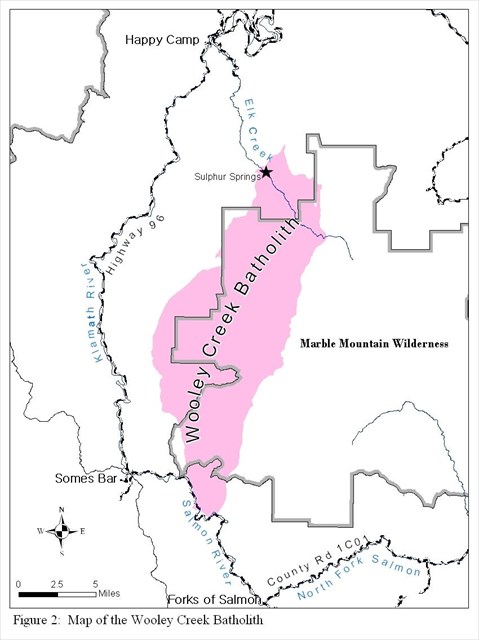
About 162 million years ago, this process began in the Klamath National Forest. Up to 25 miles (40 km) below the surface of the Earth a molten hot magma chamber began to form, squeezing its way up into weak portions of the crust. As subduction continued, the magma chamber was cut off from its heat source and eventually began to transition from molten rock to solid rock which can take millions of years. The Wooley Creek Batholith (a batholith is another word for a large solidifying magma chamber) was formed by this process. After millions of years of erosion, the Wooley Creek Batholith can be seen exposed in several places in the Klamath National Forest, including Sulphur Springs along Elk Creek. The exposed part of the batholith is just under 80,000 acres, but most of the batholith is below the ground and still cooling, like an iceberg, you just see the top of it (Figure 2).
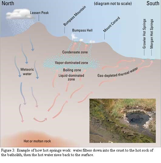
A hot spring is where groundwater seeps from a natural geothermal system in which the temperature of the water is above the average air temperature of the region. Hot springs form when water filters down deep into the crust though fractures to the hot rock around the batholith. This hot rock heats the water and it rises up on a long journey back through cracks to the surface where it bubbles out into Sulphur Springs (Figure 3). This is the same process that occurs in Yellowstone National Park and their many bubbling hot springs and geysers.
The warm water is a good environment for algae and bacteria to grow. The rotten egg smell is evidence of bacteria: they convert sulphur in the water to hydrogen sulphide (H2S), making the rotten egg smell. White algae are also present at Sulphur Springs, just below the developed pool see if you can spot some of it. The obvious springs are in the pool area, but look around the area both upstream, downstream and along the banks of Elk Creek for more springs, algae and bubbles.
Sulphur Springs are hot springs found right here in the Klamath National Forest. They are an important example of what we can see on the surface as evidence of much larger processes of subduction and plate tectonics.
Logging Questions:
- Name 3 indicators of the spring. Is there any other evidence of hot springs in the area?
- Which is warmer, the creek or the spring? Why do you think one is warmer than the other?
Resources
Harden, D.R., 2004, California geology, Pearson Prentice Hall, Upper Saddle River, N.J., 552 p.
Hanor, J.S., 1980, Fire in Folded rocks, National Park Service, www.nps.gov/hosp/naturescience/upload/inhotwater06-2.pdf
Kearey, P., 2001, Dictionary of Geology, Penguin Books, London, 327 p.
Sawyer, J.O., 2006, Northwest California: a natural history, University of California Press, Berkeley, CA, 247 p.
Geysers, fumaroles and hot springs, pubs.usgs.gov/gip/volc/geysers.html
Mountain Nature: a field guide for the next millennium, www.mountainnature.com/geology/HotSprings.htm.
Image references:
Subduction: http://earthquake.usgs.gov/learn/glossary/?term=subduction%20zone
Map
Hot Springs: http://pubs.usgs.gov/fs/2002/fs101-02/
Contacts
Happy Camp/Oak Knoll Ranger District
63822 Highway 96
Happy Camp, CA 96039
(530) 493-2243
FAX (530) 493-2212
TDD (530) 493-2894
Klamath National Forest
Supervisor’s Office
1711 South Main Street
Yreka, CA 96097-9549
(530) 842-6131
FAX (530) 841-4571
TDD (530) 841-4573