

No Local conhecido como a antiga Pedreira da Ladeira, situada nos Covões Largos, São Bento pertencente ao concelho de Porto de Mós foi descoberta uma Praia Jurássica.
A paisagem deste lugar, que é hoje a Serra de Aire e Candeeiros, era, há cerca de 170-166 milhões de anos (Jurássico Médio), uma planura litoral, pejada de zonas inundadas por lençóis de água, com um a dois metros de espessura.
Nessa altura, a Europa ainda se encontrava ligada ao continente norte-americano e, entre a Ibéria e a Terra Nova, no Canadá, penetrava um mar pouco profundo de águas tépidas e límpidas, propícias à formação de recifes de coral. O clima era quente e húmido e a vegetação exuberante.
Este tipo de testemunho geológico/paleontológico, está deste modo atestado nesta zona, pela pedreira da Ladeira em São Bento – Porto de Mós, onde podemos encontrar cerca de 2 mil metros quadrados de um antigo fundo marinho/praia, com inúmeras espécies de estrelas do mar, crustáceos, peixes, ouriços do mar, lírios do mar, sulcos feitos por animais marinhos e as próprias ondas do mar fossilizadas, (Ripple marks).
(Retirado de: http://www.municipio-portodemos.pt/NewsDetail.aspx?IdNoticia=261, by Dr. António José Menezes Teixeira)
Ripple Marks
Ou marcas de ondulação, são marcas deixadas sobre uma superfície pela ação da água ou do vento. As superfícies suscetíveis de preservarem estas marcas são constituídas de sedimentos finos como siltes e areias.
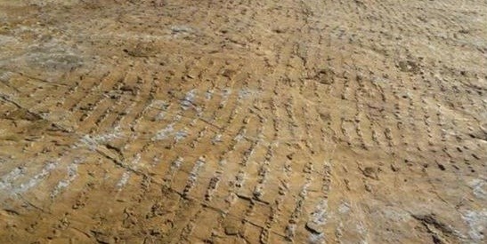
As marcas onduladas são estruturas primárias, que se formam quando os sedimentos estão inconsolidados e na superfície.
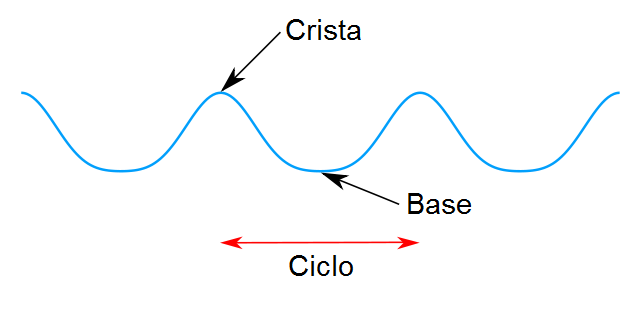
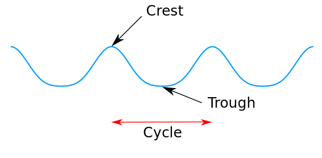
São de dois tipos: simétricas e assimétricas.
§ Ondulações simétricas: são produzidas por movimentos oscilatórios, onde o fenómeno causador, comumente a água, tem um movimento bidirecional. Estas ondulações constituem-se em excelentes indicadores do topo e base da camada, na medida que as cristas das ondas são mais agudas e apontam para cima.
§ Ondulações assimétricas: são tipicamente produzidas por movimento unidirecional, como correntes de água ou vento. São muito úteis para se determinar a direção e o sentido da paleocorrente que a produziu, pois o lado mais inclinado da ondulação aponta no sentido contrário do movimento, enquanto o lado mais suave orienta-se no sentido da corrente.
Definições:
Crista - Ponto da onda com o valor máximo de altura.
Base - O oposto de uma crista, ou seja o valor mínimo de altura de uma onda.
Sotavento - Direção para onde sopra o vento ou lado contrário de onde vem o vento. O sotavento tem uma inclinação mais acentuada do que o stoss. A corrente flui para o lado de sotavento.
Stoss - É o lado de uma onda ou ondulação que tem um declive suave em comparação com um declive mais acentuado. A corrente flui sempre da stoss para o sotavento. Isto pode ser utilizado para determinar o fluxo de corrente existente durante a formação destas marcas de ondulação.
http://www.dicionario.pro.br/index.php/Marca_de_ondula%C3%A7%C3%A3o
Neste contexto de biodiversidade paleontológica, passeavam-se nestas margens dum mar jurássico tropical a subtropical, dinossáurios, como aqueles que têm sido encontrados no Concelho de Porto de Mós e até aquele que foi identificado no Concelho da Batalha que vem provar que a Europa ainda se encontrava ligada ao continente norte-americano, ficando assim marcado num dos muitos estratos de calcário, do Maciço Calcário Estremenho.
É, pois, no fundo das lagunas litorais que se depositavam, constantemente lamas de calcário, onde facilmente ficavam impressos, estes testemunhos paleontológicos a que chamamos icnofósseis.
Na sequência da evolução geológica regional, esta área afundava-se constantemente permitindo a invasão das águas marinhas e a continuidade da sedimentação. Muito mais tarde houve deformação destes estratos do que resultou a elevação da Serra de Aire e Candeeiros, ao mesmo tempo que se afundava a Bacia Terciária do Tejo.
Neste contexto, é muito importante este sítio geológico, pela sua dimensão, raridade, beleza e acima de tudo pela sua geodiversidade (ou diversidade geológica) que é a variedade (a diversidade) de elementos e de processos geológicos, sob qualquer forma, a qualquer escala e a qualquer nível de integração, existente no planeta Terra (do grego gê, Terra + latim diversitate, diversidade).
Deste modo, a Assembleia Municipal de Porto de Mós, na sua sessão de 29 de Novembro de 2013, aprovou por unanimidade sob a proposta do Dr. António José Menezes Teixeira uma recomendação à Camara Municipal para se classificar o sítio em causa como Geo-Monumento pelos aspetos anteriormente citados.
Esta jazida geológica/paleontológica já estava referenciada há algum tempo, mas só agora, foi divulgada porque, por um lado a câmara municipal tem nos seus planos um Geoparque e por outro, porque está a ser objeto de estudo por parte de vários investigadores, no âmbito de uma tese de Doutoramento, com a colaboração da Universidade de Bristol – Reino Unido
(Retirado de: http://www.municipio-portodemos.pt/NewsDetail.aspx?IdNoticia=261, by Dr. António José Menezes Teixeira)
Contudo, a divulgação e investigação no local tem desencadeado algumas divergências devido às últimas decisões que foram tomadas.
Em janeiro, os presidentes da Câmara de Porto de Mós e da Junta de São Bento manifestaram indignação por o Instituto de Conservação da Natureza e Florestas (ICNF) ter autorizado o Laboratório Nacional de Energia e Geologia, a retirar do local fósseis de equinodermes - estrelas-do-mar, crinoides e ouriços-do-mar, alegando a necessidade de os salvaguardar da ação humana e meteorológica, dado que podem constituir, do ponto de vista científico, "exemplares tipo", isto é, exemplares importantes na definição de uma nova espécie ou no "muito melhor" conhecimento das espécies existentes.
Até ao momento foram retirados alguns exemplares do local, contudo está prevista uma reabilitação ao local, sendo que entre as ações previstas está a instalação de dois passadiços, um para a visitação da laje, e outro, na crista do talude, que permitirá uma visão superior sobre a laje e a paisagem envolvente e, também, a recuperação de uma ruína existente para apoio à visitação.
Atenuar o efeito erosivo das águas superficiais e colocar réplicas nos locais dos exemplares retirados são outros dos trabalhos previstos.
Foram, até à data, descobertos mais de 90 exemplares, sendo previsível a descoberta de mais. Segundo o ICNF os exemplares já encontrados/estudados possuem elevada importância científica, devido ao seu grau e modo de preservação, à sua idade e raridade, e à sua alta concentração no local. A mesma investigação poderá ainda levar à descoberta de novas espécies de equinodermes.
(Retirado de Jornal Diário de Notícias, por Lusa, publicado por Ana Maia, 16 Junho 2014)
Tal descoberta parece dar uma nova contribuição para o conhecimento da geologia e paleontologia regional, nacional e até internacional. Segundo José António Teixeira, "dada a raridade deste tipo de ocorrência de uma associação de fósseis de equinodermes articulados, isto é, ocorrendo com elementos do seu esqueleto preservados 'in situ', é, de facto, uma ocorrência singular e rara ao nível de jazidas de invertebrados do Mesozoico em Portugal e raríssimo em termos internacionais".
(Retirado de Jornal Diário de Notícias, por Lusa, 10 Dezembro 2013)
Para poder logar esta EarthCache, deverá responder às seguintes questões:
1 - Qual o tipo de fóssil existente no local das coordenadas?
2 - Qual o diâmetro desse mesmo fóssil?
3 - Estima o comprimento de um ciclo de onda das “Ripple marks” existentes no local.
4 - Qual o tipo de “Ripple marks” existente no local?
Veja o vídeo aqui:
http://cmtv.sapo.pt/atualidade/detalhe/descoberta-praia-jurassica-em-porto-de-mos.html

In Place known as the Old Quarry Slope, located in Covões Largos, São Bento, belongs to the municipality of Porto de Mos was discovered one Jurassic Beach.
The landscape of this place, which is now the Serra de Aire e Candeeiros, was, about 170 million to 166 million years ago (Middle Jurassic), a coastal plain, littered with flooded by ground water zones, with one to two meters thick.
At that time, Europe was still connected to the North American continent and between Iberia and Newfoundland, Canada, penetrated a shallow warm sea and clear waters that are conducive to the formation of coral reefs. The weather was hot and humid and lush vegetation.
This type of geological / paleontological, this testimony is attested in this area, the quarry Slope in Sao Bento mode - Porto de Mos, where we can find about 2 million square feet of an ancient sea / beach background, with numerous species of stars sea, shellfish, fish, sea urchins, sea lilies, grooves made by marine animals and the very waves of fossilized sea (Ripple marks).
(Taken from: http://www.municipio-portodemos.pt/NewsDetail.aspx?IdNoticia=261, by Dr. José António Menezes Teixeira)
Ripple Marks
Are marks left on a surface by the action of water or wind. The susceptible areas to preserve these markings consist of fine sediments like silts and sands.
The rolling marks are primary structures, which are formed when the unconsolidated sediments and the surface.
Are of two types: symmetric and asymmetric.
· Curl symmetrical: they are produced by oscillating movements where the causative phenomenon, commonly water, has a bidirectional motion. These ripples are in excellent indicators of the top and bottom of the layer, the extent that the wave crests are more acute and pointing upwards.
· Curl asymmetric: they are typically produced by unidirectional movement as water currents or wind. Are very useful in determining the direction and the direction of paleocurrent that produced it, because the steeper side of the ripple pointing in the opposite direction of motion, while the softer side is oriented in the direction of the current.
Definitions:
Crest - The point on a wave with the maximum value or height.
Trough - The opposite of a crest, so the minimum value or height in a wave.
Lee - The lee side has a steeper slope than the stoss. The lee is always on the back side of the ripple, which is also on the opposite side of where the current flow meets the ripple. The current flows down the lee side.
Stoss - Is the side of a wave or ripple that has a gentle slope versus a steeper slope. Current always flows up the stoss side and down the lee side. This can be used to determine current flow during the time of ripple formation.
http://www.dicionario.pro.br/index.php/Marca_de_ondula% C3% A7% C3% B3n
In this context of paleontological biodiversity, we walked these shores of a tropical sea subtropical Jurassic, dinosaurs, like those that have been found in the municipality of Porto de Mos and even one that was identified in the County's Battle which proves that Europe still found attached to the north American continent, thus marked one of the many strata of limestone, the limestone massif of Estremadura.
It is therefore in the background of coastal lagoons that were deposited constantly lime sludge, which were easily printed, these paleontological evidence which we call trace fossils.
Following the regional geological evolution, this area sank constantly allowing the invasion of marine waters and the continuity of sedimentation. Much later there was deformation of these strata which resulted in the elevation of the Serra de Aire and lamps, while sinking the Tertiary basin of the Tagus.
In this context, this is very important geological site, given their size, rarity, beauty and above all for its geodiversity (or geological diversity) is the variety (diversity) of geological elements and processes, in any form, to any scale and at any level of integration that exists on planet Earth (the Greek Twins, Earth + diversitate Latin, diversity).
Thus, the Municipal Assembly of Porto de Mos, at its meeting on November 29, 2013, adopted unanimously on the proposal of Dr. José António Menezes Teixeira a recommendation to the Town Hall to classify the site in question as Geo-Monument the aspects mentioned above.
This geological / paleontological deposit was already mentioned awhile ago, but only now been disclosed because, on the one hand the city council has a Geopark in their plans and also because it is the object of study by several researchers in framework of a PhD thesis, in collaboration with the University of Bristol - UK
(Taken from: http://www.municipio-portodemos.pt/NewsDetail.aspx?IdNoticia=261, by Dr. José António Menezes Teixeira)
However, the dissemination and site investigation has triggered some differences due to past decisions that were taken.
In January, the mayors of Porto de Mos and the Board of St. Benedict expressed outrage at the Institute for Nature Conservation and Forestry (ICNF) has authorized the National Laboratory of Energy and Geology, the removal of fossil echinoderms site - stars starfish, crinoids, and sea urchins, sea, citing the need to safeguard human and meteorological action, as they may be, from the scientific point of view, "type specimens", ie, important examples in the definition of a new species or "much better" knowledge of existing species.
So far some specimens were removed from the site, however the site rehabilitation is planned, and among the actions planned is the installation of two bridges, one for the visitation of the slab, and the other, on the crest of the slope, allowing a vision top of the slab and the surrounding landscape and also the recovery of an existing ruin to support visitation.
Mitigate the erosive effect of surface water and put on local replicas of the specimens are removed from other planned work.
More than 90 copies were, until now uncovered, and the discovery of more predictable. According to ICNF copies already found / studied have high scientific importance, because of their degree and mode of preservation, its age and rarity, and its high concentration at the site. The same research could also lead to the discovery of new species of echinoderms.
(Taken from Daily News Journal, by Lusa, published by Ana Maia, June 16, 2014)
This discovery seems to give a new contribution to the knowledge of the geology and regional, national and even international paleontology. According to José António Teixeira, "given the rarity of this type of occurrence of a combination of articulated fossil echinoderms, ie, occurring elements of its skeleton preserved in situ, is indeed a unique and rare level of Mesozoic deposits of invertebrates in Portugal and rare in international terms. "
(Taken from Daily News Journal, by Lusa, December 10, 2013)
To log this EarthCache should answer the following questions:
1 - What type of fossil is in existing coordinates?
2 - What is the diameter of that fossil?
3 - Estimate the wavelength cycle of existing on-site "Ripple marks".
4 - What kind of "ripple marks" existing on site?
See the video here:
http://cmtv.sapo.pt/atualidade/detalhe/descoberta-praia-jurassica-em-porto-de-mos.html