 While the pass can be seen from the highway, there is no safe location to stop and examine it. The two rest stops are also problematic as they are frequently closed for long periods of time. Thus, due to necessity, the location for this EarthCache is from a viewpoint on top of the ridge. Sorry to make you work so hard for this one, but you will get a great vantage point to see the Water Gap.
Water gaps are geomorphological features where a river valley appears to have cut through a mountain range. There are two general ways water gaps are formed:
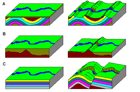
- Erosion in the stream encounters a buried structure, an anticline say, and erodes through it. The structure is later exposed as the overlying material is eroded. This type of stream is called an resequent stream.This is shown in A and B of the figure.
- A stream maintains its course as the rocks are uplifted, eroding through the rocks faster than the rocks are uplifted. This type of stream is called an antecedent stream since it existed before the mountain range. This is shown in C of the figure
The Gaviota Water Gap likely formed as an antecedent stream. The creek's flow established a path to the Pacific Ocean prior to about 5 million years ago. Then the Santa Ynez Fault began uplifting the Santa Ynez Mountains at an average rate of between 1 and 5 millimeters per year by forming an anticline out of the Monterey, Rincon, Vaqueros, Sespe, and some unamed older Formations. The result is several kilometers of uplift in 5 million years; however surface erosion has kept the mountain range to a maximum of about 2,500 feet. Erosion in the creek was faster and cut through the rising rock layers maintaining its channel.
From the vantage of this EarthCache you are likely standing on a ridge of Sespe Formation. Gaviota Creek cuts through a number of layers in the Santa Ynez Mountains flowing from the north to the south. It is one of the few water courses that makes it across the mountain range. Most of Gaviota Creek's 12,877 acres of drainage are north of this ridge. All of the precipitation that falls is focused through this narrow gap allowing the erosion rate to exceed the Santa Ynez Fault's uplift rate.
Logging requirements:
Send me a note with:
- The text "GC59FBX Gaviota Water Gap" on the first line
- The number of people in your group (put in the log as well).
- Given that the elevation in the middle of the Gaviota Water Gap is 262 feet, how many more feet of rock has Gaviota Creek eroded than has been eroded at the coordinates.
- How many thick resistant layers has Gaviota Creek eroded through right at the narrowest part of the Gap?
- Is the erosion rate in the canyon still higher than the surrounding hills? What man-made structures indicate that?
- Optional Extra Hard: What is the differential erosion rate between the point you are standing compared to within the water gap?
The following sources were used to generate this cache:
- Partial Report for Santa Ynez fault zone, Western section (Class A) No. 87b http://gldims.cr.usgs.gov/webapps/cfusion/Sites/qfault/qf_web_disp.cfm?qfault_or=1739&qfault_id=87b
- about.geology.com Water Gap, California http://geology.about.com/od/structureslandforms/ig/erosional/watergap.htm
- Isaacs, Caroline. 1988. Field Trip Guide to Deposition and Diagenisis of the Monterey Formation, Santa Barbara and Santa Maria Areas, California. USGS. Open-File Report 84-88 MacKinnon. Notes on Selected Field Trip Stops. Unknown Date. http://www.agu.org/books/ft/v311/FT311p0052/FT311p0052.pdf
- Gaviota Creek Fish Passage and Geomorphic Assessment. Michael Love and Associates and Stoecker Ecological. March 15, 2007
- Erosion and Landscape Evolution. isearchnotes.com http://isearchnotes.com/single.php?id=279


Find more Earthcaches