
 The trail description and signs say this is a wheelchair accessible trail from the parking area by the headquarters. Even so, it is not paved for much of it and the last bit from the campground to the foot bridge may be the most difficult part.
The rocks in this section of Blooms Creek is Vaqueros Sandstone. This Formation was deposited in a shallow sea during the Oligocene Age, between about 26 to 28 million years ago to about 24 to 25 million years ago..
While this stream appears to have a gentle and rather constant flow. Seasonal storms periodically significantly increase the flow and erosional power of the water resulting in a couple of geomorphologic features characteristic of fluvial (river) environments on bedrock, flutes and potholes.
Flutes –
Flutes are wavy smooth channels ground into the bedrock by fast flowing water. These form by the erosion of the bedrock by the unending grinding of suspended, saltating, and rolling particles against the bedrock. As the water flows over the same pathway across the bedrock and forms a smooth channel. Overtime, the surface of the bedrock becomes polished and smooth.
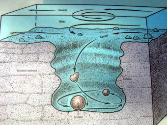 Potholes –
Potholes form where a rock (or many rocks) is spun around in the same spot by circular eddy of water. The constant abrasion begins to wear away the bedrock into a hole. Once started, the feature is self-reinforcing as the hole creates an even stronger eddy. The rock being spun in the hole is called a grinder and as one grinder wears away another rolls in to fill its place.
For those interested in getting a close look at the features there is river access at near 37.16750833 -122.22090833 and another set of potholes in Opal Creek at 37.17184167, -122.22380000
Logging questions:
- The text "GC59H3Y Big Basin Flutes and Potholes" on the first line
- The number of people in your group.
- How many potholes greater than 3 feet across are found here?
- Of the two ways potholes are formed that are listed above, how do you think the potholes are formed?
- Where are the flutes found? How wide are they? Where is the water flow in relation to the flutes?
The above information was compiled from the following sources:
- Jennifer Mikolajczyk , University of Wisconsin
at Eau Claire, Interstate Park, http://www.uwec.edu/jolhm/Interstate2006/potholes.htm
- http://libwiki.mcmaster.ca/clip/index.php/Main/FORMATION
- Thomas Juon and Dak Helentjaris, Last modified May 17, 1999, http://gemini.oscs.montana.edu/~geol445/hyperglac/eroproc1/
- Geology of the Big Basin Area Santa Cruz Mountains, California. Earl Brabb Dissertation. 1960.