The 'A Bridge Too Far' Earthcache is to inform you about natural bridges and the geological process which can create them. This, La Pont de la Moie, is one of the more impressive natural bridges in Jersey. The granite of Jersey is well known for its hard wearing qualities, but that doesn't stop it being broken down by the forces of nature, given enough time, as is demonstrated by this site. As it is an Earthcache there is no container to find but the trip will be a memorable adventure. How you get there is your choice.
To claim this Earthcache find please visit the bridge and complete the three tasks below and send the details to us. By 'visit' we mean that at least one person needs to have stood on the bridge for each Find. Additionally you may wish to upload a photo of an item or you on the bridge.
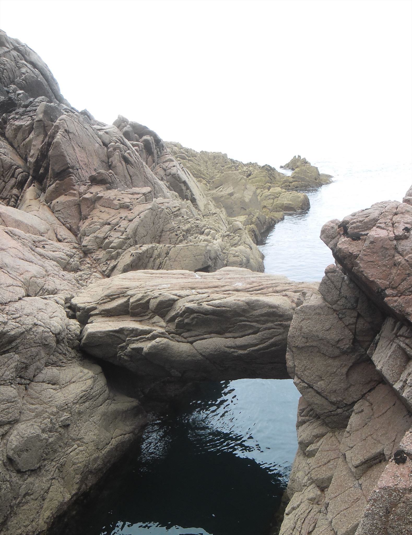
- Looking at the top of the boulder, there is a seam of a darker coloured stone that runs NW-SE through the boulder, approximately how wide is it?
- Some of the geological processes described below will have also created the gulley that the bridge crosses, please explain how this gap may have been formed.
- Looking at the granite, its fault structure and the surrounding headlands, describe where the boulder was likely to have come from.
To send your answers please click on our username at the top of the page and then on Send Message. Please wait for confirmation of your answers before logging a 'Found it'.
Natural bridges can be formed by a number of means; erosion, rockfall, glacial erratics, volcanic bombs and wave action. Apart from erosion all involve a boulder or large stone being repositioned and ending up spanning a gap.
Erosion - airborne material, the sea or running water can slowly wear away or dissolve stone to create a cave. If further erosion then causes part of the cave roof to collapse then the front portion can remain as an arch. The erosion will be quicker and more evident where there is a weakness in the rock or where the abrasion is concentrated, e.g. where the water movement is greatest.
Rockfall - the likely event that formed this natural bridge. Rock falls can be triggered by erosion, freeze/thaw action or earth movement. Freeze/thaw is the cyclic process of water finding its way into faults which then expands as it freezes gradually widening the cracks until the rocks break. Earth movement can be rapid as in earthquakes or land slides, or long term as with tectonic drift which is the gradual movement of the Earth's crust. Faults can occur during the cooling of the rock when it is first formed. Sometimes these faults remain closed and are the weak points that cause the eventual failure or other times they are forced apart and a seam of different material fills the void.
Glacial Erratics - as glaciers progress downwards they pick up material from the surrounding landscape. When the ice eventually melts, boulders released by it can end up deposited many miles from their original location. Erratics are commonly identifiable by being of a different rock type to the underlying rock.
Volcanic bombs - perhaps the most exciting mechanism, volcanic eruptions, as well as releasing lava and ejecting smoke and ash, can throw boulders great distances.
Wave action - large waves cause by storms or occasionally by tsunamis can and do move boulders as well as must smaller rocks, stones and sand. It is the seas movement which gives many shoreline boulders their characteristic rounded appearance.
The position of this boulder is notable because it has ended up lengthways across the top of a wide gap and its upper surface is remarkably level. It may well be a combination of the above as after falling it could well have been affected by erosion and/or wave action.
Also evident are the many faults in this boulder and the surrounding rock which allowed it to break free in the first place.
Kayaking or scrambling down the headland are the easiest ways to reach this cache but both are done at your own risk.
Do not attempt to kayak here unless you are competent as the tides, waves and rocks can be lethal.
If approaching by land then go through the castle and down the path to the navigational lamp. Then go East down the steep slope before heading North onto the rocks. The risk exposure is high as there are tricky slopes and sheer drops, be careful.