Changing the Landscape EarthCache
-
Difficulty:
-

-
Terrain:
-

Size:  (other)
Please note Use of geocaching.com services is subject to the terms and conditions
in our disclaimer.
Significant changes to any landscape usually happen slowly over long periods of time.
But, sometimes, such as with earthquakes or volcanic eruptions, the changes occur quickly.
This earthcache will visit another way that river landscapes may change over relatively short periods of time.
Changing The Landscape - One Dam at a Time
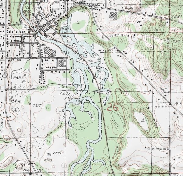
The image to the right is a USGS topographical map of the Middleville Dam and impoundment.
Areas in blue are permanently inundated. Dashed areas are underwater during regular high water events. Green represents forested areas.
When the dam was built on the Thornapple River in the early 1900's, it's primary purpose was to generate electrical power. A secondary purpose was to hold back floodwaters to minimize flood damage downstream.
The problem
The problem with this dam (and ALL dams, in fact) is a process called "siltification".
Silt is a natural phenomenon. It consists of fine grains of sand, primarily quartz and feldspar. Because the grains are so small and have such a large surface-to-volume ratio, they are easily carried by the river currents. These grains are typically carried by the river currents until the water reaches a large, current-free body of water. In the case of the Thornapple River, this is Lake Michigan, by way of the Grand River.
As the water flows into Lake Michigan, the current slows enough that the silt can no longer be carried and it settles on the bottom of the lake. Eventually, much of this silt will wash ashore, becoming the sand that makes up Lake Michigan's prize beaches.
When an obstruction (of any size) impedes the flow of the river, silt will settle in the hollow upstream of the obstruction, until the hollow is filled. Then, when the current is no longer blocked, the silt will continue downstream normally.
In the case of a dam, which is usually built in a river valley with significant elevation changes (and, therefore, fast currents), the silt builds up on the upstream side of the dam. Eventually, the entire impoundment fills in, making the dam useless for it's secondary purpose of flood control.
Since the elevation change at the dam is still there, electric current may still be generated, but efficiency suffers. This is because the operators cannot release extra water to temporarily increase power production in order to meet unexpected demand. The power that can be generated is limited by the actual flow of the river.
Mitigation
There are some techniques to reduce the amount of siltification. One is to have the dam release its water from the bottom, rather than having it flow over the top. This will almost eliminate siltification in the main channel of the river. It does not, however prevent it in the areas of the impoundment that have no current. As you can see from the map, the main channel occupies a very small portion of the total area.
Another technique is called "pulse flow". The operators simply open the floodgates in the dam wide and allow a significant amount of water behind the dam to drain out. This will indeed release a great deal of sediment - at the cost of flooding areas downstream. If those areas contain houses or other structures, they will be flooded. For this reason, pulse flow is only used on rivers that have no areas downstream that will be damaged by the flooding.
Yet another technique is to stop the silt from entering the river in the first place. Erosion control projects have proved to be the most successful in reducing siltification.
Deliberate Siltification
Some countries, particularly in Southeast Asia and Africa, will deliberately build small dams whose sole purpose is to create arable farmland from broken terrain. For example, by 2010 the Bangladeshi government had created over 27,000 hectares of fertile land, which supports over 20,000 families.
The eventual Result
Sooner or later, all dam impoundments will completely fill with silt, making them useless as drinking water reservoirs, flood control, and efficient power generation. When the dam is finally decomissioned, the impoundment will drain and dry out, leaving the deposit of silt behind - permanently changing the landscape.
Logging Requirements
To log this earthcache, go the posted coordinates which is in the Lions Sesquicentennial Park, next to the dam, and answer the following questions:
1. How high is the dam, relative to the river downstream?
2. Is this a top-draw or bottom-draw dam?
3. Assuming your answer for #2, what level of siltification do you think is occurring? (high, medium, or low)
Now, walk along the Paul Henry Trail to the coordinates marked "First Bridge" and answer the following questions:
4. How much siltification has already occurred in the area to the East of the river? (on your left as you walk toward the bridge)
5. How did the silt get there, considering that the main channel does not flow through the area?
6. What do you think will eventually happen to this area if the dam remains in place?
Aside: You can actually measure the siltification using a long pole and a boat. Just push the pole down until it stops. Silt is very soft when wet and the pole will easily travel down until the base gravel or sand of the impoundment is reached. If you do this, I would be very interested to hear your results.
To receive credit for your answers (and be able to log this earthcache as found) please send me an e-mail using my profile link which contains your answers to the questions.
Do not post your answers in your log. Pictures with your log, on the other hand, are always welcome!
Additional Hints
(No hints available.)