EarthCache Create By

Once upon a time a lake ... in Florence (English version)
1.5 million years ago, in the plain where now there are the urban areas of the city of Florence, Prato and Pistoia, an ancient lake occupied this intermontane basin. It was 45 km long, 10 km wide. Everything you are watching from the balustrade of Piazzale Michelangelo is the result of a complex sequence of geological events that occurred over tens of millions of years and which led to the formation of the mountains that you see in front of you and of this plain in which Arno river currently flows.
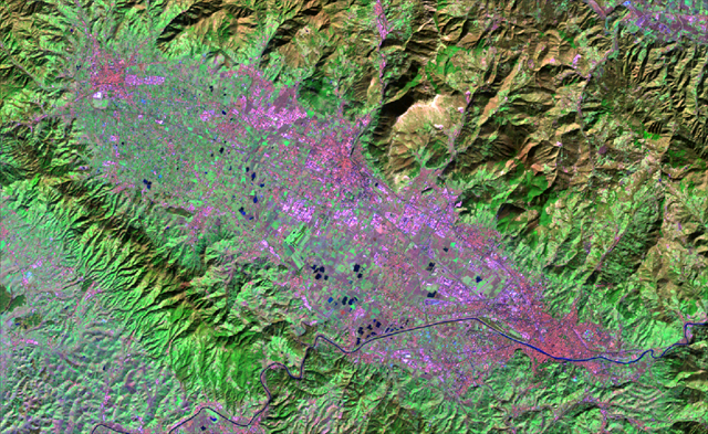
Infrared image of the Landsat Satellite returned false color shows you the shape and location. Now let's retrace the last frames of the geological history.
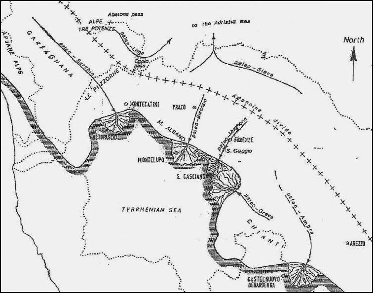
The figure draws Tuscany during Pliocene (2.6 to 5.3 Ma) as the geologists imagine on the basis of the sediments and the shape of the land, with its ancient rivers and with the sea that invaded up to Altopascio, Montelupo and San Casciano. What you see now did not exist then!. The entire area underwent a significant regional rise that was not uniform, certain areas became mountains, some other plains, others sank and were submerged by the waters.
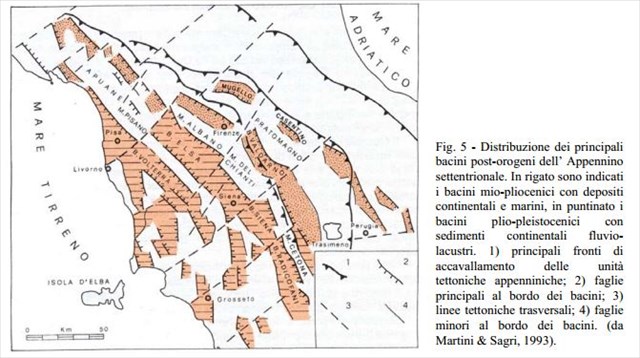
Rift valleys (Graben) and mountain ridges (Horst) were formed, oriented mostly in Apennine direction (NW-SE) and bounded by fracture systems (Faults). At this stage the valleys of the Mugello, the upper Valdarno, Casentino and Siena basin were formed. Since the early Villafranchian the tectonic depression of Florence, Prato, Pistoia becomes a big lake. The weather was cold and over the bottom of the lake Turchine clays started to deposit (clays, more or less sandy and local levels lignite/peat and sand/gravel). 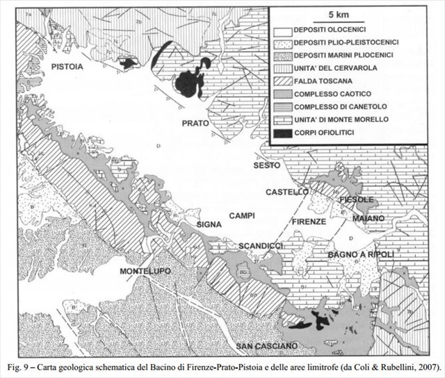
It's clear that the northern edge of the basin is related to a master normal fault that extend from Pistoia to Fiesole Maiano which rises the mountains on your right about 1000 meters above the bottom of the lake, which reaches its maximum depth of 600 meters in the areas of Calenzano. Other faults in perpendicular direction to the main divide across the basin (faults Castello-Scandicci Majano-Bagno a Ripoli) raising the basemennt of the city of Florence about 50 meters from the rest of the basin.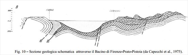
The geological cross section shows an asymmetric profile. So the basin is considered a half graben.
Logging: To log this Earthcache as "Found" you need to do the following: Answer the following questions and send the answers by e-mail to PikeLeo:
1. Why there was a lake? At that time was it the only lake in Tuscany?
2. Why do you think it is emptied?
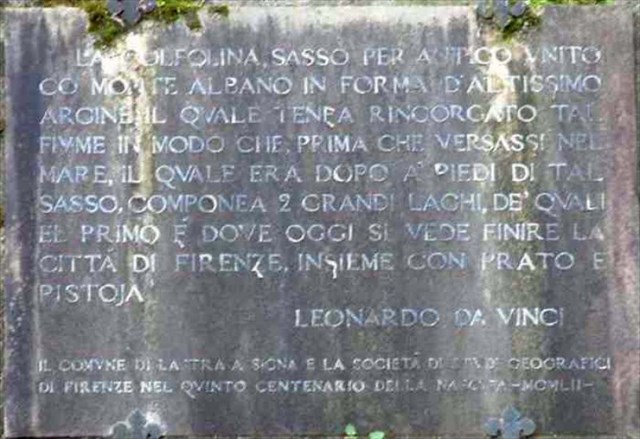
3. Which famous scientist spoke of this lake before any other geologist?
 ?
?
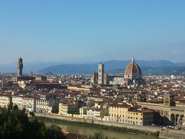
4. Picture above shows, in the background of the Duomo and Giotto's bell tower, the dorsal profile of Calvana Mountains gently sloping to the left. Then the profile ends in the plain. Is there a reason? Is it due to the master fault? YES/NO
Options - Take your photo with the background of Florence.
You do not need to wait for approval of PikeLeo to log the find. If I need more information I'll let you know. Remember not to write the answers on the log !!! Mail to PikeLeo
C'era una volta un lago ... a Firenze (Italiano)
1,5 milioni di anni fa nella pianura dove oggi si sviluppano gran parte delle aree urbane di Firenze, Prato e Pistoia un antico lago occupò questa conca intermontana. Lungo 45 km, largo 10 km. Tutto ciò che state ammirando dalla balaustra del Piazzale Michelangelo è il frutto di un complesso succedersi di eventi geologici occorsi nell'arco di decine di milioni di anni e che hanno portato alla formazione delle montagne che vedete davanti a voi e di questa pianura dove attualmente scorre il fiume Arno.
L' immagine ad infrarossi del Satellite Landsat restituita in falsi colori la rappresenta molto bene evidenziandone forma e collocazione. Ripercorriamo ora gli ultimi fotogrammi della storia geologica.
In figura è disegnata la Toscana pliocenica (2,6-5,3 Ma) come se la immaginano i geologi sulla base dei sedimenti e della conformazione del terreno, con i suoi antichi fiumi e con il mare che la invadeva fino ad Altopascio, Montelupo e San Casciano. Quello che vedete ora quindi non esisteva!. Tutto il territorio subì un innalzamento regionale notevole ma non omogeneo, alcune zone diventarono montagne, alcune rimasero pianure, altre sprofondarono e furono sommerse dalle acque.
Si formarono fosse tettoniche (Graben) e dorsali montuose (Horst), orientate per lo più in direzione appenninica (NO-SE) e delimitate da sistemi di fratture (Faglie).
In questa fase si formano anche i bacini e le valli del Mugello, Valdarno superiore, Val di Pesa, Casentino e Siena. E' dal Villafranchiano inferiore che la depressione tettonica di Firenze Prato Pistoia diventa un grande lago. Il clima è freddo e sul fondo del lago si depositano le Argille Turchine (argille più o meno sabbiose con locali livelli di lignite/torba e sabbia/ghiaia).
E' evidente che il bordo settentrionale del bacino sia legato ad un importante faglia di tipo normale tracciabile da Pistoia a Fiesole Maiano che innalza le montagne sulla vostra destra di circa 1000 metri rispetto al fondo del lago che raggiunge la sua massima profondità di 600 metri sotto le aree di Prato Calenzano. Altre faglie con direzione perpendicolare alla principale suddividono trasversalmente il bacino (faglie Castello-Scandicci e Maiano-Bagno a Ripoli) rialzando il blocco di Firenze di circa 50 metri rispetto al resto del bacino.
La sezione geologica trasversale mostra un profilo asimmetrico. E' considerato un semi graben.
Come loggare: Per loggare questa Earthcache  come
come  "Trovato" occorre effettuare le seguenti operazioni: Rispondete alle seguenti domande e mandate le risposte via e-mail a PikeLeo:
1. Perchè si è formato il lago? E' l'unico lago toscano ad essersi formato in quel periodo?
2. Per quali motivi pensi si sia svuotato?
3. Quale famoso scienziato ha parlato di questo lago prima di qualsiasi altro geologo?
?
4. Nella foto soprastante è mostrato sullo sfondo del Duomo e del Campanile di Giotto il profilo della dorsale dei Monti della Calvana dolcemente inclinato verso sinistra che finisce nella pianura. Per quale ragione la dorsale non poteva proseguire oltre, verso ovest? A causa della faglia principale del lago? SI/NO
Optional – Fate una vostra foto con lo sfondo di Firenze.
Non è necessario attendere l’approvazione di PikeLeo per loggare il ritrovamento. Se avrò bisogno di ulteriori informazioni ve lo farò sapere. Ricordate di non scrivere le risposte sul log !!! Mail a: PikeLeo