Questions to answer
Please email the CO with these answers- do not include in your log.
Location 1:
(a) Look to the North and describe how much water is in this location. What floodplain role do you surmise this portion represents?
(b) Looking to the south, describe the amount of water in this section. Share what floodplain role you believe this area plays.
Location 2:
(a) Looking to the east, describe the features you see that assist in managing the flow of water back into the creek.
Description
Many geocachers are not fond of rain when seeking caches. Have you ever wondered where the water goes? Generally speaking, the region that the rain hits (after getting you wet) is called a watershed; that is, an “area of land drained by creeks, streams, and/or rivers. Like a giant bowl, land in a watershed gathers water that flows downward. This includes land that catches rainfall.” There are many watersheds in the state of Michigan.
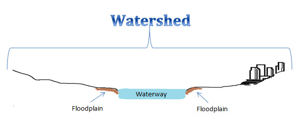
In most cases, water travels these routes without incident or special note. However, sometimes the quantity of water outstrips the ability of the land to utilize its normal pathways- we call these events floods. The natural terrains where these events occur are called floodplains: usually “flat areas along creeks, streams, and rivers that are covered in water during floods and help to lessen the damage caused by flooding.”
Floodplains
Floodplains serve a number of important purposes:
- Reduce water velocity. When water slows down, it lowers the amount of erosion that occurs, and allows existing sediment to settle to the bottom
- Improve water quality. With the reduction in sediment and the opportunity for other items carried by water to be “left behind”, the water that continues its journey can be lower in phosphorous content and other items fast moving water may have carried along (trash, tree branches, etc.)
- Control temperature. It can take time for water to traverse a floodplain, allowing time for the water to be more consistent with ground temperature. This prevents environmental stressors to fish, reptiles, and plants residing in the waterway
- Provide fish and other wildlife habitat for breeding and feeding
Site and History
This site represents a human-made floodplain. It mimics the effects of a floodplain as part of a strategy to mitigate erosion due to flooding, reduce sediment runoff into Mallet’s Creek, and capture phosphorous and other water impurities before being transported down to the Huron River.
This site was originally a pond, designed as part of a larger storm water control plan in the 1970s. Over time, the pond filled with sediment, lessening its effectiveness. In 1999, plans for a complete redesign of the area began. Goals included slowing down water runoff, capture of silt and other water impurities, reducing e coli and mosquito breeding locations, providing time for some of the water to be absorbed by the ground and fauna, and creating a wetlands area. The site, dedicated in 2008, provides nice delineations of different parts of a flood plain and how water is managed.
Sources
Quoted definitions taken from http://focusonfloods.org/
FEMA
Michigan Association of County Drain Commissioners
Ann Arbor Parks and Recreation
Congrats C and Z's LOOT, FTF
Additional Navigational Assistance
Park Map