|


De forma alongada, elíptica, orientada na direcção este-oeste, a serra de Sintra mede apenas 10 km de comprimento por 5 km na maior largura. É, a ocidente de Lisboa, o acidente geomorfológico mais destacado existente nesta área que constitui recanto maravilhoso, não só pela beleza da paisagem, doçura e amenidade do ambiente, como pela complexidade geológica da estrutura do arcaboiço que a forma, assim como pela variedade da vegetação que a cobre.
O encaixe do Maciço de Sintra na plataforma carbonatada na zona do Guincho veio criar uma estrutura sinclinal cujo eixo corre mais ou menos numa direcção E-W a meio da Praia do Guincho. Isto implica que os estratos de rocha a norte deste eixo inclinem para sul enquanto que os que afloram a sul deste eixo inclinem para norte.

The Sintra Mountain, located 30 km west of the Lisbon city centre, is 10 km long and 5 km wide. In the west the mountain is truncated by 150 m-high sheer cliffs at Cabo the Roca. The maximum height above mean sea level is 528 m at Cruz Alta.
The slotting of the Sintra Massif on the carbonate platform in the Guincho area has led to the formation of a synclinal structure whose axis runs more or less in E-W in the middle of the Guincho Beach. This implies that the rock strata north of this axis tilt south while those that outcrop south of that axis are tilted to the north.
Geological setting / Enquadramento geológico
The rock types are reef limestones of Lower Cretaceous (Hauterivian – Barremian; 136.4 to 125 M.a.) age striking E-W and dipping gently to the N cut occasionally by igneous dykes.
No ponto zero estarão em cima de calcários recifais do Cretácico Inferior por vezes cortados por diques de rocha ígnea.
Claiming the Earthcache / Para logares esta EC
At the coordinates you will see a sequence of alternating strata of pure to marly limestones and your task is to: 1- accurately determine dip and strike at this location using the instructions set out on the cache page and 2- measure the thickness of the strata.
Send me the answers through my geocaching profile to validate your found.
No local das coordenadas estás perante uma sequência alternada de rochas carbonatadas e as tuas tarefas são: 1- medir a direcção e pendor dessas camadas e 2- medir a espessura das camadas expostas.
Envia as tuas respostas para validares o teu found via o meu perfil do geocaching.com.
What is stratigraphy?
Stratigraphy is basically the study of rock layers and layering (stratification). It is primarily used in the study of sedimentary and layered volcanic rocks. The subject was essentially invented and first rigorously applied by William Smith in England in the 1790s and early 1800s.
Stratigraphy includes two related subfields: lithologic or lithostratigraphy and biologic stratigraphy or biostratigraphy. Lithostratigraphy, or lithologic stratigraphy, is the most obvious. It deals with the physical lithological or rock type change both vertically in layering or bedding of varying rock type and laterally reflecting changing environments of deposition, known as facies change. Key elements of stratigraphy involve understanding how certain geometric relationships between rock layers arise and what these geometries mean in terms of depositional environment. One of stratigraphy's basic concepts is codified in the Law of Superposition, which simply states that, in an undeformed stratigraphic sequence, the oldest strata occur at the base of the sequence.
Measuring stratigraphy
· One way to think of the strike is it represents the compass direction (azimuth) of the trace of a layer across the surface of the Earth, if the surface is approximately horizontal. This means a measurement of the strike will tell you the direction a layer should appear on a geological map.
· The dip is the angle of inclination of the layer with respect to the surface. This angle is measured perpendicular to the strike.
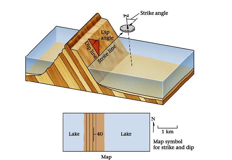
Measuring strike:
We will begin by taking the strike of a bedding plane. For these measurements we will use a compass. In order to measure the strike, place the side or edge of the compass against the plane of the outcrop. Sometimes it is easier to put your field book against the outcrop and then the compass against the book to get a smoother and/or a larger surface. Now, rotate the compass keeping the lower side edge of the compass fixed, until the bulls-eye level bubble is centered (the round tube; not the long narrow one). When the bubble is centered, the compass is horizontal against the plane and parallel to the line of strike. Now, with the bulls-eye bubble centered, record the number that either end of the compass needle is showing.
In other words:
- Place the bottom EDGE of the compass flat against the plane of interest.
- Adjust the compass orientation, making sure the bottom edge is always flat against the plane, until the air bubble in the "Bull's eye level" is centered.
- Read either end of the compass needle to obtain the value of strike.
Measuring Dip:
To measure the dip of the bedding plane, take your compass and put its side against the rock so that it points in the same direction as the line of dip (The dip line is perpendicular to the strike line). Move the clinometer until the clinometer level bubble is centered. As we did when we found the strike, record where the white tipped end of the clinometer needle is pointing. Note the degrees and the direction. Recall that the dip direction MUST always be perpendicular to the strike direction (e.g., a strike of 40° could only dip to the SE or NW, never NE or SW)
In other words:
- AFTER you determine strike, rotate the compass 90°.
- Place the SIDE of the compass flat against the plane.
- Adjust the lever on the back of the compass until the air bubble in the "Clinometer level" is centred.
- Read the dip directly from the scale in the compass.
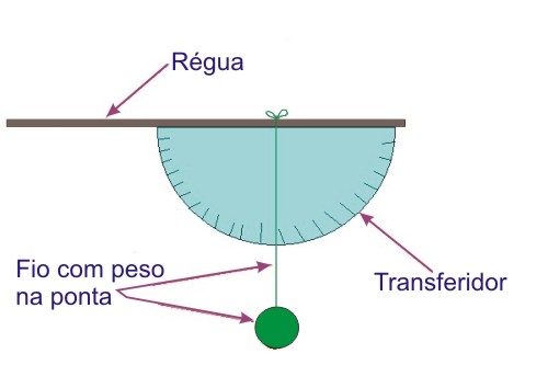
You will need a compass (I will accept a simple N, S, E or W or any variation in between) a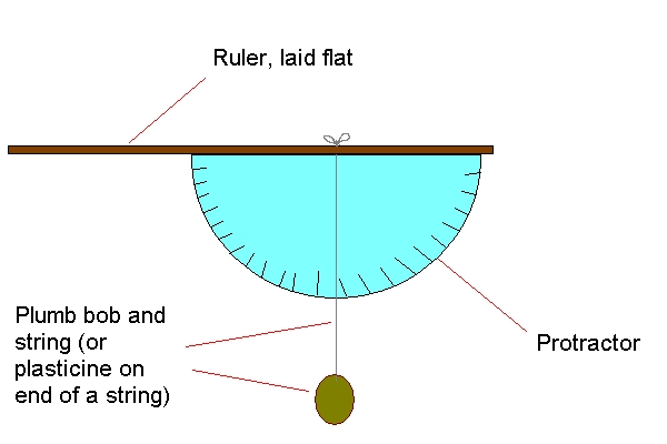 nd a clinometer. There is no need to get a fancy instrument. A simple clinometer can be fashioned using a plastic protractor and a string with a weight attached or if you have a smartphone, there is a simple free application called "clinometer" that you can use. nd a clinometer. There is no need to get a fancy instrument. A simple clinometer can be fashioned using a plastic protractor and a string with a weight attached or if you have a smartphone, there is a simple free application called "clinometer" that you can use.
Estratigrafia. O que é?
A Estratigrafia é o ramo da Geologia que estuda as seqüências de camadas de rochas, buscando de terminar os processos e eventos que as formaram. A estratigrafia inclui dois subcampos, a litoestratigrafia e bioestratigrafia.  A primeira se baseia na análise das propriedades físicas e químicas das rochas; a segunda, no estudo das evidências fósseis gravadas nas rochas. A partir das descobertas nessas duas áreas, criou-se uma escala de tempo geológico, que serve de referencial temporal não só à Geologia como também à Paleontologia. A estratigrafia, que vem do latim stratum + grego graphia, é a descrição de todos os corpos rochosos que formam a crosta da Terra e sua organização em unidades mapeáveis distintas e úteis, com base em suas propriedades ou atributos intrínsecos, com vistas a estabelecer sua distribuição e relações no espaço e sua sucessão no tempo, e para interpretar a história geológica. A primeira se baseia na análise das propriedades físicas e químicas das rochas; a segunda, no estudo das evidências fósseis gravadas nas rochas. A partir das descobertas nessas duas áreas, criou-se uma escala de tempo geológico, que serve de referencial temporal não só à Geologia como também à Paleontologia. A estratigrafia, que vem do latim stratum + grego graphia, é a descrição de todos os corpos rochosos que formam a crosta da Terra e sua organização em unidades mapeáveis distintas e úteis, com base em suas propriedades ou atributos intrínsecos, com vistas a estabelecer sua distribuição e relações no espaço e sua sucessão no tempo, e para interpretar a história geológica.
Medindo a estratigrafia
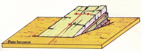
As camadas de rocha são caracterizadas medindo a sua direcção e pendor ou inclinação. A direcção de uma camada é a sua medida no plano horizontal ou a direcção da linha de intersecção da estratificação com o plano horizontal (d).
O pendor ou inclinação de uma camada é o ângulo entre a estratificação e o plano horizontal (i) e é medido no plano vertical perpendicular aos dois planos referidos.
A direcção e o pendor de uma camada constituem as suas coordenadas geológicas, referindo-se sempre em primeiro lugar a direcção e depois a inclinação (ex. N30º E, 40 S).
Para realizar estas tarefas vais necessitar de uma bússola e um clinómetro. Um clinómetro simples pode ser feito usando um transferidor com um pouco de fio e um peso. Ou então se tiveres um smartphone, podes instalar uma aplicação gratuita chamada "clinometer".
|