Localización
El estuario del río Miño se extiende a lo largo de 14 kilómetros, para alcanzar los dos mil metros de ancho en su desembocadura, en A Guarda. Su margen final está ocupada por un larguísimo arenal en el que se han formado tres playas fluviales de fina arena, cuyas aguas cambian de grado de salinidad a medida que lo hacen las mareas. Así, cuando está en baja el agua se presenta dulce y casi templada, mientras que en pleamar, cuando el Atlántico penetra con fuerza en la desembocadura, la temperatura del agua desciende y sube su salinidad.
Todo el estuario posee una excepcional riqueza ornitológica. Cormoranes, garzas reales o gacelas conviven aquí con correlimos, porrones moñudos, ánades reales, avefrías, martines pescadores y un largo etcétera. También las riberas del Miño y sus aguas son refugio de varias especies tanto vegetales como piscícolas. Salmones, que tienen aquí su limite de distribución más meridional de toda Europa, lampreas o anguilas nadan a la sombra de un espeso bosque de ribera
El Monte de Santa Tecla constituye un mirador fantastico sobre el Estuario, permitiendo comtemplarlo en toda su extensión

-En geografía, un estuario es la desembocadura en el mar, de un río amplio y profundo, e intercambia con esta agua salada y agua dulce, debido a las mareas. La desembocadura del estuario está formada por un solo brazo ancho en forma de embudo ensanchado. Suele tener playas a ambos lados, en las que la retirada de las aguas permite el crecimiento de algunas especies vegetales que soportan aguas salinas. En resumen, es el accidente geográfico que se genera cuando el agua dulce se mezcla con el agua salada.
-Los estuarios se originan por la entrada de aguas marinas durante la pleamar, retiene las aguas del río, mientras que durante la bajamar, todas las aguas comienzan a entrar a gran velocidad en el mar u océano, lo que contribuye a limpiar y profundizar su cauce, dejando a menudo, grandes zonas de marismas.
La simultaneidad y variabilidad temporal de los agentes naturales y la diversidad de las acciones humanas producen una amplia gama de regímenes hídricos del estuario, en un extremo aquellos relacionados con la escasez de recurso agua dulce y en el otro los provocados por las avenidas del río y los temporales en la desembocadura
-Cuando el caudal de agua dulce del río es bajo, la dinámica del estuario está dominada por la acción mareal y se denomina régimen de caudales bajos.
-En el régimen de dominio fluvial (se corresponde con la presencia de grandes avenidas), la dinámica fluvial controla la circulación de agua y sustancias en el estuario, la erosión del cauce y los procesos asociados a la marea, salinidad y turbidez, se subordinan a aquella.
-Entre ellos dos se reconoce el régimen mixto fluvial-mareal en el que la dinámica del estuario transita, sin discontinuidad, entre aquellos dos regímenes.
Clasificación morfológica
Existen dos tipos de estuarios, los dominados por la energía de las olas, y los dominados por las mareas.
a) Estuarios dominados por oleaje: En éstos, las olas tienen un efecto importante en la boca, donde el sedimento erosionado de la línea de costa es transportado a lo largo de la playa formando una barra. Ésta estrecha la boca, y se formará hasta que las corrientes de marea, que aumentan gradualmente con la disminución de la sección transversal, lleguen a un equilibrio de modo que la erosión del sedimento de la punta de la barra sea tan rápida como lo es su depósito allí debido a la deriva litoral
b) Estuarios dominados por la marea: Se forman como resultado de corrientes de marea importantes respecto al efecto del oleaje. La boca generalmente tiene bancos de arena que son alineados con el flujo de la corriente y alrededor de los cuales circula el sedimento. En la cabeza del estuario la influencia de la marea disminuye y el flujo de río se vuelve dominante.
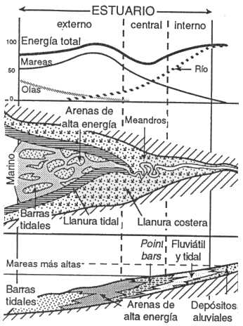
Los dos tipos de estuarios presentados son dos extremos, entre los cuales pueden ocurrir muchas variaciones en función de factores sedimentarios o morfológicos.
-Influencia mixta de olas y mareas.- En un estuario dominado por las olas, si crece la energía de las mareas, pasos de marea cortaran la barrera y la arena redistribuida edificará progresivamente barras tidales alargadas. En la parte central, el ingreso de las corrientes tidales hace crecer la energía. Se forman canales de marea, y se depositan arenas de origen marino. Las orillas del lagoon están cubiertas por depósitos de llanura tidal. En el fondo, el delta, anteriormente dominado por el río, se transforma en delta dominado por la mareas.
-Influencia de los aportes sedimentarios.- Si los aportes sedimentarios fluviátiles son importantes, el delta de desembocadura prograda y rellena rápidamente el estuario. De la misma manera el tamaño del cuerpo marino depende del aporte de sedimentos procedentes del mar.
-Morfología y tamaño del estuario.- Si el valle es sinuoso, la fricción frena las corrientes de marea y disminuye su energía, favoreciendo la edificación por las olas de una barrera. El gradiente costero (pendiente) y la amplitud de las mareas controlan la longitud del sistema estuarino. También el caudal respectivo de las mareas y del río controlan el tamaño de las zonas dominadas por dichos procesos.
- Relleno del estuario.- En un estuario dominado por las olas, la progradación del delta del fondo de la bahía y del delta tidal rellenan la parte central, donde el canal tidal y el canal fluviátil se unen, permitiendo el ingreso más fácil de las corrientes de mareas. En un estuario dominado por corrientes tidales, éstas retrabajan las arenas tanto fluviatiles como marinas, que rellenan rápidamente las partes profundas y anchas, hasta formar la morfología en embudo. Luego, el sistema prograda sin cambio importante de forma. En ambos casos, si sigue la progradación, el estuario relleno es sobreyacido por un delta. La principal diferencia entre estuario y delta es la dirección de transporte del material: bimodal en el primer caso, hacia el mar en el segundo.
Para logar este EarthCache, envíame un correo electrónico con la respuesta a las siguientes preguntas:
1) ¿Cual es el regimen dominante en este estuario? (Dominado por las olas, o por las mareas). Dame una muy breve explicación de tu conclusión
2) ¿Cual es la principal diferencia entre un delta y un estuario?
3) En las coordenadas dadas puedes ver una cruz encima de una roca.Dime la altura de esta roca al suelo , ¿cuantas caras "planas" tiene esta roca?
4) Añade una fotografia tuya en el local, u otra en la que se pueda ver algún objeto, o tu nick en un papel
-Si crees que as concluido con exito los objetivos de este Earth Cache, y me ha enviado todas las respuestas solicitadas, puede hacer el log. Luego yo comprobaré que son correctas, y si hay cualquier problema me pondre en contacto para arreglarlo.
-Logs sin respuestas enviadas previamente, seran borrados sin aviso
English (GoogleTranslate)
Location
The estuary of the "Miño River" extends along 14 kilometers to reach two thousand meters wide at its mouth in A Guarda. His final margin is occupied by a very long sandy area in which are formed three river sandy beaches whose water salinity change as do the tides. Thus, when low water occurs almost sweet and warm, while at high tide, when the Atlantic penetrates hard at the mouth, the water temperature drops and raises its salinity.
Entire estuary has an exceptional ornithological wealth. Cormorants, herons and gazelles live here with sandpipers, tufted ducks, mallards, lapwings, kingfishers and many others. Also the banks of the Miño and its waters are home to several species both plant and fish. Salmon, which have here their southernmost limit of distribution across Europe, lampreys or eels swimming in the shade of a thick riparian forest
Monte de Santa Tecla is a fantastic viewpoint over the estuary, I allowing contemplate it in its entirety
-In geography, an estuary is the mouth at the sea, a broad and deep river, and exchanges with the salt water and fresh water due to tides. The mouth of the estuary is formed by one arm width widened funnel. Usually it has beaches on both sides, where the removal of water allows the growth of some plant species that support saline waters. In short, it is the landform that is generated when the fresh water mixes with salt water.
-The Estuaries are caused by the entrance of seawater at high tide, retains the river, while at low tide, all the waters begin to enter at high speed in the sea or ocean, which contributes to clean and deepen their channel, often leaving, large areas of marsh.
Simultaneity and temporal variability of natural agents and the diversity of human actions produce a wide range of water regimes estuary at one end those related to the scarcity of fresh water resources and on the other those caused by river floods and storms in the mouth
When the freshwater flow of the river is low, the dynamics of the estuary is dominated by tidal action and is called low flow regime.
-In the "regime fluvial" domain (corresponds to the presence of large avenues), fluvial dynamics controls the flow of water and substances in the estuary, channel erosion and the processes associated with the tide, salinity and turbidity, they are subordinated to that.
Including two river-tidal mixed system in which the dynamics of the estuary passes without interruption between these two regimes is recognized.
Morphological classification
There are two types of estuaries, dominated by the energy of the waves, and dominated by the tides.
a) Estuaries dominated by waves: In these, the waves have an important effect in the mouth, where the sediment eroded from the coastline is transported along the beach forming a bar. This narrows the mouth, and will form until tidal currents, which gradually increase with decreasing cross section, to reach equilibrium so that erosion sediment rod tip is as rapid as is its deposit there because longshore drift
b) Dominated by the tidal estuaries: They are formed as a result of tidal currents important for the effect of waves. Mouth usually has sandbars are aligned with the flow stream and around which circulates the sediment. At the head of the estuary the tidal influence decreases and the river flow becomes dominant.
The two types are presented estuarine two ends, of which many variations may occur depending on sedimentary or morphological factors.
-Mixed influence of wave and tidal. - In estuarydominated by the waves, if growing tidal energy, tidal steps cut the barrier and the sand redistributed progressively build tidal elongated bars. In the central part, the income of tidal current energy grows. tidal channels are formed, and sands of marine origin are deposited. The banks of the lagoon are covered by deposits of tidal plain. In the background, the Delta, previously dominated by the river delta becomes dominated by the tides.
-Influence of sedimentary contributions.- If fluvial sedimentary contributions are important, the delta of prograde mouth and quickly filled the estuary. In the same way the size of the body depends on marine sediment from the sea.
-Morphology and size of the estuary.- If the valley is winding, the friction brakes tidal currents and lowers their energy, promoting the building by the waves of a barrier. The coastal gradient (slope) and the amplitude of the tides control the length of the estuarine system. Also the respective flow of the tides and river control the size of the areas dominated by such processes.
- Filling the estuary .- In an estuary dominated by the waves, the delta progradation bottom of the bay and the tidal delta fill the central part, where the tidal channel and the channel fluviátil bind, allowing easier entry of the currents tide. In an estuary dominated by tidal currents, they retrabajan fluviatiles both sands and sea, which quickly filled the deep parts and wide, to form the funnel morphology. Then the system prograde without significant change in shape. In both cases, if you follow the progradation, estuary filling is overlain by a delta. The main difference between estuary and delta is the transport direction of the material: bimodal in the first case, to the sea in the second.
To log this earthcache, send me an email with the answer to the following questions:
1) What is the ruling regime in this estuary? (Dominated by waves or tides). Give me a very brief explanation of your conclusion
2) What is the main difference between a delta and estuary ?
3) In the given coordinates you can see a cross on top of a rock.Tell me the height of this rock to the ground. How many "flat" faces does this rock?
4) Add a photo of yourself at the place, or another in which you can see an object, or your nick on a piece of paper
-If you believe you have successfully completed this Earth Cache goals and has alreadysent to me all the requirements as requested, Please, feel free to log it as found. Later i will verify the requirements sent and, if necessary, contact you in order to make the necessary corrections to your log.
-Logs without answers, will be deleted without notice.