The Anthropocene is the current geologic time period--the time where people’s activities have begun to change the way the earth works (http://www.nature.com/news/anthropocene-the-human-age-1.17085).
The site is much more than just this. It is a spectacular combination of geological features, spread over 115 acres of dynamic swamp and marsh south of Calumet. It is underlain by the lavas of the Portage Lake Volcanics(http://www.geo.mtu.edu/KeweenawGeoheritage/BlackLavas/Stratigraphy/Stratigraphy.html), which dip at about 45 degrees to the NW and these have been eroded by glaciation to a flat surface. On top of this surface is a discontinuous cover of glacially-derived moraine and outwash which traps surface water above bedrock in wetlands. There is a slow-moving creek (Boston Creek) which crosses the area from south to north, the main source of surface water. On the NW side of US 41 is Boston Lake, which is the result of artificial damming of Boston Creek and part of the Nature Area as well.
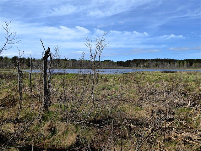
Figure 1: The Paavola Wetlands as seen from the S in May 2015 is marked by a central beaver pond, surrounded by marsh and swamp.
The exact GPS location is a parking spot, which marks the beginning of a walking exploration of this everchanging wetland. To experience the area walk both the universally accessible trail and the rustic footpath (Figure 1). Some key places to visit are the Farmstead (N 47° 09.425 W 88° 32.015), the Pond Overlook (N 47° 09.765 W 88° 31.848) and the Powercut (N 47° 09.469 W 88° 32.203).
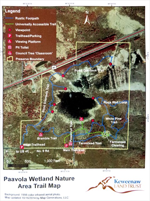
Figure 2: Paavola Wetland Nature Area Map. Keweenaw Land Trust source. An interactive map from Google Maps
Earth Cache Lessons: Minor or subtle changes involving the surface material here affect the wetland markedly. In areas with thin soil and overburden over a bedrock surface that does not have a significant slope, small blockages can back up lots of water. Removal of blockages can cause the water to flow away. Paavola offers a lesson on dynamic wetland changes.
Wetland varieties: Wetlands are classified by the type of soil, vegetation and(or) the source of water supporting the wetland. Wetlands with shallow organic soils over mineral soils with tall emergent herbaceous plants (e.g., cattails, sedges, rushes, grasses) are termed marshes. Wetlands that are densely covered by trees are termed swamps in this country. Wetlands with deep organic soils are termed peatlands, which can be further subdivided into bogs and fens. Bogs are supported solely by precipitation and are generally nutrient poor, while fens are supported by some groundwater and are often more nutrient rich compared to bogs. At Paavola there are areas of marsh, swamp and a pond with submergent and floating vegetation with the proportions of each changing all the time, seasonally and over periods of decades. The unstable changes were caused by human activity in the early 20th Century and by beavers more recently and probably before humans settled here. Both of these wetland modifiers have affected surface water substantially in opposite senses: beavers damming the surface flow and humans trying to drain it, using a ditching procedure called suo ojat in Finland (where the farmers immigrated from).
Unusual Global Change Context: Paavola is an instructive example of Anthropocene (http://en.wikipedia.org/wiki/Anthropocene) impact on an area, where humans have changed the local surface water and vegetation controls by modifying the landscape. Forests were harvested across the Upper Peninsula in the late 19th Century, wetland drainage at Paavola happened some decades following deforestation. Beaver had been trapped extensively and largely removed from the area even before deforestation. All of these anthropogenic changes affected surface water and the occurrence of wetlands. The rate of global change due to worldwide fossil fuel use did not result in the growing seasons lengthening sufficiently to allow profitable farming, however. Finnish immigrant famers did not realize that the copper country, which looks like their native Finland, doesn’t have the longer growing season that the Gulfstream provides in Finland, which was too short for most crops they grew before. So Paavola’s farming history was short and unsustainable. After the farming ended, the beavers and the forests came back, but probably different than what was there previously. The beavers redammed the area and the flooded area grew, and beginning in the 1950s a much larger beaver pond had developed with beaver lodges and an extensive network of more than 20 dams above and below the main pond.
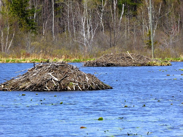
Figure 3: Beaver Lodges in the Paavola pond, May 2015
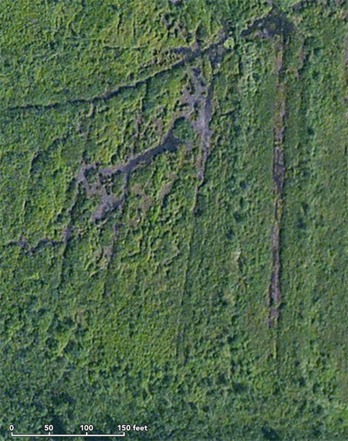
Figure 4: Aerial view of an area north of the beaver pond at Paavola Wetlands, where remnants of ditching to drain the wetlands was done nearly 100 years ago, when Finnish immigrant farmers settled the area. Apple Maps image.
Mining activity: US 41 follows a direction that perfectly parallels the strike direction of the hundreds of lava flow layers that underlie Paavola Wetlands--all of which dip to the NW at 45-60 degrees. North of the wetlands are a line of old mine shafts (St Mary’s, Franklin and Rhode Island) which extracted copper and followed the line of shafts of the Pewabic Amygdaloid at Quincy (http://www.geo.mtu.edu/KeweenawGeoheritage/BlackLavas/Quincy.html), one of two highly productive layers within the whole lava formation. South of Paavola are the Arcadian shafts, which are along the same horizon as the Isle Royale mines, another less important productive horizon within the lavas, mainly south of Houghton. Mining activity near Paavola was mostly over by 1910. None of these mines near Paavola was very successful.
Boston Pond: Boston Lake was created as a tailings pond (where to dump waste rock as part of mining activities) in the mid 1800s. In 1968 the Michigan DNR further engineered damming of Boston Creek north of Paavola Wetlands, enhancing Boston Pond, an area now envisioned for recreational fishing, positioned along an old railroad grade which is now a public recreational trail for snowmobiles and bikes.
Logging your visit:
Send an email to answer the following questions:
What are the wetland types? Describe what you see in each type.
Will the pond get larger? Will swamps grow in area?
What does the future hold for these wetlands? How will the war between ancient (Holocene) environmental controls (beavers are part of this) and man (Anthropocene agent)drive the proportions of various wetlands?
Earth Science Literacy Principles Big Ideas
Big Idea number 5- Earth is the water planet.
Visit http://www.earthscienceliteracy.org/es_literacy_22may09.pdf for more information on the Big Ideas.
Bibliography:
Keweenaw Geoheritage: http://www.geo.mtu.edu/KeweenawGeoheritage
Some other Michigan EarthCache sites for comparison:
http://www.geocaching.com/geocache/GC2CFC6_spring-lakes-wetlands-ec
http://www.geocaching.com/geocache/GC177KF_wetlands-whats-in-a-nam
http://www.geocaching.com/geocache/GC166CM_west-lake-bog
http://www.geocaching.com/geocache/GC1H8B0_peatlands-beaver-pond-swamp?Submit6=Go
http://www.geocaching.com/geocache/GC1H8AX_peatlands-kettlehole-bog?Submit6=Go
http://www.geocaching.com/geocache/GC1ENZG_the-paw-paw-necklace-a-prairie-fen
http://www.geocaching.com/geocache/GC12FRK_huron-clinton-marshlands
Image Permissions:
Figure 1: Map from Keweenaw Land Trust.
Figure 2: Apple Maps Images, public use with attribution permitted.
EarthCache Site Permission:
This site (Paavola Wetlands Nature Area) is managed by the Keweenaw Land Trust and is open for public access including EarthCache explorations envisioned here (see http://www.keweenawlandtrust.org/special-paavola.php).
Contact:
1. Evan McDonald
Keweenaw Land Trust
801 N. Lincoln Dr. Ste. 306
Hancock, MI 49930
906-482-0820