Before glaciation the Merrimack River flowed directly south entering the Atlantic Ocean near Boston. When the Continental Ice Sheet retreated approximately 10,000 years ago, a terminal moraine deposited debris which filled the Valley, and as glacial ice melt accumulated behind the dam, a narrow lake was created. The lake slowly grew as the ice continued to melt and retreat back up the Merrimack River valley. At its maximum, Glacial Lake Merrimack extended from south of Manchester northwards to Plymouth. (Sometime during this process, the debris around the dam redirected the Merrimack River into its current northeast bend at Lowell.)
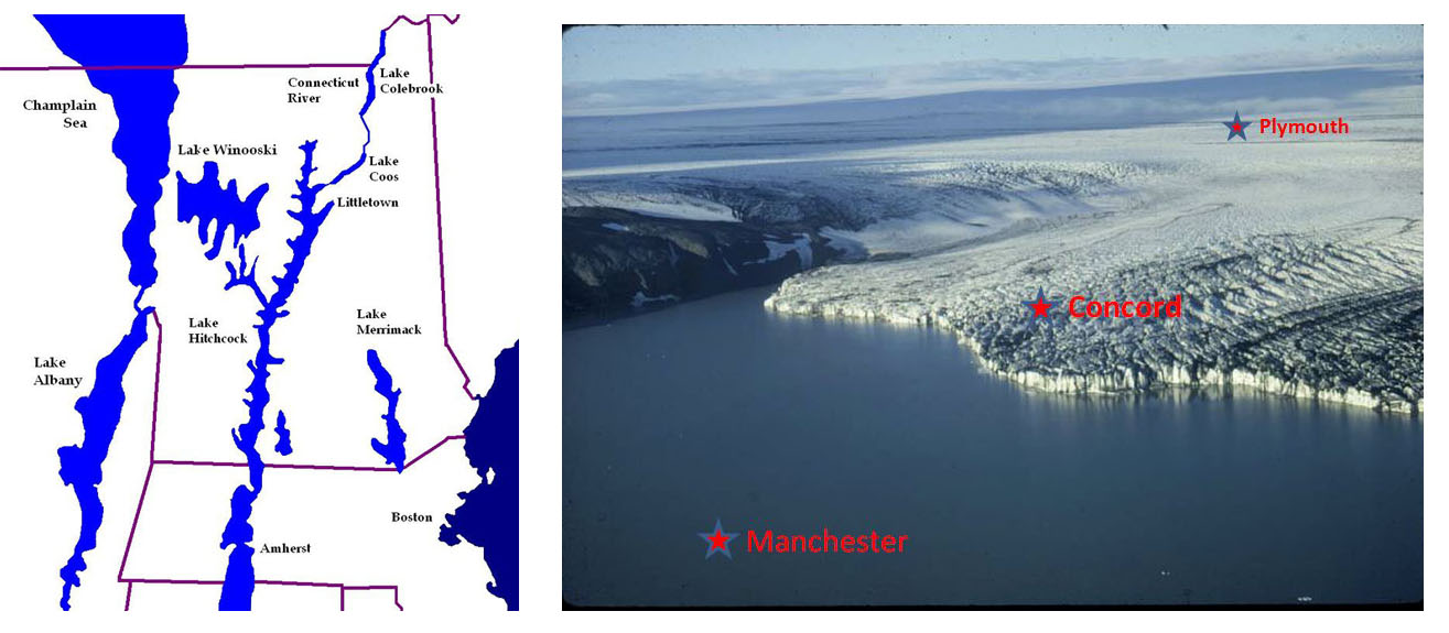
Please note: this is not an actual photograph of Lake Merrimack ;-)
In some glacial lakes, a sudden rupturing of the dam caused catastrophic release of water resulting in the formation of gorges and other downstream structures. From the absence of these structures in the southern Merrimack Valley, we know Lake Merrimack evaporated gradually during the period after the ice age. It is the persistence of the Lake over hundreds of years that led to the formation of the Muchayedo Bluffs.
Erosion and deposition
The mile-high sheet of ice generated tremendous mechanical force, and the scouring action of the glacier pulverized the underlying bedrock into a very fine powder called Glacial Flour. Larger particles such as sand and silt were also created by the grinding of the glaciers and both types of sediment were deposited on the floor of the glacial lake.
Varves
A varve represents one year of sediment deposition into a lake, and consists of a couplet: a layer of coarse-grained and another layer of fine-grained sediments. During the summer, larger sediment was carried by the fast flowing meltwater into Lake Merrimack and deposited as a layer of silt and sand on the lake bottom. In the winter when the melting slowed and the lake surface froze, fine clay-sized particles that were suspended in the water column settled out of the calm water.
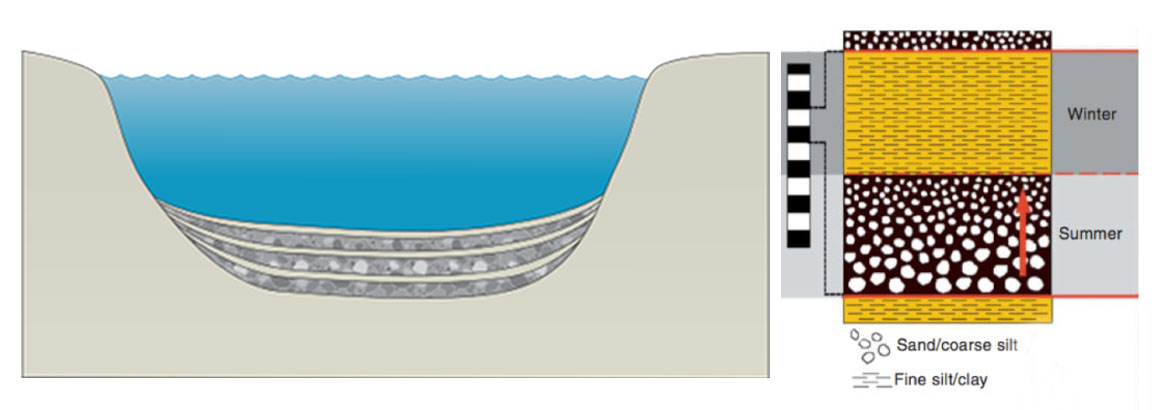
Because each varve represents one year of deposition, like the growth rings of ancient trees, they can be counted to determine how long Lake Merrimack persisted.
Varve thickness varies with distance from the ice margin. Varves deposited near the ice margin are very thick (10 cm – 1 m) because of the large volume of sediment released by the melting ice. As the ice margin recedes from any given spot, varves become thinner due to the reduced supply of sediment to that area away from the ice margin. So, the first varves deposited in an area are the thickest because the ice margin is close. Over time the varves become thinner due to the retreat of the ice margin further north.
In addition to changes in thickness due to distance from the sediment supply, varve thickness also changes from year to year due to variations in glacial melting.
Logging Requirements:
Please do not put your answer in the log. Please email me with the answers to the following questions:
1. From Reference Point 1 you can see the varves close up. Which layer is thicker? Do you see much evidence of annual variation? What does that tell you about the conditions when the varves were created? Take an educated guess: when in the lifetime of the Lake (early, middle or late) do you think these sediments were deposited; and where was the ice margin at the time?
2. At Reference Points 2 and 3 you are standing on top of the Bluffs. Estimate the height of the Bluffs from the Merrimack River. Many of the varves are obliterated by erosion, but do your best to estimate how many years it took to deposit this amount of sediment?
References:
"Glacial Lakes Albany, Champlain, Hitchcock, Winsooski, & Merrimack" by Chris Light Licensed under CC BY-SA 4.0 via Wikimedia Commons - https://commons.wikimedia.org /wiki/File:Glacial_Lakes_Albany,_Champlain,_Hitchcock,_Winsooski,_%26_Merrimack.jpg#/media/File:Glacial_Lakes_Albany,_Champlain,_Hitchcock,_Winsooski,_%26_Merrimack.jpg
University of Maryland Center for Environmental Science (ian.umces.edu/imagelibrary/).
https://paleoecology.wordpress.com/2014/03/31/attaching-dates-to-lake-sediment-cores-precise-dating-using-varves/