History
The Flume was discovered in 1808 by 93-year-old “Aunt” Jess Guernsey when she accidently came upon it while fishing. She had trouble convincing her family of the marvelous discovery, but eventually persuaded others to come and see for themselves. At that time, a huge egg-shaped boulder hung suspended between the walls. The rock was 10 feet (3m) high and 12 feet (3.6m) long. A heavy rainstorm in June of 1883 started a landslide that swept the boulder from its place. It has never been found. The same storm deepened the gorge and formed Avalanche Falls
Geological History
Nearly 200 million years ago in Jurassic times, the Conway granite that forms the walls of the Flume was deeply buried molten rock and dark lava. As it cooled, the granite was broken by closely spaced vertical fractures which lay nearly parallel in a northeasterly direction. Sometime after the fractures were formed, small dikes of basalt were forced up along the fractures. The basalt came from deep within the earth as a fluid material, and because of pressure, was able to force the Conway granite aside. The basalt crystallized quickly against the relatively cold granite. Because of this quick cooling, the basalt is a fine- grained rock. Had this material ever reached the surface, it would have become lava flows.
Erosion gradually lowered the earth’s surface and exposed the dikes. As the overlying rock was worn away, pressure was relieved and horizontal cracks developed, allowing water to get into the rock layers. The basalt dikes eroded faster than the surrounding Conway granite, creating a deepening valley where the gorge is now.
The Flume Gorge
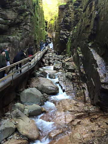
The gorge was covered by glaciers during the Ice Age, but the ice sheet did not greatly change the surface. It partially filled the valley with glacial debris and removed soil and weathered rock from the vicinity. After the Ice Age, Flume Brook began to flow through the valley again.
The highly fractured granite and basalt have been eroded by frost action as well as by the brook’s water. As you walk through the Flume, look at the floor of the Gorge and you many notice remnants of the main basalt dike, and on the walls of the gorge, small trees are growing. Erosion is still occurring.
Geologic Features
There are several significant geological features along the two mile hike that have been formed by glacial movement and erosion.
- Table Rock - Over time, the rushing waters of the Flume Brook exposed this large outcropping of rock. Table Rock is a section of Conway granite
- Avalanche Falls - At the top of the Flume is a close view of Avalanche Falls. The waterfall creates a roaring sound as the Flume Brook enters the gorge. The falls were formed during the great storm of 1883, which washed away the hanging boulder
- Sentinel Pool - The Pool is a deep basin in the Pemigewasset River. It was formed at the end of the Ice Age, 14,000 years ago, by a silt-laden stream flowing from the glacier. The Pool is 40 feet (12m) deep and 150 feet (45m) in diameter, and is surrounded by cliffs 130 feet (39m) high. A cascade rushes into it over fragments of granite that have fallen from the cliffs above
- Glacial Boulders - As you walk through this area, you will notice many boulders. Some are quite large, weighing over 300 tons. During the glacial period over 25,000 years ago, a great ice sheet more than a mile thick moved over this area. The mass of ice was so powerful, it moved both large and small boulders. As the ice sheet retreated, these boulders were left behind. They are called glacial erratics
References: New Hampshire State Park Association (http://www.nhstateparks.org)
Activities
1. Go to the Table Rock area and estimate the width of the rock across the river. Note: Do not go on the water or rocks as they are dangerous
2. When inside the flume look for evidence of the geological formation (e.g. fractures or erosion) and describe it
3. Follow the flume gorge to avalanche falls and estimate the height of the waterfall
4. Send me an e-mail with the answers to your questions and (optional) post a picture anywhere along the gorge