Hastings Country Park is home to the subgroup rock formation known as the Hastings Sands/ Hastings Bed, formed over 120million years ago, the Lower Cretaceous period. This formation consists of dark grey shale, and pale grey sandstone and clay from the Wadhurst Clay formation. The Hastings Beds also consists of sandstone, green/grey siltstones and Fairlight Clay from the Ashdown Formation
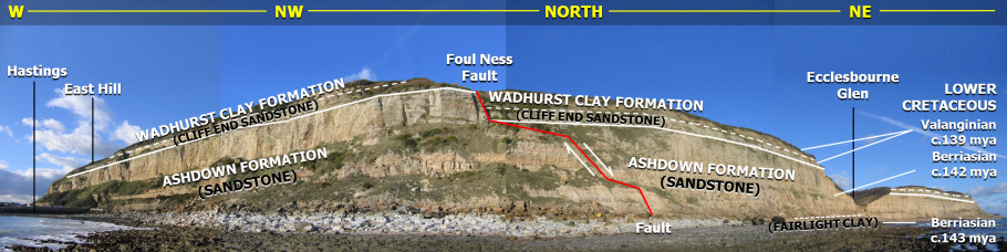

The nearby cliffs are constantly changing with massive rock falls due to the underlying clay being eroded away by the sea. Along with this erosion, the area can become saturated by rainfall leading to landslips, moving access paths. These rock falls and landslips has lead to fossils being discovered along the beach below the cliffs. This sediment dates from the Early Cretaceous epoch roughly 143-139 million years ago, with the sand and silt being deposited by streams and rivers into a large lake.
Hastings is part of the Weald Basin, an area of uplifted land sandwiched between the North and South Downs. The uplift was caused by the build up of pressure between the European and African continental plates, forming the Alps in the process, taking about 30-25 million years ago.
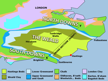
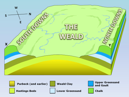
Through erosion these uplifted land has been stripped away revealing the earlier sediments underneath. This has resulted in sedimentary cliffs at Hastings and the local area instead of Chalk cliffs such as the ones at Eastbourne and Dover.
Fairlight Glen (GZ) is surrounded by steep slopes and rock faces formed from the upper Ashford Beds. Two bands of rock formations create a double waterfall in the stream bed, known as the Dripping Well. Over time this stream has caused a narrow inner valley to be formed in the floor of the main valley. The floor of the valley is still however higher than sea level resulting in the stream to cascade down the cliff face onto the beach below.
The coordinates take you to Fairlight Glen where the double waterfall can be seen.
To claim this Earthcache please answer the following questions, by email or the messaging centre:
1) of the surrounding rock faces belong to what rock formation, the Wadhurst Clays or the Ashdown Formation?
2) Roughly how large and what colour is the largest rock at GZ?
3) How tall are the rock faces?
4) Optional - Take a photo of yourself in front of the waterfall, either at GZ or at the foot of the waterfall (be careful, it'll be slippery)
CONGRATULATIONS TO Velosaurus and Mimtysgt FOR FTF To count it as a find message me or email me the answers