

Bem vindo a uma das 7 maravilhas naturais de Portugal
Descobertas em 1947, são as maiores grutas do nosso país e foram declaradas uma das 7 Maravilhas Naturais de Portugal, sendo vencedora na categoria de Grutas e Cavernas.
As Grutas de Mira de Aire, com 11 quilómetros de extensão, dos quais apenas 600 metros são visitáveis, situam-se em plena zona centro de Portugal, uma região muito rica neste tipo de património. Fazem parte integrante do Parque Natural das Serras de Aire e Candeeiros, em pleno maciço calcário e foram formadas há mais de 150 milhões de anos, na Idade Média Jurássica, numa altura em que os dinossauros habitavam a região.
Estas grutas formam-se devido á atuação das águas das chuvas sobre as rochas calcárias predominantes nesta zona.
A água infiltra-se nas fendas das rochas calcárias, fendas essas que vão alargando a erosão natural e pela reação química causada pela presença de dióxido de carbono.
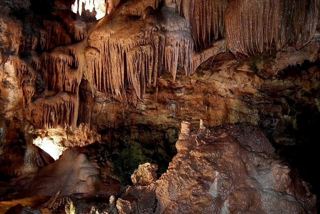
No seu processo de permeabilização estas águas ao atingirem as amplas cavidades anteriormente formadas (grutas) geram pequenas gotas que se desprendem dos tectos, das mais variadas alturas criando nesse processo todo o tipo de formações.
Uma parte destas águas vai naturalmente sofrendo o fenómeno da evaporação, diminuindo assim, substancialmente a quantidade de dióxido de carbono que nela existia inicialmente. Esta operação origina uma reacção química inversa à anterior, ou seja a formação de novo do carbonato de cálcio que, sendo insolúvel, fica suspenso dos tectos sob formas sólidas em formas de vértice para baixo, pela qual vão "crescendo" lentamente através dos séculos sob o nome de estalactites. No entanto, se as gotas, mercê de uma permeabilização mais intensa se desprendem ritmicamente de uma cadência regular, dos tectos, o fenómeno químico concretiza-se, fazendo com que as formações cresçam a partir do chão sendo conhecidas por estalagmites. Quando se dá a união das estalagmites e estalactites dá-se o nome de coluna.
Nos tectos, mercê de fissuras muito estreitas e compridas, por onde as águas terão de escorrer na sua permeabilização, sucede formarem-se frequentemente deslumbrantes formações de finíssimos filamentos cristalinos através do processo já descrito.
Geologia da região:
A região onde se encontra as Grutas de Mira De Aire é composta por serras calcárias. As principais serras são a de Aire e Candeeiros formando assim o Parque Nacional das serras de Aire e Candeeiros.
Devido ás águas das chuvas se infiltrarem nas rochas nesta região não existem rios de água á superfície. Como o calcário é dissolvido pela água são esculpidos nas rochas curiosas formações como pias, marmitas e cristas. Umas das formações geológicas mais estudadas da região são os campos de lápiás. Uma outra característica da região é a denominada “terra rossa”, que é a argila vermelha resultante da dissolução do calcário.

Historial das Grutas de Mira De Aire:
As grutas foram descobertas em 1947 por homens da região que foram atraídos pelo vapor que surgia por entre as rochas.
Desceram por cordas e depararam-se com uma grande sala. Apesar de a visibilidade ser fraca perceberam que algo de grandioso estava a frente deles pois as suas vozes entoavam assim como o barulho das pedras que atiravam.
Dias depois voltaram com mais cordas e partiram á descoberta deste paraíso subterrâneo.
Depois da noticia da descoberta ter chegado a Lisboa, espeleólogos partiram para a região e iniciarem os estudos sobre estas grutas. A crescente descoberta da gruta levaram 2 anos depois á construção de um guincho de madeira para conseguirem passarem um poço com cerca de 20 metros, seguindo-se a construção de diversas escadas para fazer a progressão na gruta.
Ultrapassado esse poço iniciava-se um percurso com cerca de 500 metros, hoje denominado de “Galeria Grande” onde se pode observar várias curiosidades de formações feitas pela água que se assemelham com diversos animais e objetos com por exemplo, elefante, hamster, alforreca e esparguete.
Nos anos 50 e 60 estudos mais prolongados obrigavam a acampamentos no interior da gruta. A descoberta do Poço Final permitiu concluir o primeiro levantamento topográfico da gruta.
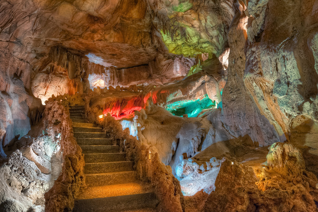
A vontade de partilhar esta maravilha com a população e o aproveitamento turístico fez com que fossem construídos várias centenas de metros de de estrados e escadas.
A abertura ao público dá-se em agosto de 1974.
A descoberta da gruta continuou e em 2007 foi possível acrescentar mais 1km de galerias.
Atualmente a conjugação desta gruta com a gruta da Contenda e gruta da Pena perfazem 11kms de extensão sendo 600 metros abertos ao público.
Para fazer a cache não é necessário visitar as grutas. No entanto deve verificar os seguintes horários disponiveis para visitar a cache:
Outubro/Março: 09:30-17:30
Abril/Maio: 09:30-18:00
Junho/Setembro: 09:30 – 19:00
Julho/Agosto: 09:30-20:00
A visita ás grutas é altamente recomendável.
Para reclamar o "found" terão de ir ás coordenadas para obter informações e responder-me via e-mail ás seguintes questões:
1 – Nas coordenadas indicadas existe uma formação geológica que está vedada. Diga o nome dessa formação geológica e sua descrição.
2 – A formação geológica está na vertical ou horizontal?
3 – Estima as dimensões da formação: (largura x comprimento)
4 – Porque não existem rios á superficie nesta zona?
5 – No Waypoint “Leitor de paisagem”, qual o nome formação geológica descrito pela letra “A”
6- ( Não obrigatório) Uma fotografia que comprova-se a tua presença no local é bem vinda. Não colocar fotos que demonstrem as respostas ás perguntas.
Diverte-te

English
Welcome to one of the 7 natural wonders of Portugal
Discovered in 1947, are the largest caves of our country and have been declared one of the 7 natural wonders of Portugal, and winner in the category of Caves and Caverns .
The Caves of Mira de Aire, with 11 kilometers long, of which only 600 meters are visitable, are situated in the middle of central Portugal, a very rich region in this type of geology. They are part of the Natural Park of Aire and Candeeiros Mountains, in the massive limestone and were formed over 150 million years ago, in the Middle Ages Jurassic, a time when dinosaurs inhabited the region.
Formation of caves:
This caves are formed due to the action of rainwater on limestone rocks predominant in this area.
The water infiltrates the crevices of limestone rocks, these cracks ranging extending the natural erosion and the chemical reaction caused by the presence of carbon dioxide.
In its permeabilization process these waters reach the wide cavities previously formed (caves) generate droplets which are released from the ceilings of various heights creating in this process all types of formations.
A part of this water will naturally suffering the phenomenon of evaporation, thus reducing substantially the amount of carbon dioxide it originally existed. This operation causes a reverse chemical reaction to the previous one, renewing formation of calcium carbonate, being insoluble, is suspended from ceilings in solid forms vertex of ways down, by which they will "grow" slowly through the centuries in the name of stalactites. However, if the drops, thanks to a more intense permeabilization with release of a regular pace pulses, ceilings, chemical phenomenon is implemented by causing the formations grow from the floor being known as stalagmites. When it gives the union of stalactites and stalagmites gives the column name.
Ceilings, thanks to very narrow and long cracks through which water will have to flow in their permeation, are formed after several very curious forms of crystalline filament.
Geology of the region:
The region where the Caves of Mira De Aire consists of limestone mountains. The main mountain ranges are the Aire and Candeeiros forming the National Park of Aire and Candeeiros.
Due to rainwater infiltrating the rocks in this region there are not rivers of water to the surface. As the limestone is dissolved by water are carved in the rocks curious formations as sinks, kettles and ridges. One of the most studied geological formations in the region are the Lapiás fields. Another characteristic of the region is called "Terra Rossa" (red soil), which is the resulting red clay limestone dissolution.
History of Mira de Aire Caves:
The caves were discovered in 1947 by men in the region who were attracted by the steam that came through the rocks
They descended by ropes and are faced with a large room. Although visibiliadde be weak realized that something big was in front of them because their voices intone like the sound of stones throwing.
Days later return with bigger strings and departed the discovery of this underground paradise.
After the news of the discovery have come to Lisbon, speleologists set off for the region and initiate studies on these caves. The increasing discovery of the cave led two years later to the construction of a wooden winch to get pass a well with about 20 meters, followed by the construction of several steps to make progress in the cave.
Exceeded this well begins a journey of about 500 meters, today called the "Grand Gallery" where you can observe several curious formations made by water that resemble various animals and objects such as elephant, hamster, jellyfish and spaghetti.
In the 50s and 60s longer studies forced the camps inside the cave. The discovery of the Final Well allowed to conclude the first topographical map of the cave.
The willingness to share this wonder with the population and the tourist exploitation had them built several hundred meters of platforms and stairs.
The opening to the public takes place in August 1974.
The discovery of the cave continued and in 2007 it was possible to add another 1km galleries.
Currently the combination of this cave to Contenda cave and Pena cave add up to 11kms in length and 600 meters open to the public.
To make the cache is not necessary to visit the caves. However you should check the following times available to visit the cache:
October/March: 09:30-17:30
April/May: 09:30-18:00
June/September: 09:30 – 19:00
July/August: 09:30-20:00
The visit to the caves is highly recommended.
To claim "found" have to go the coordinates for information and reply to me via e-mail find the following issues:
1 –In the given coordinates there is a geological formation that is fenced. Say the name of the geological formation and its description.
2 –The geological formation is vertically or horizontally?
3 –Estimates the size: (width x length)?
4 –Why there are no rivers to the surface in this area?
5 –In Waypoint in "Leitor de paisagem", which the geological formation name described by the letter "A"?
6- (Not required) A photograph that proves to your presence on site is welcome. Do not put pictures that demonstrate the answers to questions.
Have fun