Esker
Esker is a modern term for the gaelic eiscir which means 'ridge of gravel'. They are narrow steep-sided ridges composed of sand and gravel, deposited by glacial meltwater.
Esker Formation
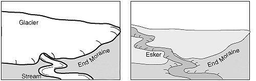
During spring snowmelt and other periods of heavy flow, a river will carve out a channel or valley, and deposit sediment downstream as it meanders through the countryside. Now picture a river of glacial melt-water flowing underneath the surface, carving a tunnel in the base of the ice. It’s river banks are the tunnel walls. This river also deposits sediment downstream in areas of slower flow. However, unlike the rivers we are familiar with, the banks of these glacial rivers eventually melted away, leaving their sedimentary deposits standing as ridges. What had once been a valley is now a ridge. The landscape has become inverted, upside down from what it was when it was forming. Another way of thinking about it is that eskers are gravel casts of sub-glacial tunnels and ice-walled channels.
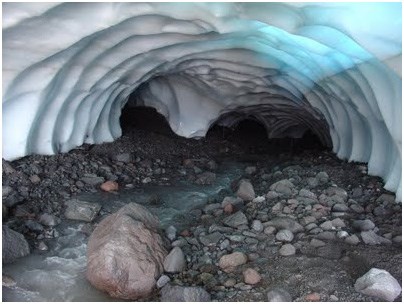
Ice Tunnel
Eskers are recognized by their distinctive serpentine ridges. They may be found as continuous unbroken ridges, but often have gaps that separate the ridges into segments. Eskers are discontinuous because sedimentation may not take place along the entire length of the sub-glacial tunnel. Blocks of the overlying ice may fall into the tunnel, later melting to give kettle-holes along the esker. Alternatively, an esker ridge may become segmented by erosion, either by meltwater during deglaciation or by the action of post-glacial rivers.
Glacial streams can also flow on the surface of a glacier, either carving a channel in the ice, or flowing through an existing crevasse . These surface flows deposit sediment on the ice, and can leave ridges behind when the ice melts.
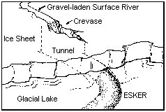
Surface and Subsurface Esker Formation
Logging Requirements:
Please send me an email with your answers to the following questions:
1. The posted coordinates will bring you to a good spot to consider this feature. Do you think the stream that formed this esker was on the surface or at the base of the glacier? Why?
2. Walk the path to each of the virtual stages. Using your GPSr, take an elevation reading at the posted coordinates and at each of the three stages. What is the maximum height of this esker?
3. Based on the elevation at each stage, is this esker continuous or segmented? Please explain.
Sources:
https://www.studyblue.com/notes/note/n/final-exam/deck/11516166 (Northeastern University Environment and Natural Resources)
https://en.wikipedia.org/wiki/Esker
http://www.landforms.eu/cairngorms/esker.htm
Acknowledgements: Many thanks to the Boxborough Conservation Trust for permission to place this Earthcahce, and to the Department of Geology at Tufts University for their technical review.